| Tropical Storm (SSHS) | |
|---|---|
| |
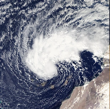
| Tropical Storm Zeta near Canary Islands | |
| Formed | November 8, 2023 |
| Dissipated | November 15, 2023 |
| Highest winds | 10-minute sustained: 40 mph (65 km/h) 3-minute sustained: 40 mph (65 km/h) 1-minute sustained: 45 mph (75 km/h) Gusts: 50 mph (85 km/h) |
| Lowest pressure | 984 mbar (hPa); 29.06 inHg |
| Fatalities | 5 killed |
| Damage | $31 million (2023 USD) |
| Areas affected | Canary Islands,Morroco,Madeira |
| Part of the 2023 Atlantic hurricane season | |
Tropical Storm Zeta was a late-forming tropical storm of the 2023 Atlantic hurricane season which struck the Canary Islands as a strong extratropical storm, causing significant damage and then crossed over Morocco before dissipating. It was the twelve tropical or subtropical storm of the season, Tropical Storm Zeta, like most late-season storms, developed out of an extratropical low. The storm gradually gained tropical characteristics and was briefly a subtropical depression on November 10. Zeta moved erratically for a few days before moving towards the Canary Islands. It became extratropical just before it passed to the north of the archipelago.
.
Meteorological history[]

On November 6, a broad area of eastward-moving low pressure formed in the central Atlantic Ocean about 300 miles southwest of the Azores. It moved steadily eastward through November 7, but on November 8, under the influence of a cold front to its north, the low turned southeastward and started to develop central convection. On November 8, the non-tropical low pressure system began to gain some tropical characteristics, and its northward motion slowed to a stop. Late that afternoon, the low transitioned into a subtropical storm while stalled the storm had already gained enough tropical characteristics to be classified as a tropical storm.
The storm's convection organized around a central core, and the system became a tropical storm on November 12 and received the name Zeta. An eye-like feature appeared near the storm's circulatory center several times that day.The larger-scale deep-layered cyclonic circulation within which it was embedded steered it on a slow southward and then south-southwesterly track. Strong wind shear prevented immediate development and the system added an eastward component to its drift.
As Zeta accelerated to the northeast towards the Canary Islands, it intensified again, reaching a second peak of just under hurricane strength. On November 13, as it neared the Canary Islands Tropical Storm Delta lost its tropical characteristics. The extratropical storm, which maintained winds of near-hurricane strength, passed about 105 mi (165 km) north of the islands that night. The storm moved over Morocco early on November 15 and rapidly weakened overland, dissipating late that day over northwestern Algeria.
Storm Effects[]
Zeta left a trail of damage mainly on the coast of the north side of the Western Islands and strong gusts of wind, with levels that reached a Category 1 hurricane, in coastal areas and the summit. They are the main consequences, none of seriousness, that yesterday left the passage of the third consecutive front that sweeps Canaries, that was in maximum alert and where the classes and practically all the activities in the open air were suspended.
However, according to the delegation in the Islands of the State Meteorological Agency (Aemet), the anticyclone located in North Africa defended more than expected the archipelago of the storm and moved its storm center to the north, continuing its way to Morroco , reason why there was no significant rainfall throughout the day. Yes they had incidence the strong winds associated with the tail, which affected the Archipelago, from midnight yesterday in El Hierro, La Palma and La Gomera.

The operating rooms of the Emergency and Security Coordination Center (Cecoes) 112 recorded more than 300 incidents in all the Islands related to wind, rain and strong waves, most of them related to falling trees and branches, power outages or problems of sewerage.
Hurricane winds The strongest gusts of wind, the most significant of this last storm, occurred yesterday in Vallehermoso (La Gomera), with 152 kilometers per hour, the top of Tenerife - Izaña Meteorological Observatory -, with 147 kilometers per hour, and Agulo (La Gomera), with 122. Likewise, gusts of 121 kilometers per hour were recorded in Tejeda (Gran Canaria) and 113 in Valverde, capital of El Hierro. They also exceeded 100 kilometers per hour at the El Hierro airport (103.4), La Palma airport (101.9) and San Mateo (Gran Canaria, 101.9).
| Olo72 seasons | |
|---|---|
| ATL and EPAC | •EPAC2018
•OSMC2018 •ATL2018 •ATL3092 •ATL1998 •ATL1944 •ATL2020 •EPAC2019 •ATL2024 •ATL2022 •IND2019 •IND2020 •IND2021 •ATL2019 • NA2018 |
| IO and WPAC | IO2018 • WPAC2018 • IO2048 |
| South Hemisfere | SA2344 • SW2046 • SW2018
• AB201819 • SP201819 • SP201920 • SA201819 • AB201920 • SATL1
|
| Other | EA2144 • ONAH • LZ2018 • PCS2019-20 • CS00-50 • LMIS • Med 18-19
|
| Individual Storms | |
|---|---|
| Indstorms&Funstorms | Josue • HHAlberta • CyTrevor• Arabat • Francois • Muserstr • SASC • CAMBRIC • Zena•
• Cyclone Eketsang (Olo72) Taxi • Calif• NUMA • Kevin• KATIA• Zeta• OTTO• BRET• Irmen• CPCMARINA• ALFONSO• LHURRIC• ALBERTOFV3• DARWIN• 3ERASIC • HHC • TSAndrea |