| Tropical storm (SSHWS/NWS) | |
 Tropical Storm Bret approaching landfall in Florida on June 18 | |
| Formed | June 17, 2017 |
|---|---|
| Dissipated | June 22, 2017 |
| (Extratropical after June 20) | |
| Highest winds | 1-minute sustained: 50 mph (85 km/h) |
| Lowest pressure | 997 mbar (hPa); 29.44 inHg |
| Fatalities | 12 direct, 7 indirect |
| Damage | $2.4 million (2017 USD) |
| Areas affected | Cuba, Yucatán Peninsula, East Coast of the United States, Atlantic Canada |
| Part of the 2017 Atlantic hurricane season | |
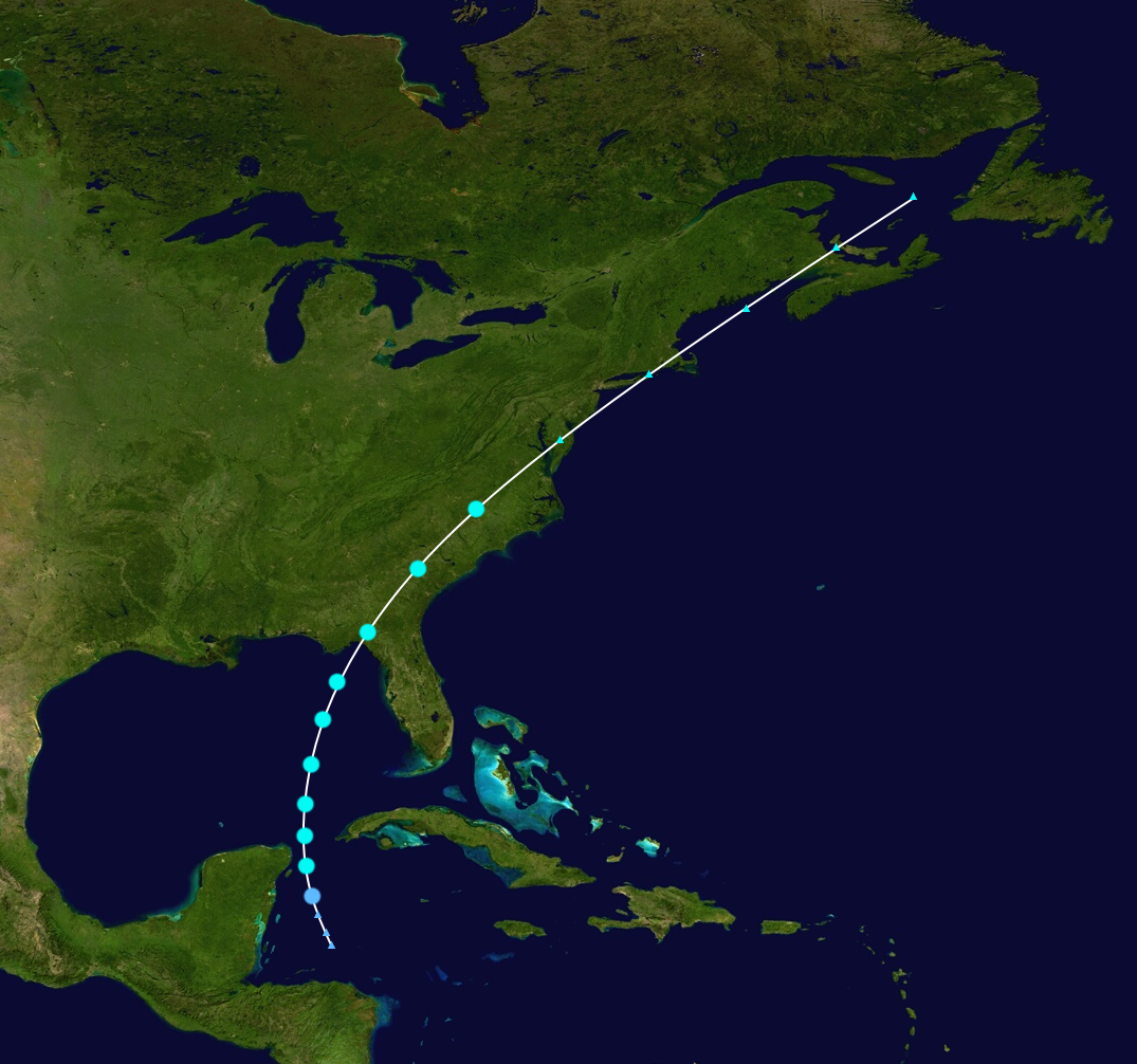
Tropical Storm Bret was a moderate tropical storm which caused some destruction in the western Caribbean in late May of 2017. The second tropical cyclone of the 2017 Atlantic hurricane season, Bret formed from a broad area of low pressure that had developed in the western Caribbean on June 14. Meandering for a few days, it initially failed to organise, but by June 17 it had developed into a tropical depression. It tracked mainly to the northeast, strengthening steadily, and eventually struck Florida at peak intensity on June 19. Shortly afterwards, it accelerated throughout the Northeastern United States before dissipating on June 22 north of Nova Scotia.
Effects, although widespread, were not that damaging due to the intensity of the storm. Twelve people were killed as a result of the storm, mainly from flooding in Cuba and the Yucatán Peninsula. Several injuries occurred in Florida, with damages totalling to US$2.4 million. North Carolina was hit by the torrential rains of Bret, although they were far less damaging then those caused by Hurricane Matthew just eight months prior.
Bret is also known for being the first system to be designated before its actual formation (termed a "potential tropical cyclone) due to the National Hurricane Center's new policy.
Meteorological history[]
Map plotting the storm's track and intensity, according to the Saffir–Simpson scale
Tropical storm (39–54 mph, 63–87 km/h)
Category 1 (74–95 mph, 119–153 km/h)
Category 2 (96–110 mph, 154–177 km/h)
Category 3 (111–129 mph, 178–208 km/h)
Category 4 (130–156 mph, 209–251 km/h)
Category 5 (≥157 mph, ≥252 km/h)
In mid-June, a widespread area of cloudiness and showers associated with a monsoon gyre (which subsequently spawned were present in the western Caribbean Sea. Moderate wind shear initially inhibited any significant development, however, by June 14, a broad area of low pressure formed approximately 120 miles (240 km) east of Honduras. With favorable conditions, including sea surface temperatures around 28°C and decreasing wind shear, gradual organization occurred over the next few days. By June 15, the National Hurricane Center (NHC) initiated advisories on Potential Tropical Cyclone Two at 15:00 UTC that day, the first such system under its new policy for naming disturbances since the system had a high chance of tropical cyclogenesis, and that it was expected to bring tropical-storm force winds to the Yucatán Peninsula within the following 48 hours. They also added that "only a small amount in organization would result in classification of a tropical cyclone". By the next day, Hurricane Hunters observed a well-defined circulation within sufficient atmospheric convection, and the system was marked as forming as a tropical depression at 21:00 UTC on June 17.
Immediately after designation as a tropical cyclone, the system quickly organized, with convection wrapping around the center, resulting in the depression strengthening into a tropical storm, which was assigned the name Bret accordingly, the second name of the 2017 Atlantic hurricane season. It made its closest approach to the Yucatán Peninsula approximately 12 hours after formation, bringing gusty winds and heavy rainfall to the region. As Bret moved swiftly into the Gulf of Mexico, further intensification occurred until it reached its peak intensity at 18:00 UTC on June 18 while west of Florida. Shortly afterwards, wind shear began to increase slightly, resulting the Bret becoming disorganized and weakening somewhat.