| Category 5 major hurricane (SSHWS/NWS) | |
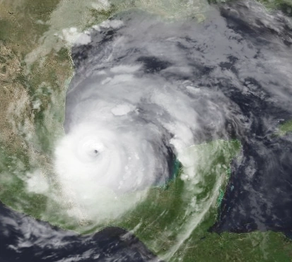 Hurricane Taylor at peak intensity | |
| Formed | September 5 |
|---|---|
| Dissipated | September 9 |
| Highest winds | 1-minute sustained: 165 mph (270 km/h) |
| Lowest pressure | 935 mbar (hPa); 27.61 inHg |
| Fatalities | 87 |
| Damage | $2.6 billion (2017 USD) |
| Areas affected | Mexico |
| Part of the 2017 What-might-have-been Atlantic Hurricane Season (Farm River) | |
Hurricane Taylor is a rare Category 5 gurricane in the Bay of Campeche. It formed in the Gulf of Mexico, then it emerged in the Bay of Campeche. Rapid intensification allowed Taylor to reach Category 5 status. It hit Mexico at peak intensity, causing damage more than $2.5 billion. It was weakened by mountain terrain, and degenerated. It's remnants contributed to a formation of a major hurricane in the Pacific.
Meteorological History[]
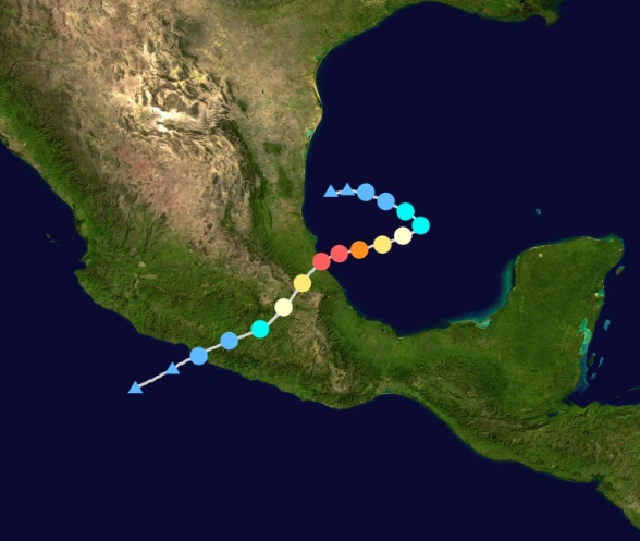
Track plotting the track and intensity of the storm according to the Saffir-Simpson scale
A trough was present over the southwestern Gulf of Mexico on September 1, producing a widespread area of convection. Four days later, a distinct low pressure area formed. At 21:00 UTC that day, the NHC designated the system as Tropical Depression Nineteen after an organized area of convection formed. Located in an area of weak steering currents, the depression drifted gradually eastward. Decreasing wind shear and warm water temperatures made the system intensified into Tropical Storm Taylor on September 6, as the convection rapidly organized. Later that day, an aircraft reconnaissance flight into the storm found surface winds of 75 mph (120 km/h); which made NHC upgrade Katia to hurricane status. The convection organized into a central dense overcast as the system stalled. It formed an organized eyewall as it began to rapidly intnsify. Reconnaissance aircraft found out that Taylor had strengthened to 165 mph, prompting NHC to upgrade it to Category 5. Late in the evening of September 8, Katia made landfall in Mexico at it's peak. The system rapidly dissipated over land the next day.
Impact[]
Mexican president Enrique Peña Nieto declared State of Emergency on areas of Veracruz and Puebla. As Taylor transverse over the areas, several businesses closed, and storm surge was reported along the coastline of Veracruz. Damage was heavy, amounting to almost $2.6 billion and 87 fatalities. Taylor also marked the third consecutive Category 5 hurricane, next to Seth, which is a rare event. Taylor also caused massive evacuations in the area, resulting of 3 indirect deaths.
Retirement[]
Due to the impact of the storm, the World Meteorological Organization decided to retire the name Taylor and will never be used again for another Atlantic hurricane. The name Tiffany was chosen to replace the name in 2023.