Write the first paragraph of your page
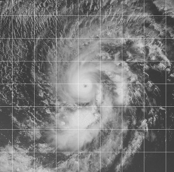
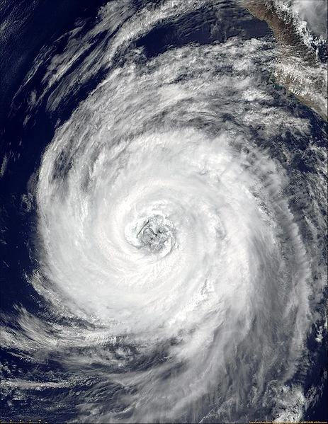
Hurricane Amanda[]
| Category 4 tropical cyclone (NHC) | |
  | |
| Duration | June 26 – July 1 |
|---|---|
| Peak intensity | 250 km/h (155 mph) (1-min) 932 hPa (mbar) |
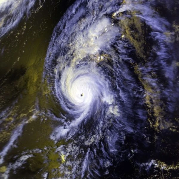
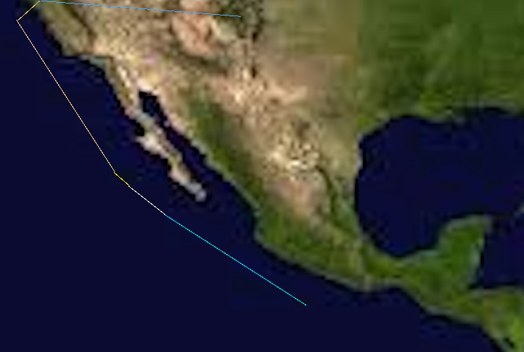
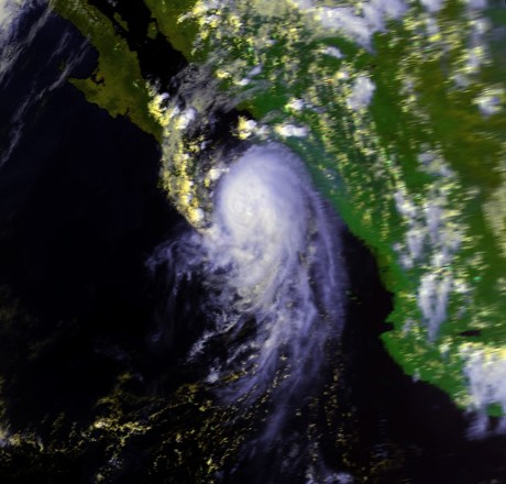
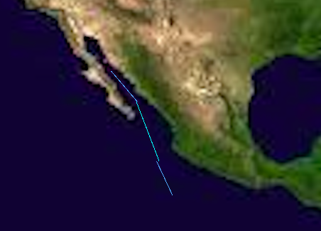
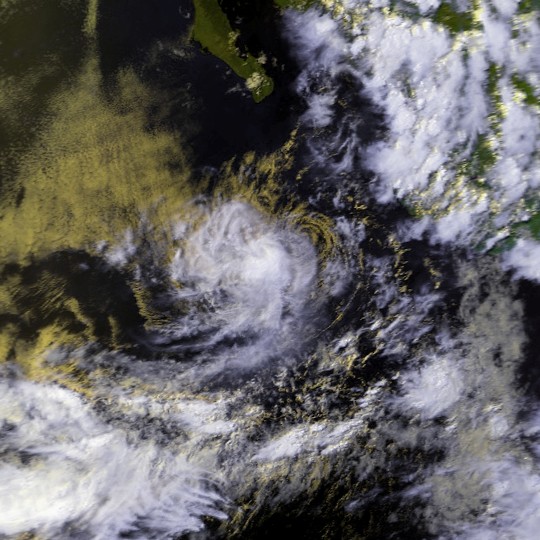
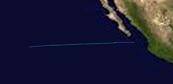
On June 26, A tropical wave spawned a weak low pressure system, which got upgrade to Tropical storm Amanda. Early on in it's life, Tropical storm Amanda remained disorganized due to heavy shear from a front. However, on june 28, it eventually reached an area of almost 90˚ waters and very low shear, and rapidly strengthened into a category 4 monster in a little under 12 hours. It weakened slightly to a 125 mph category 3 before making landfall in baja california on June 30. It weakened rapidly, and made its final landfall as tropical depression in Sonara, Mexico, before dissipating on July 1. Amanda ended up costing 308 million dollars and killed 8. In the spring of 2015, it was retired and replaced with Ariel for the 2020 season.
Tropical Storm Boris[]
| Tropical storm (SSHWS) | |
  | |
| Duration | July 2 – July 5 |
|---|---|
| Peak intensity | 100 km/h (65 mph) (1-min) 998 hPa (mbar) |
On July 2, 1 day after Amanda disspated, A wave spawned TD 2-E. 6 hours later it was upgraded to Tropical Storm Boris. On July 4, Boris Reached a peak of 65 MPH, with 998 mbs pressure, before running into cooler waters and shear, and on July 5, Boris dissipated.
Hurricane Pewa[]
| Category 2 tropical cyclone (SSHWS) | |
  | |
| Duration | July 8 – July 16 |
|---|---|
| Peak intensity | 165 km/h (105 mph) (1-min) 972 hPa (mbar) |
On july 7, an organized area of thunderstorms deattached itself from the ICTZ 800 miles south of Hawaii. On july 8, it began to show signs of development and was upgraded to TD 1-C. After one advisory, It was upgraded to tropical storm Pewa. Movement was slow and to the north. After 3 days of steady strengthening, Pewa reached a peak of 105 mph winds about 100 miles south of Hawaii on July 10. It then made landfall on Maui as a low end cat 2 in the late evening hours of July 11. It then exited Maui and weakened over colder waters north of the island, before finally disspating about 1200 miles north of Maui on July 16. Damage was extensive, amounting to $600 million with 10 fatalities. In the spring 2015, It was retired and replaced with Pua.
Hurricane Cristina[]
| Category 5 tropical cyclone (SSHWS) | |
  | |
| Duration | July 13 – July 26 |
|---|---|
| Peak intensity | 280 km/h (175 mph) (1-min) 900 hPa (mbar) |
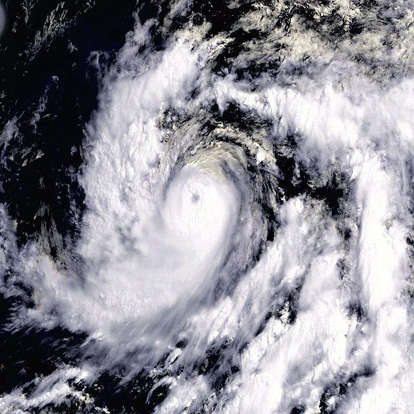
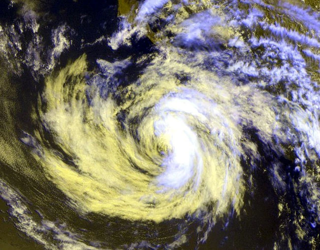
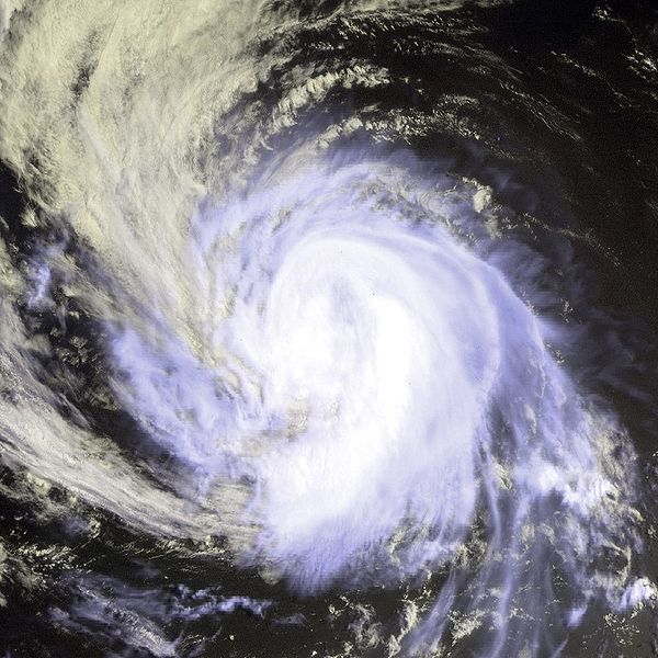
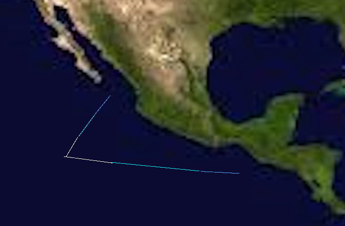
On July 12, A tropical wave about 800 miles southeast of Acapulco began to show signs of development, and was subsequently upgraded to TD 3-E at 0200 UTC on July 13. Warm Waters and Low shear helped the developing cyclone, and consequently at 0600 UTC it was upgraded to Tropical storm Cristina. Cristina Kept on strengthening, and by July 16 It developed into a hurricane. It then rapidly strengthened into a major hurricane on july 17, Before 1 advisory later peaking out as a monster Category 5 with 175 MPH winds and 900 Mbs of pressure. It held cat 5 for sometime before cold water and increasing shear got the best of it, now located about 1000 miles north of Hawaii. It then rapidly weakened and became extratropical on July 26. It never impacted land.
Hurricane Douglas[]
| Category 4 tropical cyclone (SSHWS) | |
  | |
| Duration | July 24 – August 3 |
|---|---|
| Peak intensity | 230 km/h (145 mph) (1-min) 932 hPa (mbar) |
On July 24, A tropical wave spawned the 5th depression of the season about 900 miles south of Acapulco. It strengthened the next day into Tropical storm Douglas. After 3 days of slow strengthening, It was upgraded to a hurricane 800 miles south of Baja California. Douglas then entered the same environment Cristina did, and rapidly strengthened to a major hurricane on July 28. 1 day later it peaked out as a category 4 hurricane located 900 miles east of Hawaii. Douglas then began to weaken as a ridge strengthened and forced it south of the islands. It ran into a wall of shear on August 2, and 1 day later it disspated southwest of the main island. Douglas had no impact on land.
TD 5-E[]
| Tropical depression (SSHWS) | |
  | |
| Duration | August 2 – August 5 |
|---|---|
| Peak intensity | 55 km/h (35 mph) (1-min) 1005 hPa (mbar) |
On August 2nd, an area of thunderstorms Spawned TD-5-E south of Baja california. It was intially expected to strengthen, but it failed to do so. It disspated 3 days later due to colder waters. No land was affected.
Hurricane Elida[]
| Category 3 tropical cyclone (SSHWS) | |
  | |
| Duration | August 8 – August 19 |
|---|---|
| Peak intensity | 205 km/h (125 mph) (1-min) 965 hPa (mbar) |
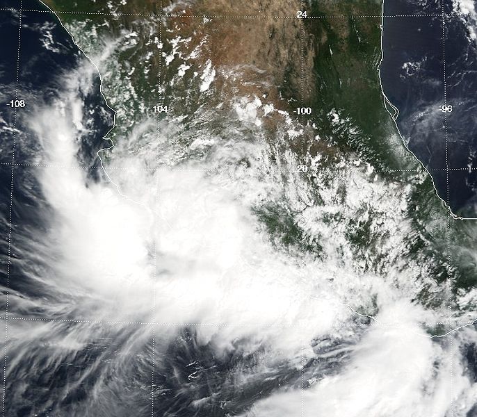
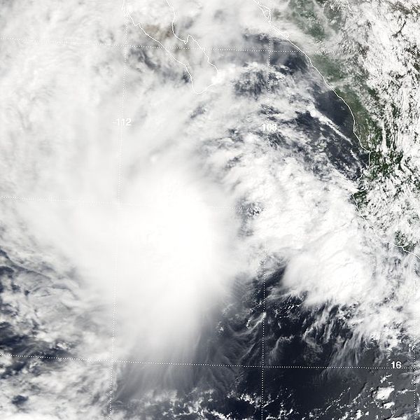
On August 8, A tropical wave located about 650 miles southwest of manzanillo began to show development, and was upgraded directly to Tropical storm Elida. Forecasts indicated Elida would follow a path similar to Cristina and Douglas, but a sudden trough over california forced the storm north. After 2 days of strengthening Elida hit the same sweet spot that Cristina and Douglas hit and rapidly strengthened into A category 3 hurricane on August 11. Elida maintained this strength up until landfall on the california coastline in San Fransisco. Extreme Damage was caused, Upwards of 100 billion dollars of damage and killed 500. In the spring of 2015, Elida was retired and replaced with Elizabeth.
Tropical storm Fausto[]
| Tropical storm (SSHWS) | |
  | |
| Duration | August 13 – August 15 |
|---|---|
| Peak intensity | 65 km/h (40 mph) (1-min) 998 hPa (mbar) |
On august 13, a storm spawned a tropical depression. The next day it strengthened into tropical storm Fausto. The following day fausto degenerated into an area of low pressure. Fausto did not affect land.
Hurricane Genevive[]
| Category 5 tropical cyclone (SSHWS) | |
 | |
| Duration | August 20 – September 3 |
|---|---|
| Peak intensity | 260 km/h (160 mph) (1-min) 912 hPa (mbar) |
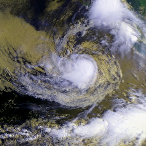
On August 20, A tropical wave developed into Tropical storm Genevive, skipping Tropical depression strength. This storm, like Cristina and Douglas, began to move West north westward, and ran into an area of low shear with warm waters on August 24. Genevive rapidly strengthened into the seasons 7th hurricane. It kept on strengthening, surpassing major hurricane strength on August 27, and One day later on the 28th peaked out as a category 5 cyclone. It then ran into an area of shear and colder waters east of hawaii, and rapidly weakened before dissipating on September 3. Genevive caused large swells in california, but besides that no damage occured and no deaths occured.
Hurricane Hernan[]
| Category 2 tropical cyclone (SSHWS) | |
 | |
| Duration | August 26 – September 9 |
|---|---|
| Peak intensity | 155 km/h (100 mph) (1-min) 976 hPa (mbar) |
On August 26, an area of thunderstorms emerged into the gulf of Tehuanapetec. It developed into a depression on the same day. It moved west, and was upgraded to Tropical storm Hernan. Hernan kept on graudally strengthening, and on august 30 was upgraded to a hurricane. It continued strengthening and peaked as a category 2 900 miles south of baja california on September 4. It then ran into shear on September 6 and began weakening. It degenerated into an area of low pressure September 9. Hernan did not affect land.
Hurricane Iselle[]
| Category 1 tropical cyclone (SSHWS) | |
  | |
| Duration | September 5 – September 11 |
|---|---|
| Peak intensity | 140 km/h (85 mph) (1-min) 981 hPa (mbar) |
On September 3, a wave began to show signs of development just of the coast of central america. It was upgraded to a tropical depression the same day. On the following day, It strengthened into tropical storm Iselle. Iselle kept on strengthening, and on September 6 it was upgraded to a hurricane. It was intially expected to become a major hurricane, but failed. On September 9, it was downgraded to a tropical storm, and on September 11, it disspated south of Mexico. It never affected land.
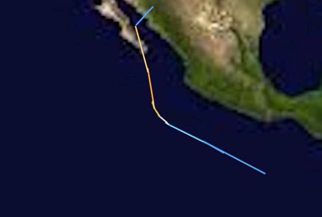
Tropical storm Julio[]
| Tropical storm (SSHWS) | |
  | |
| Duration | September 10 – September 13 |
|---|---|
| Peak intensity | 75 km/h (45 mph) (1-min) 1002 hPa (mbar) |
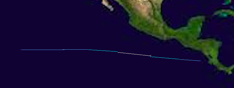
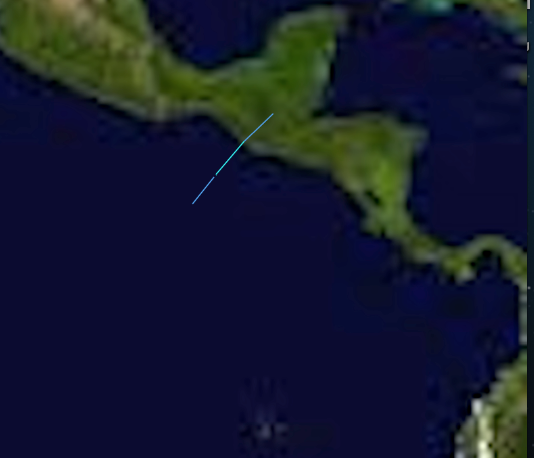
On September 10, a wave spawned a Tropical depression of the coast of Guatemala. It moved Northeast, and the next day, it was upgraded to Tropical storm Julio before making landfall in Guatemala the same day. It disspated quickly over land. About $20 million was caused, and 5 deaths were recorded. It was not retired.
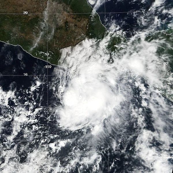
Tropical storm Karina[]
| Tropical storm (SSHWS) | |
  | |
| Duration | September 15 – September 20 |
|---|---|
| Peak intensity | 110 km/h (70 mph) (1-min) 992 hPa (mbar) |
On september 15, An organized area of thunderstorms spun off of the ICTZ, and immediately developed into tropical storm Karina south of acapulco. Karina began moving North. Forecasters were concerned because Karina was entering the same area Hurricane Elida had earlier. Karin however, failed to strengthen into a hurricane. It went into the gulf of california on September 18, and disspated on september 20. Despite proximity to land, Karina never made a landfall, but caused high surf and light rain in Baja California.
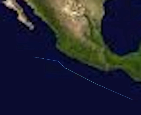
Hurricane Lowell[]
| Category 1 tropical cyclone (SSHWS) | |
  | |
| Duration | September 24 – October 2 |
|---|---|
| Peak intensity | 150 km/h (90 mph) (1-min) 986 hPa (mbar) |
On September 22, a wave emerged into the basin and was monitored for development. 2 days later, The wave spawned Tropical storm Lowell, skipping Tropical Depression. Lowell moved west north west, and eventually strengthened into a category 1 on September 26. It reached its peak on September 28. Lowell then began to weaken, and abruptly turned north. Lowell continued weakening, and degenerated on October 2. Lowell brought high surf and rain to Mexico, but did not make landfall.
Tropical storm Marie[]
| Tropical storm (SSHWS) | |
  | |
| Duration | September 29 – October 5 |
|---|---|
| Peak intensity | 65 km/h (40 mph) (1-min) 999 hPa (mbar) |
On September 29, a tropical wave spawned a Tropical depression south of Baja California. It moved West, and 1 day later developed into Tropical storm Marie. Marie was forecast to become a hurricane, but failed to do so. It maintained tropical storm strength thru October 2nd. It then weakened, and Disspated on October 5.