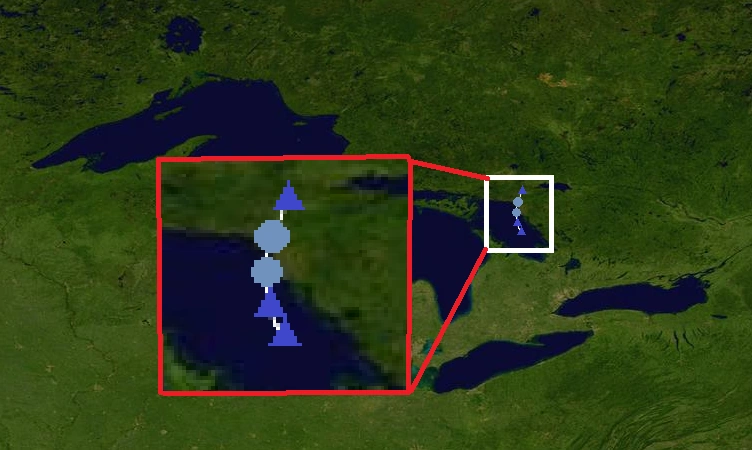
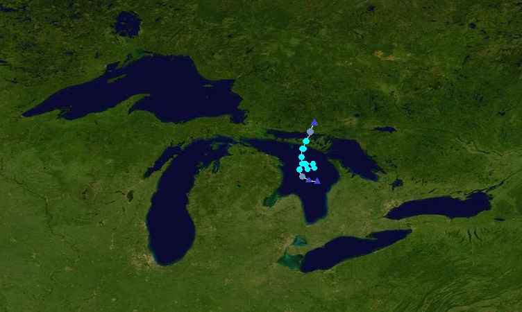
The 2013 Great Lakes hurricane season was the first year on record in which tropical cyclones formed in the Great Lakes. It was very active, with 16 depressions, 12 storms, 7 hurricanes, and 2 majors forming. It officially started on June 1 and ended on November 30 (same bounds as the Atlantic). These dates conventionally delimit the period of each year when most tropical cyclones form in the Great Lakes. However, the first storm, STD One, formed on April 29, more than a month before the official start of the season.
This season was very destructive, with Bob, Fred, and Ingrid responsible for most of the destruction. The strongest and most destructive of the season was Fred, a Category 5 that formed in Lake Michigan, crossed into Lake Superior, looped back into Lake Huron, and then crossed into Lake Erie and Lake Ontario. It caused $40 billion in damage and killed 232 people throughout the Great Lakes region. The name Fred, along with Bob and Ingrid, were later retired and replaced by Bud, Fabian, and Irene for the 2019 season. The Great Lakes rotates names every six years just like in the Atlantic and the Pacific.
Season summary[]
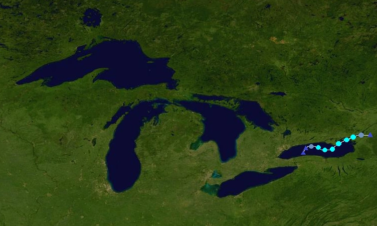
The season started with STD One, a subtropical depression that existed in Lake Huron during late April. It formed more than a month before the official start of the season. Later, in June, 2 storms formed. They were TD Two and Hurricane Allison. After that, July saw 4 storms, Bob, Cindy, Daniel, and TD 7. Bob was the most destructive of the month, hitting Syracuse and Toronto at C1 intensity. In August, 3 storms formed. They were Emily, Fred, and Greta. Fred was the strongest and most destructive of the month as well as the season, reaching C5 intensity and affecting a lot of land in the Great Lakes region. In September, 3 storms, Henri, Ingrid, and TD Thirteen formed. The most destructive of the month was Ingrid, which hit downtown Chicago at C2 intensity. In October, 2 storms, Jack and Kristy formed. Finally, in November, 1 storm, Lorenzo formed. Overall, this season was an active one.
Timeline[]

List of storms[]
Subtropical Depression One[]
| Subtropical depression (SSHWS) | |
  | |
| Duration | April 29 – April 31 |
|---|---|
| Peak intensity | 30 mph (45 km/h) (1-min) 1008 mbar (hPa) |
An area of disturbed weather formed in Lake Huron on April 28. It quickly developed and became Subtropical Depression One the next day. STD One moved northeastward, moved into Georgian Bay, and later made a landfall near Espanola on April 30. It dissipated later that day. STD One didn't cause any damage.
Tropical Depression Two[]
| Tropical depression (SSHWS) | |
  | |
| Duration | June 8 – June 9 |
|---|---|
| Peak intensity | 35 mph (55 km/h) (1-min) 1003 mbar (hPa) |
An area of thunderstorms formed in Lake Michigan on June 7. It quickly developed and became a depression the next day. TD Two moved northwestward and later made a landfall north of Milwaukee without ever strengthening into a tropical storm. It dissipated over land. TD Two caused very minimal damage.
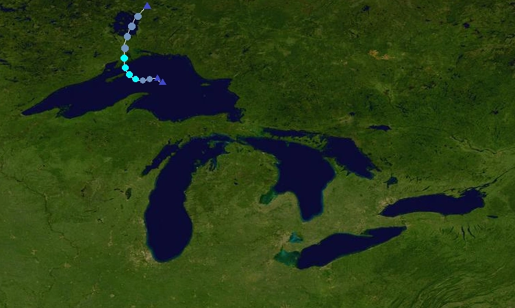
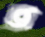
Hurricane Allison[]
| Category 1 hurricane (SSHWS) | |
  | |
| Duration | June 20 – June 26 |
|---|---|
| Peak intensity | 80 mph (130 km/h) (1-min) 987 mbar (hPa) |
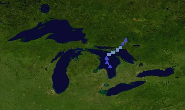
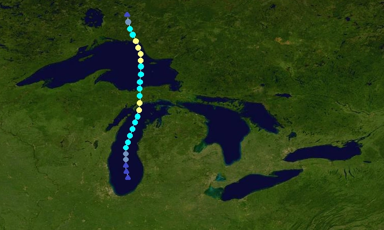
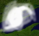
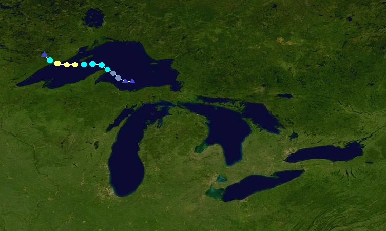
The GLHC (Great Lakes Hurricane Center) began to monitor an area of disturbed weather in southern Lake Michigan on June 19. It became a depression the next day. The depression strengthened into a tropical storm 12 hours later. Allison gradually strengthened as it moved northward through Lake Michigan, later becoming a hurricane on June 22. It then made landfall near Escanaba that night, and then weakened into a tropical storm as it emerged into Lake Superior. After emerging into Lake Superior, it started to strengthen again. Allison restrengthened into a hurricane on June 24 and later reached its peak of 80 mph and 987 mbar. It made a landfall near Marathon, before quickly weakening over land and dissipating on June 26. Allison caused $78 million in damage and killed 6 people.
Hurricane Bob[]
| Category 1 hurricane (SSHWS) | |
  | |
| Duration | July 6 – July 10 |
|---|---|
| Peak intensity | 80 mph (130 km/h) (1-min) 988 mbar (hPa) |
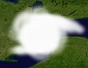
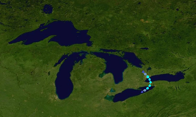
A depression formed on July 6 in Lake Erie from an area of disturbed weather. The depression strengthened into TS Bob 6 hours later. Bob moved eastward through Lake Erie as it gradually strengthened. It became a hurricane early on July 8 and soon reached its peak of 80 mph and 988 mbar. The storm then made landfall near Port Colborne later that day. Bob weakened into a tropical storm over land and affected the cities of Buffalo and Niagara Falls before emerging into Lake Ontario with 60 mph winds. In Lake Ontario, it quickly restrengthened into a hurricane and then made landfall near Oshawa on July 9. The storm quickly weakened over land before dissipating on July 10. Bob caused $865 million in damage and killed 27 people. The name was later retired and replaced by Bud for the 2019 season.
Tropical Storm Cindy[]
| Tropical storm (SSHWS) | |
  | |
| Duration | July 14 – July 17 |
|---|---|
| Peak intensity | 60 mph (95 km/h) (1-min) 996 mbar (hPa) |
An area of disturbed weather formed in Lake Superior on July 13. It quickly developed and became a depression the next day. It strengthened into a tropical storm 12 hours after becoming a depression. Cindy continued to strengthen, and reached its peak of 60 mph and 996 mbar before making landfall east of Thunder Bay late on July 15th. It weakened into a depression over land, before emerging into Lake Nipigon. The lake caused it to maintain depression status before dissipating on July 17. Cindy caused $12 million in damage and killed no-one.
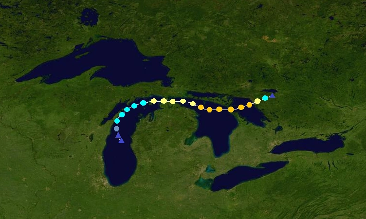
Hurricane Daniel[]
| Category 3 hurricane (SSHWS) | |
  | |
| Duration | July 19 – July 28 |
|---|---|
| Peak intensity | 125 mph (205 km/h) (1-min) 955 mbar (hPa) |
A tropical depression formed in Lake Huron on July 19. It quickly strengthened into TS Daniel 6 hours later. Continuing to strengthen, Daniel became a hurricane before making landfall near Sault Ste. Marie on July 21 with winds of 80 mph. It weakened into a tropical storm over land and emerged into Lake Superior as a 60 mph TS. Daniel quickly restrengthened into a hurricane as it moved westward through Lake Superior, and continued to strengthen under favorable conditions. It soon became a Cat. 2 and then a major C3 hurricane. Daniel reached its peak of 125 mph and 955 mbar before weakening. It made landfall near Duluth on July 27 and dissipated on July 28 over land. Daniel caused $436 million in damage and killed 18 people.
Tropical Depression Seven[]
| Tropical depression (SSHWS) | |
  | |
| Duration | July 29 – July 30 |
|---|---|
| Peak intensity | 35 mph (55 km/h) (1-min) 1004 mbar (hPa) |
An area of disturbed weather formed in Georgian Bay on July 28. It quickly developed and became a depression the next day. The depression soon made landfall near Mowat without strengthening into a TS, and dissipated on July 30. TD 7 didn't cause any damage or deaths.
Tropical Storm Emily[]
| Tropical storm (SSHWS) | |
  | |
| Duration | August 5 – August 7 |
|---|---|
| Peak intensity | 60 mph (95 km/h) (1-min) 995 mbar (hPa) |
The GLHC began to monitor an area of disturbed weather in Lake Ontario on August 4. It became a depression the next day and later became TS Emily. Emily moved eastward and gradually strengthened to its peak of 60 mph and 995 mbar. It then made landfall near Kingston, before weakening and dissipating on August 7 over land. Emily caused $60 million in damage and killed 4 people.
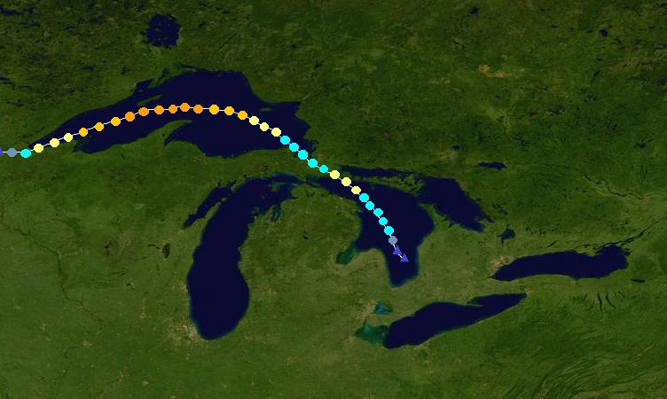
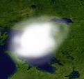
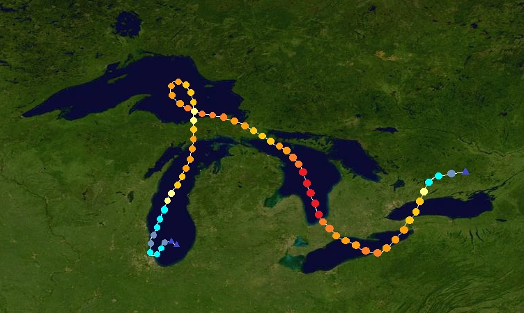
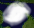
Hurricane Fred[]
| Category 5 hurricane (SSHWS) | |
  | |
| Duration | August 13 – August 29 |
|---|---|
| Peak intensity | 165 mph (270 km/h) (1-min) 912 mbar (hPa) |
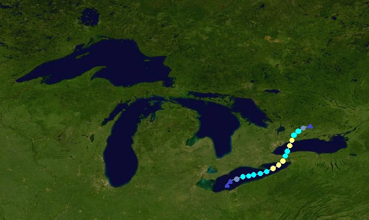
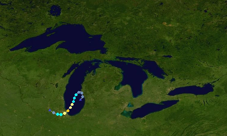
A depression formed in southern Lake Michigan on August 13. It later strengthened into TS Fred and made landfall in Chicago on August 14 with 50 mph winds. After making landfall, it turned north and emerged back into Lake Michigan as a tropical depression. Fred gradually strengthened as it moved northward through the Gulf of Mexico, later becoming a Cat. 3 hurricane before making landfall near Escanaba on August 17. Fred then emerged into Lake Superior as a C1, and started to strengthen again. It looped back towards the southeast and strengthened into a Cat. 4 before making landfall near Sault Ste. Marie on August 21. Fred emerged into Lake Huron as a C2, and right after entering that lake, started to rapidly strengthen as it moved southward. The storm soon became a Category 5 and then peaked with 165 mph winds and a 912 mbar pressure. It then made landfall on the southernmost shore of Lake Huron, before emerging into Lake Erie as a C3. In Lake Erie, it restrengthened into a C4 and made landfall near Erie, Pennsylvania on August 26. The storm weakened into a C3 and turned back towards the northeast, later making landfall near Port Colborne as a 120 mph C3 early on August 27. Fred weakened into a C2 as it emerged into Lake Ontario, and then made a final landfall near Oshawa that night. Fred weakened over land before dissipating early on August 29. Fred caused $40 billion in damage and killed 232 people throughout its extremely destructive and unusual track. The name Fred was later retired and replaced by Fabian for 2019.
Hurricane Greta[]
| Category 2 hurricane (SSHWS) | |
  | |
| Duration | August 26 – August 31 |
|---|---|
| Peak intensity | 110 mph (175 km/h) (1-min) 968 mbar (hPa) |
The GLHC began to monitor an area of disturbed weather in Lake Michigan on August 25. It quickly developed and became a depression the next day, later becoming TS Greta. Greta soon passed very close to the coast of Wisconsin, turned eastward, and strengthened into a hurricane under favorable conditions. It then went along the northern Michigan coast and entered Lake Huron. In Lake Huron, Greta strengthened into a Cat. 2 hurricane and reached its peak of 110 mph and 968 mbar as it entered Georgian Bay. It made landfall in Canada, and dissipated on August 31 over land. Greta caused $85 million in damage and killed 2 people.
Tropical Storm Henri[]
| Tropical storm (SSHWS) | |
  | |
| Duration | September 3 – September 7 |
|---|---|
| Peak intensity | 65 mph (100 km/h) (1-min) 993 mbar (hPa) |
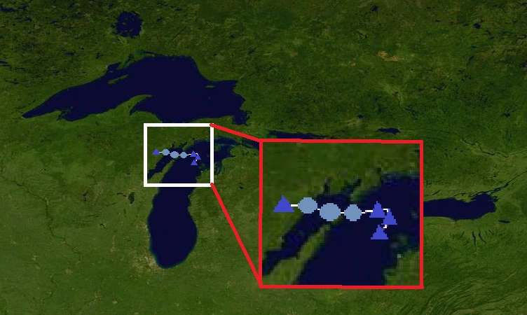
A tropical depression formed in western Lake Erie on September 3. It became TS Henri, and reached a first peak of 45 mph and 998 mbar before making landfall on the northern shore of Lake Erie on September 4. Henri dissipated over land, but its remnants tracked into Lake Huron, where it redeveloped late on September 5. It restrengthened into a tropical storm, and reached its peak of 65 mph and 993 mbar. Henri made landfall in northern Michigan early on September 7. It dissipated later that day over land. Henri caused $36 million in damage but killed no-one.
Hurricane Ingrid[]
| Category 2 hurricane (SSHWS) | |
  | |
| Duration | September 12 – September 15 |
|---|---|
| Peak intensity | 105 mph (165 km/h) (1-min) 972 mbar (hPa) |
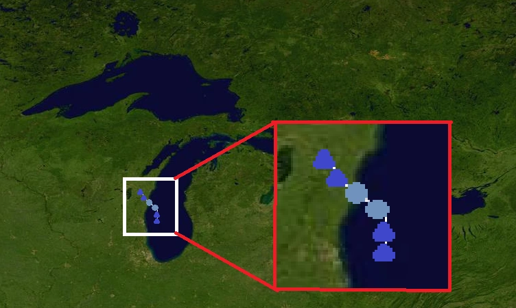
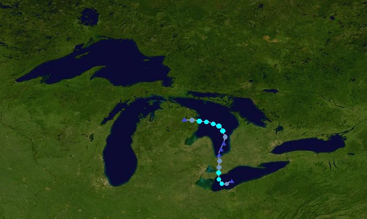
A disturbance formed in southern Lake Michigan on September 10. It became a depression very close to the west coast of Michigan on September 12, and made landfall before turning back out into the lake and strengthening into TS Ingrid. It turned southward and quickly strengthened under favorable conditions. Ingrid became a hurricane and later a Cat. 2 hurricane, reaching a peak of 105 mph and 972 mbar before making landfall in Chicago on September 14. It quickly weakened over land before dissipating on September 15. Ingrid caused $2.6 billion in damage and killed 39 people. The name was later retired and replaced by Irene for 2019.
Tropical Depression Thirteen[]
| Tropical depression (SSHWS) | |
  | |
| Duration | September 26 – September 27 |
|---|---|
| Peak intensity | 35 mph (55 km/h) (1-min) 1002 mbar (hPa) |
An area of disturbed weather formed in northern Lake Michigan on September 25. It became a depression the next day. The depression tracked westward before making landfall near the Wisconsin-Michigan border early on September 26 without ever becoming a tropical storm. It dissipated later that day. The depression didn't cause any damage.
Hurricane Jack[]
| Category 1 hurricane (SSHWS) | |
  | |
| Duration | October 8 – October 11 |
|---|---|
| Peak intensity | 85 mph (140 km/h) (1-min) 982 mbar (hPa) |
A depression formed in southern Lake Superior on October 8. It later became TS Jack, and continued to strengthen as it moved westward. Jack became a hurricane early on October 10 due to favorable conditions. The storm reached its peak of 85 mph and 982 mbar before making landfall in Canada later that day. It dissipated early the next day. Jack caused $24 million in damage and killed no-one.
Tropical Storm Kristy[]
| Tropical storm (SSHWS) | |
  | |
| Duration | October 29 – October 31 |
|---|---|
| Peak intensity | 50 mph (85 km/h) (1-min) 997 mbar (hPa) |
An area of disturbed weather became a depression on October 29 in eastern Lake Erie. The depression strengthened into Tropical Storm Kristy 6 hours later. It then strengthened to 45 mph before making landfall near Port Colborne. Kristy remained a tropical storm as it emerged into Lake Ontario. It turned northwestward and strengthened to its peak of 50 mph and 997 mbar before making landfall near Toronto late on October 30. It dissipated the next day. Kristy caused $210 million in damage and killed 13 people. In Toronto, Kristy was known as The Halloween Storm of 2013 because it struck on Halloween.
Tropical Storm Lorenzo[]
| Tropical storm (SSHWS) | |
  | |
| Duration | November 14 – November 17 |
|---|---|
| Peak intensity | 65 mph (100 km/h) (1-min) 994 mbar (hPa) |
The GLHC began to monitor a disturbance in Lake Huron on November 13. The disturbed weather became a depression the next day, and strengthened into TS Lorenzo 6 hours after becoming a depression. Lorenzo did a cyclonic loop and reached its peak of 65 mph and 994 mbar before making landfall on the northern shore of Lake Huron (in Canada) early on November 16. It continued northward and dissipated early on November 17. Lorenzo caused minimal damage.
Storm names[]
The following names were used to name tropical cyclones this year. This was the first time that names were used to name tropical cyclones that formed in the Great Lakes, since this is the first time on record that hurricanes formed there. The names will rotate every 6 years, with the same names used in 2013 to be used in 2019 except for retirements. Unused names are marked in gray.
|
|
|
Retirement[]
Due to extensive damage and deaths, the names Bob, Fred, and Ingrid were officially retired, and will never be used again for a Great Lakes hurricane. They were replaced by Bud, Fabian, and Irene for use in the 2019 season.
List for 2019:
|
|
|
Season effects[]
This is a table of the storms and their effects in the 2013 Great Lakes hurricane season. This table includes the storm's names, duration, peak intensity, Areas affected, damages, and death totals. Damage and deaths include totals while the storm was extratropical, a wave or a low. All of the damage figures are in 2013 USD (the listed damage figure is in millions).
| Storm name |
Dates active | Storm category at peak intensity |
Max 1-min wind mph (km/h) |
Min. press. (mbar) |
Areas affected | Damage (USD) |
Deaths |
|---|---|---|---|---|---|---|---|
| One | April 29 – April 31 | Tropical depression | 30 (45) | 1008 | Georgian Bay Region, Central Ontario | None | 0 |
| Two | June 8 – June 9 | Tropical depression | 35 (55) | 1003 | Wisconsin | Minimal | 0 |
| Allison | June 20 – June 26 | Category 1 hurricane | 80 (130) | 987 | Wisconsin, Michigan, Western Ontario | 78 | 6 |
| Bob | July 6 – July 10 | Category 1 hurricane | 80 (130) | 988 | Southeast Ontario, Ohio, Pennsylvania, Buffalo-Niagara Falls, Oshawa | 865 | 27 |
| Cindy | July 14 – July 17 | Tropical storm | 60 (95) | 996 | Western Ontario | 12 | 0 |
| Daniel | July 19 – July 28 | Category 3 hurricane | 125 (205) | 955 | Michigan, Central Ontario, Lake Superior Region, Duluth | 436 | 18 |
| Seven | July 29 – July 30 | Tropical depression | 35 (55) | 1004 | Georgian Bay Region, Central Ontario | None | 0 |
| Emily | August 5 – August 7 | Tropical storm | 60 (95) | 995 | Eastern Ontario, New York (state), Quebec | 60 | 4 |
| Fred | August 13 – August 29 | Category 5 hurricane | 165 (270) | 912 | Chicago, Wisconsin, Michigan, Lake Superior Region, Central Ontario, Lake Huron Region, Southeast Ontario, Ohio, Pennsylvania, Buffalo-Niagara Falls, Oshawa | 40,000 | 232 |
| Greta | August 26 – August 31 | Category 2 hurricane | 110 (175) | 968 | Wisconsin, Michigan, Central Ontario, Georgian Bay Region | 85 | 2 |
| Henri | September 3 – September 7 | Tropical storm | 65 (100) | 993 | Southeast Ontario, Detroit area, Michigan | 36 | 0 |
| Ingrid | September 12 – September 15 | Category 2 hurricane | 105 (165) | 972 | Michigan, Chicago | 2,600 | 39 |
| Thirteen | September 26 – September 27 | Tropical depression | 35 (55) | 1002 | Wisconsin, Michigan | None | 0 |
| Jack | October 8 – October 11 | Category 1 hurricane | 85 (140) | 982 | Lake Superior Region, Western Ontario | 24 | 0 |
| Kristy | October 29 – October 31 | Tropical storm | 50 (85) | 997 | Buffalo-Niagara Falls, Toronto | 210 | 13 |
| Lorenzo | November 14 – November 17 | Tropical storm | 65 (100) | 994 | Lake Huron Region, Central Ontario | Minimal | 0 |