2024 Atlantic Hurricane Season[]
The 2024 Atlantic Hurricane Season had the least number of tropical storms since 1941, with only six. It also included 6 hurricanes (first time since 2019) and 6 major hurricanes (first time since 2017, likely to change after 2020). It was a below-average season for tropical storms, near average for hurricanes and hyperactive for major hurricanes. There were four category fives - Alberto, Beryl, Debbie and Francine.
Timeline[]
<timeline> ImageSize = width:800 height:200 PlotArea = top:10 bottom:80 right:20 left:20 Legend = columns:3 left:30 top:58 columnwidth:270
AlignBars = early DateFormate = dd/mm/yyyy Period = from:17/08/2024 till: 1/12/2024 TimeAxis = orientation:horizontal ScaleMinor = grid:black unit:month increment:1 start: 17/08/2024
Colors =
id:canvas value:gray(0.88)
id:GP value:red
id:TD value:rgb(0.38,0.73,1) legend:Tropical_Depression_=_<39_mph_(0-62_km/h)
id:TS value:rgb(0,0.98,0.96) legend:Tropical_Storm_=_39-73_mph_(63-117_km/h)
id:C1 value:rgb(1,1,0.80) legend:Category_1_=_74-95_mph_(118-153_km/h)
id:C2 value:rgb(1,0.91,0.46) legend:Category_2_=_96-110_mph_(154-177_km/h)
id:C3 value:rgb(1,0.76,0.25) legend:Category_3_=_111-130_mph_(178-209_km/h)
id:C4 value:rgb(1,0.56,0.13) legend:Category_4_=_131-155 mph_(210-249_km/h)
id:C5 value:rgb(1,0.38,0.38) legend:Category_5_=_>_156mph_(>250_km/h)
Backgroundcolors = canvas:canvas
Bardata =
barset:Hurricane
bar:Month
PlotData =
barset:Hurricane width:11 align:left fontsize:S shift:(4,-4) anchor:till
from:17/8/2024 till:1/9/2024 color:C5 text:Alberto
from:1/9/2024 till:9/9/2024 color:C5 text:Beryl
from:3/9/2024 till:23/9/2024 color:C3 text:Chris
from:27/9/2024 till: 1/11/2024 color:C5 text:Debbie
from:15/10/2024 till: 24/10/2024 color:C4 text: Ernesto
from:7/11/2024 till: 30/11/2024 color: C5 text: Francine
bar:Month width:5 align:center fontsize:S (0,-20) anchor:middle color:canvas
from:8/1/2024 till:9/1/2024 text:August
from:9/1/2024 till:10/1/2024 text:September
from:10/1/2024 till:11/1/2024 text:October
from:11/1/2024 till:12/1/2024 text:November
TextData=
pos:(570,30)
text:"(From the"
pos:(617,30
text:"Saffir-Simpson Hurricane Scale)"
Hurricane Alberto (August 17th - September 1st)[]
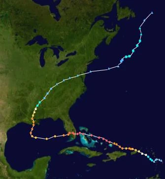
After a long bout of inactivity in the Atlantic, finally the first storm would come to form. Alberto was orginally invest 99l. The National Hurricane Centre gave a 70% chance of formation in the next 5 days, and 30 hours after their first advisory on the storm, Alberto was named as the first storm in 2024. The storm's convection had fully wrapped round the centre of circulation at this point. Alberto quickly intensified to a category 1 hurricane. Already Puerto Rico was getting a lot of rainfall from the storm, with up to 20mm on the south-western side of the island, and a hurricane warning was already in effect for the island, despite Alberto forecasted to make a closs pass-by. Alberto took just 12 hours to be called a category 2 hurricane, and soon enough, it became a category 3, and brought huge swaths of rainfall to Puerto Rico and BVI. It intesnified to a category 4, but briefly weakened to a category 3 due to an eyewall replacement cycle. However it quickly intensified back to category 4 status, and thanks to low wind shear, high sea surface tempature, high moisture and very high cyclone heat potential, the storm became a category 5. It gradually intensified and reached a peak intensity of 200mph (320kph) and a pressure of 978mb. It then made landfall in Miami with wind speeds of 195mph (315kph) and stalled there for 18 hours, before weakining to a category 4, and then a category 3. By this point it was now into the gulf of Mexico, and it started to intensify again, making a landfall near New Oreleans with winds of 150mph (240kph). The storm took a long time to weaken into a depression after landfall, compared to other storms which took only 6-18 hours to do so. Finally, on August 30th, the storm formed subtropical, but due to high wind shear, it lasted only 30 hours before turning extratropical.
Here is the track of the storm. From its beginning as a tropcial wave in the Lesser Antilles, to its end near Newfoundland.
Strongest Landfalls:[]
195mph, Miami
190mph, Nassau
180mph, Eleuthera
175mph, Cat Island
170mph, San Salvador Island
150mph, New Oreleans
100mph,Vieques
ACE: 59.355
Hurricane Beryl (September 1st - September 8th)[]
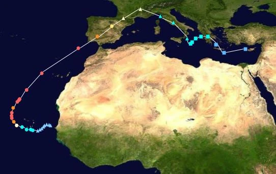
Beryl was a very strong Cape Verde hurricane which holds the record fot the most intense landfall in Europe by a tropcial cyclone at an intensity of 155mph (250kph) and a pressure of 926mb. Beryl formed near Africa, before then rapidly intensifying to category 5 status, peaking with winds of 175mph. However, it had a second peak after breifly weaking of 185mph. Beryl went on to hit spain, inflicting $67.2 billion in damages. Afterwards, Beryl turned extratropical and made its way through south-western Europe. On September 7th, it reformed subtropical, and struck Greece with winds of 50mph.
Strongest Landfalls:[]
155mph, Seville, Spain
60mph, Praia, Cape Verde
50mph, Preveza, Greece
ACE: 25.7425