| Category 5 major hurricane (SSHWS/NWS) | |
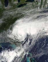
 Rene at peak intensity in the Western Caribbean | |
| Formed | November 13, 2020 |
|---|---|
| Dissipated | November 21, 2020 |
| (Extratropical after November 19) | |
| Highest winds | 1-minute sustained: 165 mph (270 km/h) |
| Lowest pressure | 902 mbar (hPa); 26.64 inHg |
| Fatalities | 107 Total |
| Damage | $27.01 billion (2017 USD) |
| Areas affected | Nicaragua, Honduras, Yucatan Peninsula, Cuba, United States, Bermuda |
| Part of the 2020 Atlantic hurricane season | |
Hurricane Rene was an extremely powerful tropical cyclone, and the strongest Atlantic hurricane ever recorded in the month of November. The seventeenth named storm, ninth hurricane, and fifth major hurricane of the annual season, Rene caused severe devastation in its path. The origins of Rene can be traced back to a trough that moved through the Atlantic in early November. A low was placed in the Caribbean, and it developed into a Tropical Depression on November 13. Intensifying into Tropical Storm Rene, it rapidly intensified in the Caribbean, and eventually struck the Florida panhandle as a Category 3 hurricane. Rene became extratropical on November 19.
The impacts of Hurricane Rene were widespread and catastrophic. The storm's precursor dropped heavy rains across Nicaragua and Honduras, killing several dozen people. And despite being spared the violent eyewall of Rene, Jamaica, the Yucatán Peninsula, and Cuba still got strong winds and rain. The southeastern United States, especially Florida, suffered destructive winds and heavy rainfall when the storm moved ashore as a Category 3 Hurricane. A large portion of the east coast received tropical storm force winds and rain. The remnants of Rene eventually caused disturbed weather across Europe.
Meteorological History[]

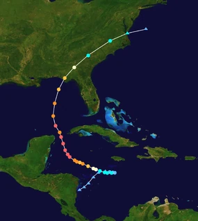
Map plotting the storm's track and intensity, according to the Saffir–Simpson scale
Tropical storm (39–54 mph, 63–87 km/h)
Category 1 (74–95 mph, 119–153 km/h)
Category 2 (96–110 mph, 154–177 km/h)
Category 3 (111–129 mph, 178–208 km/h)
Category 4 (130–156 mph, 209–251 km/h)
Category 5 (≥157 mph, ≥252 km/h)
A large area of disturbed weather began to persist over the southern Caribbean sea in early November, just east of Nicaragua. A couple days later, it began to interact with a trough, which resulted in increased convection and a decrease in wind shear. On November 9, the now-low pressure area began to move to the northeast in response to a low positioned in the Eastern Pacific, which almost became a tropical cyclone itself. At this time, the National Hurricane Center began to monitor the wave for potential development, noting fair conditions for development. On November 11, a burst of convection occurred, resulting in a low-level spin. Despite this, the cyclone did not develop further for another day or so. On November 13, a recon plane found a tight, quickly developing circulation. This prompted them to initiate advisories on Tropical Depression Eighteen, located southwest of Jamaica.
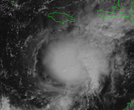
Tropical Storm Rene near hurricane status on November 15.
At the time, the newly formed Depression was forecast to become a moderate tropical storm and move over Haiti, so tropical storm watches were raised. Instead, the Depression initially moved due east, an unusual motion for a tropical cyclone. On November 14, a recon jet confirmed Eighteen had intensified into Tropical Storm Rene, although in post-analysis it was deemed Rene had already been a tropical storm for 6 hours. The fairly-organized cyclone didn't intensify much over the next several hours due to dry air in the area, causing fluctuations in intensity. However, by November 15, Rene was becoming much better organized, with an eye popping in and out of satellite imagery. Based on this, with dvorak claiming 65 kt winds, Rene was upgraded to a hurricane.
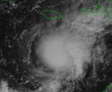
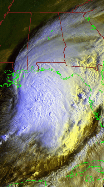
A very disorganized Hurricane Rene approaching the Florida Panhandle.
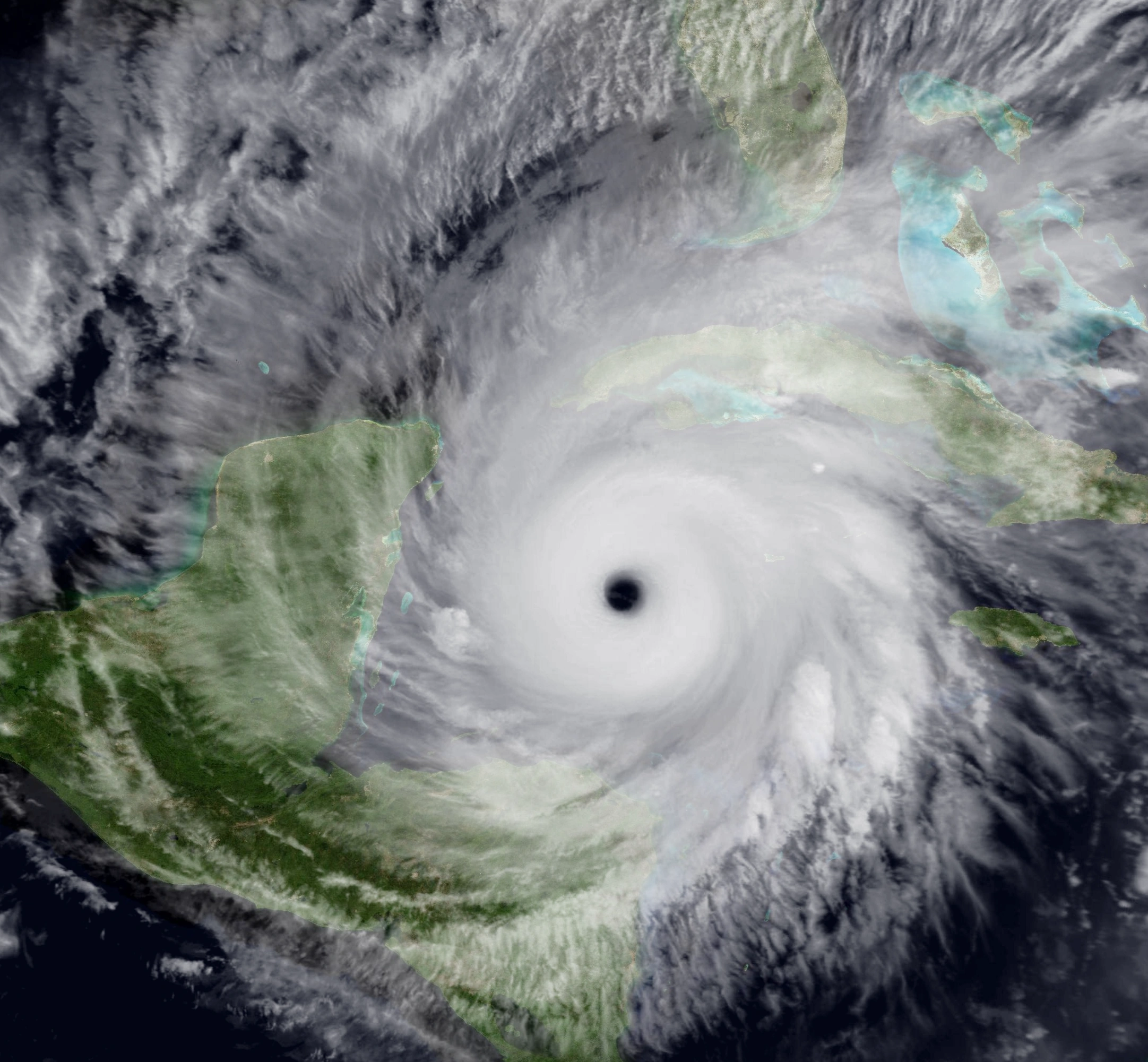
With decreasing shear and extremely warm and deep waters not touched since 2018, Rene began rapid intensification, as a well-defined eye emerged on satellite, becoming a major hurricane early on November 16, and the next morning, into a dangerous Category 5 hurricane, the first since Maria in 2017. This was only the second Category 5 hurricane ever recorded in November, after the 1932 Cuba Hurricane. Later that day, Rene reached peak intensity, with winds of 165 mph and a pressure of 902 millibars. Rene continued north into the Gulf of Mexico.

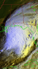
Tropical Storm Rene over the east coast on November 17.
Rene fluctuated between Category 4 and Category 5 status as it moved through the Yucatán channel. However, when Rene reached the Gulf, a sharp increase in wind shear caused a displacement of the convection, with the eyewall on the western edge of the convection. Rene weakened slowly but began to accelerate as it was picked up by a ridge. Rene's eyewall collapsed on November 18, causing a sharp decline in intensity. But that night, Rene made landfall in Panama City, Florida, as a minimal Category 3 hurricane with 115 mph winds. The storm's structure significantly degraded as it moved over Georgia, and it lost hurricane intensity as it moved over the Carolinas. As Rene moved off the coast of Virginia on November 19, it became post-tropical, and merged with the ridge that had picked it up.
Preparations & Impact[]
Haiti[]
When Rene was forecast to make landfall over Haiti, a tropical storm watch was raised and people began to prepare for the storm, as they put sandbags out front and bought supplies. However, when Rene began to move away from Haiti, life returned to normal. Rene caused little to no impacts in Haiti.
Mexico[]
People on the Yucatán Peninsula were told to prepare for Rene when the forecast had it just off the coast as a Category 4 Hurricane. Like Haiti, they took all the precautionary actions. The president told them to hunker down and prepare the worst.
In reality, Rene's core passed a couple dozen miles offshore, but tropical-storm force winds (gusting to hurricane force) and heavy rainfall were still present in Mexico. Landslides killed at least 25 people in Mexico, with more unaccounted for.
United States[]
When Rene was forecast to approach the United States, Americans along the coast of Alabama and western Florida were the initial threat. So these areas began to prepare for Rene. A group of people in Alabama dug out a giant moat for the floodwaters.
When Rene made landfall, catastrophic storm surge completely inundated some towns near the landfall point. This included Panama City, one of Florida's biggest cities.
Rescue Operations In The United States[]
The timing of Rene's landfall in the United States was very inconvenient, as sea surface temperatures were much colder than normal during the hurricane season. Combined with a cold front having passed over Florida only days earlier, temperatures in Florida were roughly 51 degrees Fahrenheit when the storm made landfall, and Rene only made it colder. A reading of 38 degrees was recorded in Tampa, Florida. Due to this, the waters and rain were very cold, which caused severe cases of hypothermia across the landfall zone. At least half of Rene's U.S fatalities can be blamed on hypothermia. Due to this, rescue operations were much slower as the rescuers had to be more precise, as to not risk falling into the frigid waters.
Retirement[]
Due to the extreme devastation in Florida, the once-in-a-lifetime cold event, and partially due to the exceptional intensity, the name Rene was retired at the WMO conference in April 2021. The name Ryan was chosen to replace it for 2026.