The 2023 Atlantic hurricane season was an event in annual tropical cyclone season in the Atlantic Ocean. The season had an average number of storms, totaling 12 tropical storms including eight hurricanes and a single major hurricane.
Storms[]
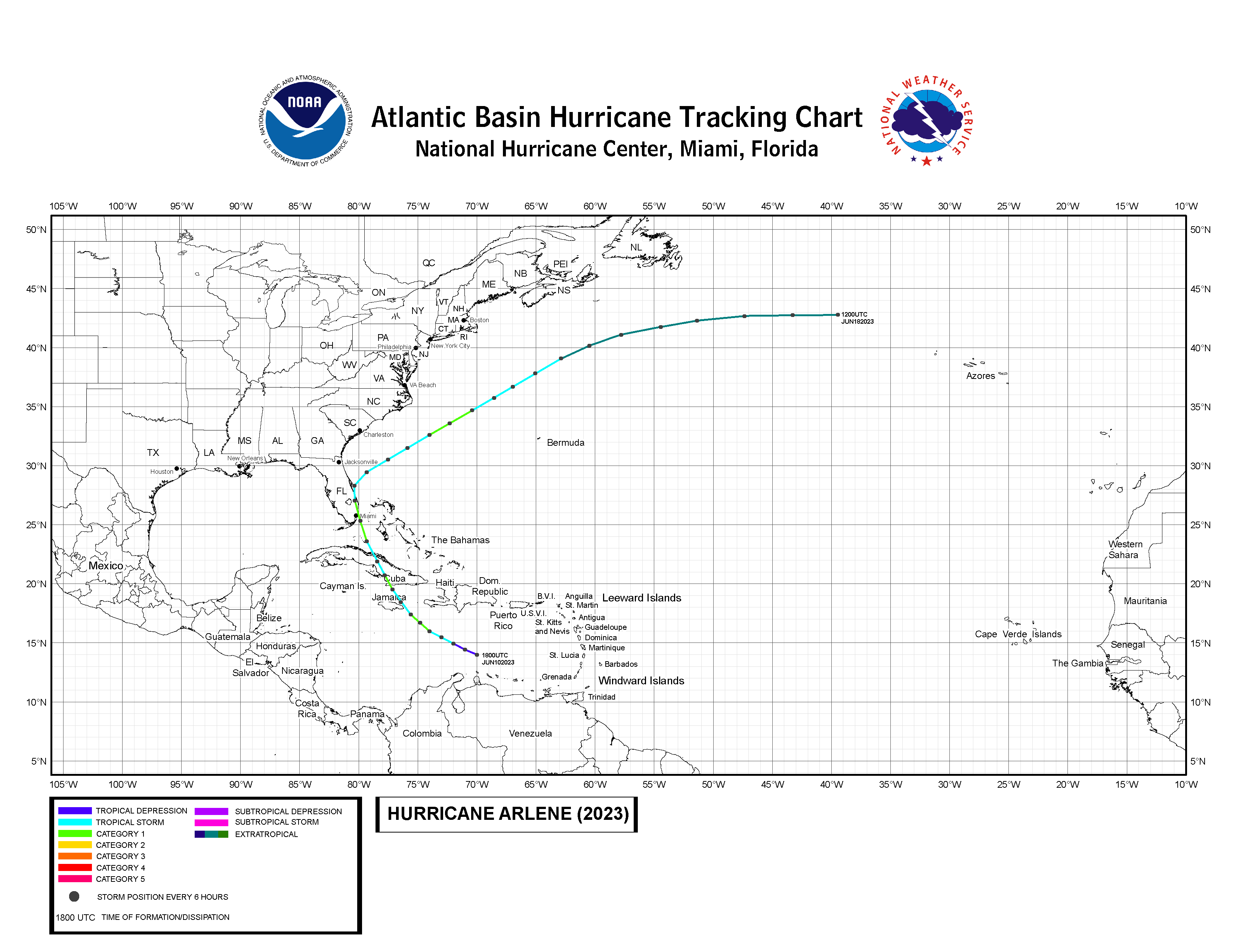
Hurricane Arlene[]
| Category 1 hurricane (SSHWS) | |
  | |
| Duration | June 10 – June 16 |
|---|---|
| Peak intensity | 85 mph (135 km/h) (1-min) 988 mbar (hPa) |
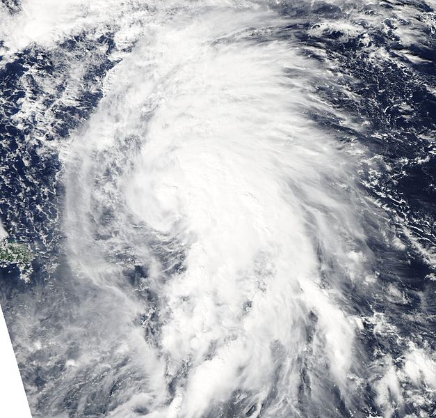
Hurricane Arlene originated as a tropical low, which developed from a tropical wave on early June. The low developed to Tropical Depression One over the Caribbean Sea on June 10. The system was upgraded to Tropical Storm Arlene the next day. Then, it strengthened to a hurricane as it neared Jamaica. The storm bypassed the island on June 12, and due to interaction with the rugged terrain of it and Hispaniola, Arlene weakened. Later that day, Arlene briefly strengthened to a hurricane before striking Cuba several miles east of Cabo Cruz. Its passage through the island caused another weakening phase of the storm. However, soon after emerging over the Atlantic, Arlene re-strengthened, peaking as a 80MPH storm before striking Florida near Miami late on June 13. The storm weakened again over Florida, but an upper-level trough pulled Arlene northeastwards into the Atlantic. Although wind shear increased gradually, it regained hurricane strength for the last time on June 15. The storm moved to cooler waters, weakened, and then transitioned to an extratropical cyclone. The remnant system would last until June 18, when it merged with an Arctic front over the Atlantic.
In Jamaica, heavy rains caused landslides and floods throughout the island. Infrastructural damage in the island was estimated to be at $8.5 million (2023 USD). Seven deaths were reported due to landslides and drowning from floods. The island almost recovered from an economic crisis after World War 3, but the storm caused crop damage up to $7 million (2023 USD) and cattle deaths. As a result, meat and vegetable prices were much higher than during the war. Neighboring Hispaniola also suffered similar impact from the storm, although due to advanced warning system, no deaths were reported and damage was estimated at 1.7 million (2023 USD). In Cuba, unpreparedness due to a civil war at the time caused riots and panics. Warnings were all placed, but very few people took shelter and instead some looted markets for supplies during the storm. In spite of the unpreparedness, only two deaths were reported. However, damage soared up to $15 million (2023 USD). Florida and the Bahamas fared well during the storm, but damage in Florida was totaled at $32 million (2023 USD). In total, 11 people died from the storm (7 from Jamaica, 2 from Cuba, 1 from Florida, and 1 from the Bahamas) and damage was estimated at $64.2 million (2023 USD).
Tropical Storm Bret[]
| Tropical storm (SSHWS) | |
  | |
| Duration | July 10 – July 15 |
|---|---|
| Peak intensity | 70 mph (115 km/h) (1-min) 993 mbar (hPa) |
Tropical Storm Bret formed from a tropical wave on July 10 over the Eastern Caribbean Sea. The system, formed as a depression moved due west-northwestwards for most of its life. Bret was upgraded to a tropical storm on early July 11, based on reconnaissance aircraft data. The storm strengthened over warm waters, peaking as a 70MPH storm, almost reaching hurricane strength. However, the storm weakened due to dry air inundation on its center on July 13 while passing south of Jamaica. The next day, Bret was downgraded to a depression after satellite imagery showed convection displaced to the eastern side of the circulation. The system dissipated on July 15 while located south of Cuba. The remnant low erratically turned towards the south, and dissipated off the coast of Belize the day after it was no longer a tropical cyclone.
Throughout the passage of the storm, riptides were reported in most of the Antillean Islands, Northern South America, and Central America. Beaches were closed in these areas as a precaution to prevent death. Even so, a lightning strike in Kingston, Jamaica killed a man while fixing his car. As a tropical cyclone, Bret caused only one death and minor damages. However, its remnant almost regenerated while landing on the coast of Belize, causing landslides and floods from heavy downpours, ultimately resulting in damage up to $500,000 (2023 USD).
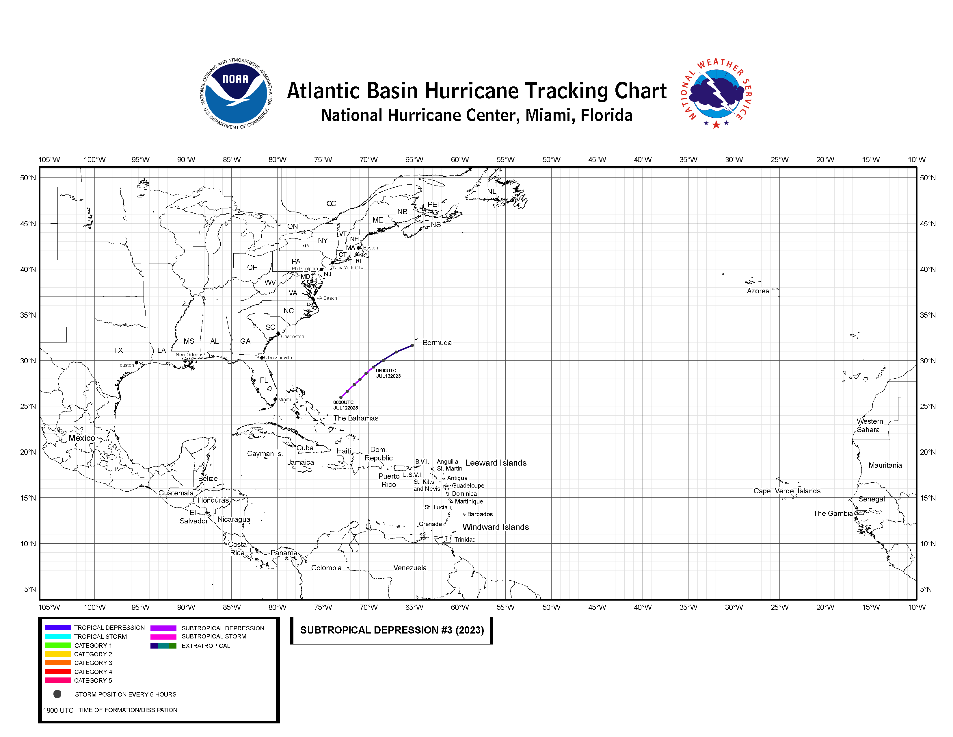
Subtropical Depression Three[]
| Subtropical depression (SSHWS) | |
  | |
| Duration | July 12 – July 13 |
|---|---|
| Peak intensity | 30 mph (50 km/h) (1-min) 1000 mbar (hPa) |
The short-lived depression formed on July 12 from a tropical wave east the Bahamas. The wave interacted with a cold front, causing a broad circulation to form late on July 11. The circulation became organized enough the next day to be classified as a subtropical depression. The system tracked northeastwards, and although moving over warm waters, it did not have a sign of intensification due to high wind shear. On July 13, the system merged with the cold front that attached to it. The remnants affected Bermuda before transforming into a devastating extratropical cyclone.
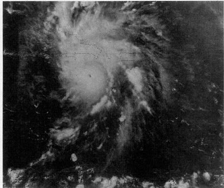
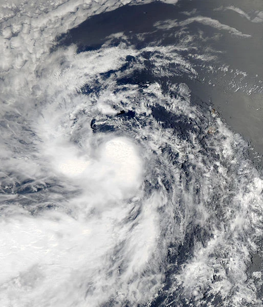
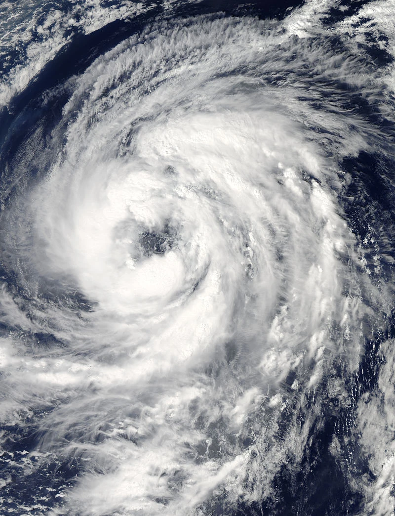
Hurricane Cindy[]
| Category 1 hurricane (SSHWS) | |
  | |
| Duration | August 3 – August 14 |
|---|---|
| Peak intensity | 90 mph (145 km/h) (1-min) 980 mbar (hPa) |
A tropical wave exited the African coastline on early August. The wave had disorganized, but strong complex of convection. It gradually organized and was upgraded to Tropical Depression Four on August 3 over the Central Atlantic. The depression strengthened to a tropical storm six hours after being classified. Cindy strengthened to a hurricane late on August 5. The storm's wind speed fluctuated while maintaining category 1 strength due to variation in wind shear. Cindy peaked as a 90MPH storm on August 10 before striking Haiti near Les Cayes later that day. Crossing the rugged terrain of Haiti, the storm weakened to a tropical storm following landfall. The next day, still at tropical storm strength the storm struck Cuba near San Antonio del Sur. Cindy regained hurricane strength on August 12 while crossing over the Bahamas. On August 13, however, the storm weakened again due to the westerly winds while tracking northeastwards. Cindy eventually transformed to an extratropical cyclone late on the next day due to increased consumption of dry air.
The storm made landfall on Barbados, causing immense damage to the island. Hurricane-force winds snapped down electrical lines and heavy rains caused flooding in much of the island. The eye of the storm scraped the northern coast of St. Vincent. Similarly, immense damage also occurred in the island. As a result, an economic crisis occurred on both islands soon after the storm. In Haiti, damage totaled up to $75 million (2023 USD) from mudslides and extensive floods. Similarly, the country suffered an economic crisis after the storm. There was minor damage in Cuba and one death was reported. While over the Atlantic, the storm produced riptides all over the Eastern Seaboard, but no deaths were reported. In total, Cindy caused damage up to $101 million (2023 USD) ($75 million in Haiti, $16 million in the Leeward Islands, $5 million in Dominican Republic, $3 million in Jamaica, $1.5 million in the Bahamas, and $500,000 in Cuba.) Eight deaths were reported.
Tropical Storm Don[]
| Tropical storm (SSHWS) | |
  | |
| Duration | August 8 – August 11 |
|---|---|
| Peak intensity | 45 mph (70 km/h) (1-min) 996 mbar (hPa) |
Tropical Storm Don was first identified as a tropical wave on early August. The wave organized to a tropical depression on August 8 to the southwest of Cape Verde Islands. The system strengthened to a tropical storm the next day while tracking generally west-northwestwards. There was little strengthening expected, because to the west and north of the storm were dry air and high wind shear. Don turned to the southwest on August 10 and then weakened to a tropical depression. On August 11, aircraft reconnaissance drones reported an open circulation. As a result, it was no longer a tropical cyclone. The remnant low still lingered in the Atlantic for a few days. No damage or deaths were reported.
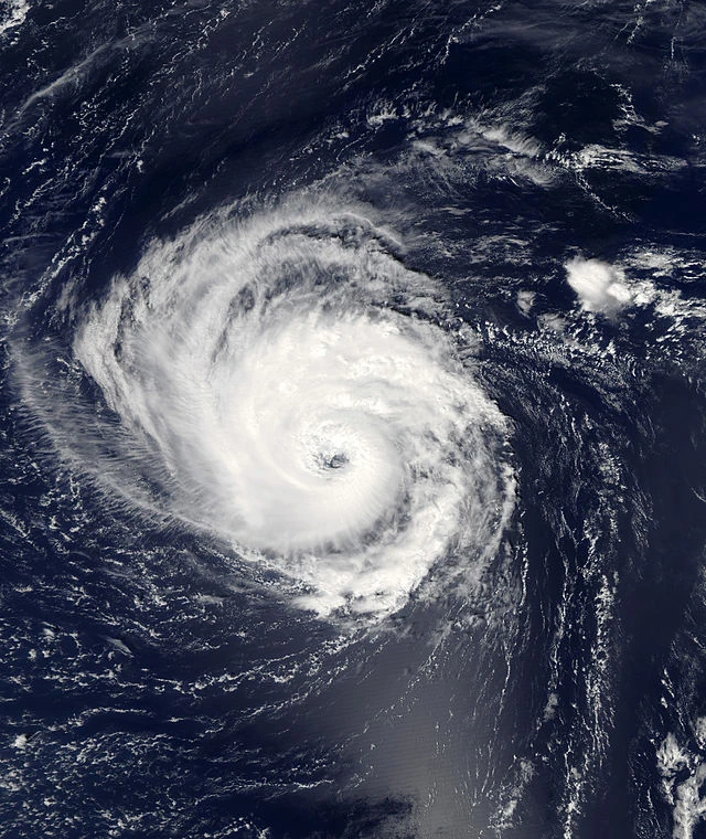
Hurricane Emily[]
| Category 1 hurricane (SSHWS) | |
 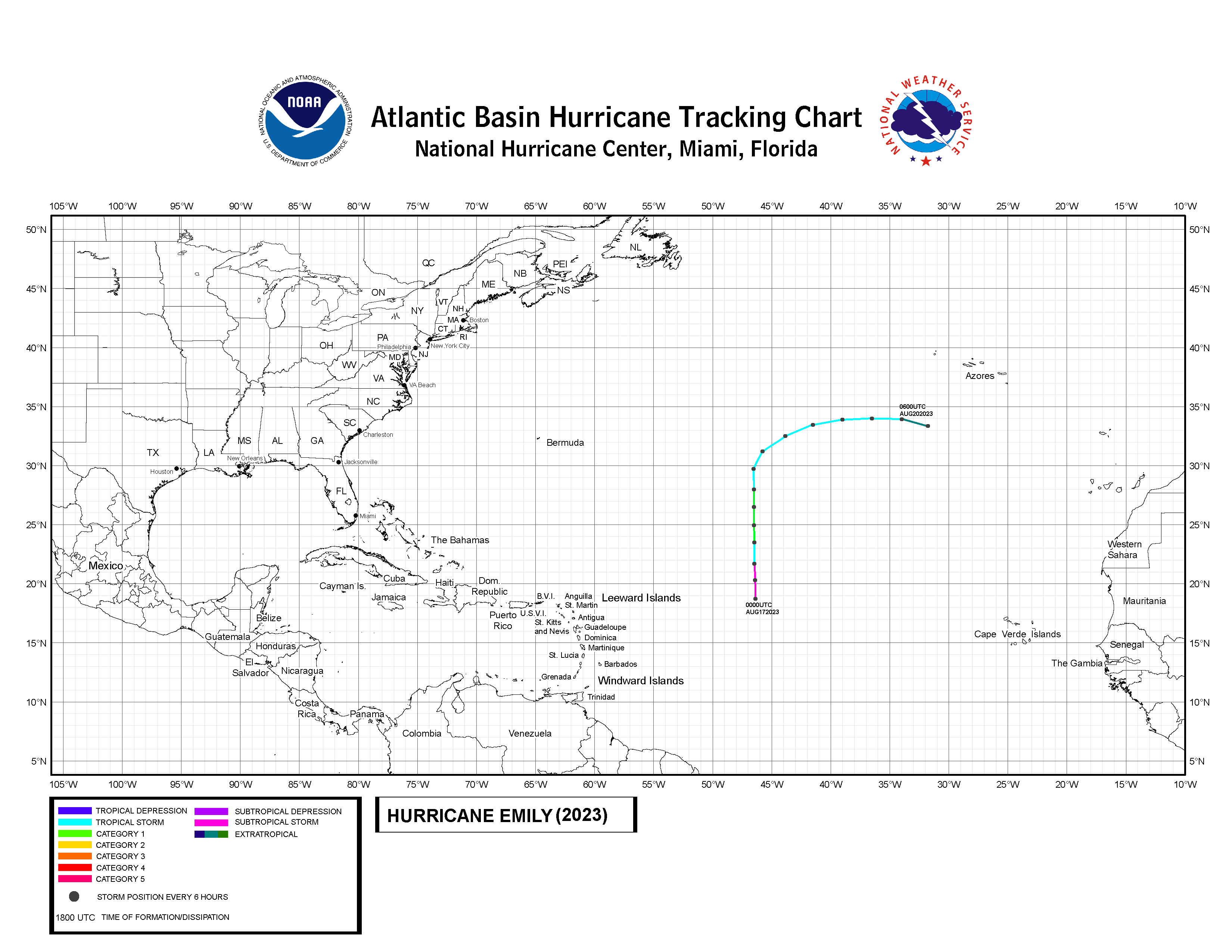 | |
| Duration | August 17 – August 20 |
|---|---|
| Peak intensity | 80 mph (130 km/h) (1-min) 960 mbar (hPa) |
In the wake of Tropical Storm Don, a large disturbance developed from a tropical wave and a monsoon-like trough over the Eastern Atlantic. Moving westwards, a combination of the disturbance and a cold front caused an extratropical cyclone to form on August 15. With wind shear decreasing, the system consolidated to Subtropical Storm Emily two days later. The storm tracked northwards throughout most of its life. Emily deepened to a tropical storm later on August 17 and shortly after, strengthened to a hurricane. The storm was as large as a typhoon, so its minimum pressure was abnormally low for other storms of its strength. Emily dropped strength late on August 18 because of increasing wind shear and dry air. Its track was bent to the northeast on the next day and posing a threat to the Azores. However, the storm merged with a stationary front to the south of the islands.
Because of its large size, Emily produced high riptides all over the Eastern Seaboard. Damage was light and no deaths were reported. In Azores, similar conditions were felt, but not as it would be anticipated. No damage or deaths were reported.
Hurricane Franklin[]
| Category 2 hurricane (SSHWS) | |
  | |
| Duration | September 1 – September 11 |
|---|---|
| Peak intensity | 105 mph (170 km/h) (1-min) 972 mbar (hPa) |
A tropical wave developed to Tropical Depression Seven on September 1 over the Central Atlantic. Taking a track similar to Hurricane Edouard (2014), the depression headed northwestwards and strengthened to a tropical storm six hours after forming. Franklin turned to the west on September 3, before turning back to the northwest the next day. During this period, the storm strengthened to a hurricane. The storm was forecast to strengthen into an intense storm, but wind shear kept delaying intensification. As a result, Franklin only peaked as a 110MPH storm with a pressure of 972 mbar. The storm turned to the northeast on September 7 and began weakening. It wasn't until September 9, however, when the storm was downgraded to a tropical storm. Franklin soon turned to the southeast, weakened to a tropical depression, and dissipated on September 11.
A riptide injured a surfer in Long Island, New York. No damages were reported.
Hurricane Gert[]
| Category 2 hurricane (SSHWS) | |
  | |
| Duration | September 11 – September 23 |
|---|---|
| Peak intensity | 105 mph (170 km/h) (1-min) 975 mbar (hPa) |
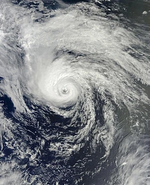
The subtropical ridge strengthened causing it to bump the tropical waves southwards. One of these waves developed into Tropical Depression Eight on September 11. Forming at similar latitudes as Hurricane Ivan (2004), the depression moved on an almost straight direction to the west. It strengthened to Tropical Storm Gert on the day after its formation. On September 14, Gert strengthened to a hurricane, the fifth of the season. Strengthening was hindered by a series of upper-level lows. As a result, Gert only peaked in strength as a moderate category 2 hurricane with winds of 105MPH. However, the storm weakened to a low-end category 1 hurricane on September 21, before striking land near Mabaruna, Suriname. Combined with wind shear, Gert weakened rapidly over land. The storm emerged over the Caribbean Sea on September 23, but dissipated soon after.
Gert held the record as the southernmost North Atlantic hurricane landfall. In Suriname, heavy rains contributed to floods, mudslides, and destruction of several coastal villages. Because there was no formal tropical cyclone warning in the country, deaths were estimated as high as 71 people, but there was lack of data about the damage count. Venezuela, although suffering extensive damage, fared well during the storm. Only one person died because of early precautions and being one of few South American countries to have formal tropical cyclone warnings. The country, still recovering from the economic impact of World War 3 almost collapsed and a civil war occurred. Damage in the country was totaled at $100 million (2023 USD).
Tropical Storm Harvey[]
| Tropical storm (SSHWS) | |
 | |
| Duration | September 25 – September 28 |
|---|---|
| Peak intensity | 50 mph (80 km/h) (1-min) 992 mbar (hPa) |
A tropical wave emerged from the African coast following Hurricane Gert. After speeding westwards on the southern edge of the subtropical ridge, the wave developed to Tropical Storm Harvey on September 25 near the Leeward Islands. Little strengthening took place because dry air inundation and moderate wind shear. Throughout most of its life, Harvey's center was exposed at times. The storm initially tracked northwestwards, but turned to the northeast on September 27 due to a cold front. After persisting at tropical storm strength, Harvey weakened to a tropical depression on September 28 and then dissipated.
The storm poured rains as high as six inches in the Virgin Islands. Little flooding took place, however, because there was no rainfall in the previous one month. In Bermuda, squally conditions and coastal flooding took place. A woman died when a large electrical pole fell on her. No damages were reported.
Hurricane Irma[]
| Category 1 hurricane (SSHWS) | |
 | |
| Duration | October 1 – October 5 |
|---|---|
| Peak intensity | 80 mph (130 km/h) (1-min) 983 mbar (hPa) |
Hurricane Irma originated from a tropical wave, which exited the African Coast on late September. The wave stalled over the Lesser Antilles, gradually organizing to a tropical depression on October 1 over the Eastern Caribbean Sea. The depression strengthened the next day to Tropical Storm Irma. As a moderate storm, it struck Puerto Rico later on October 2. Land interaction dropped its winds from 60MPH to 40MPH, along with very dry air on its west. Although disrupted, the storm reorganized over warm waters of the Atlantic. Irma reached hurricane strength for the first time on October 3 as it turned to the northeast. Irma then accelerated, peaking as an 80MPH storm with pressure of 983 mbar and a deformed eye. However, the storm then dropped below hurricane strength later that day. Wind shear made a sharp and gradual increase, causing dry air to be blown into the storm. On October 4 however, reconnaissance aircraft data showed that Irma regained hurricane strength, although its appearance was disfigured. This was held for a short time, and the next day, it weakened further and transformed into an extratropical cyclone. The system eventually merged with a stationary front near Newfoundland on October 6.
The storm caused damage up to $11 million (2023 USD) of damage in Puerto Rico. In San Juan, a mesoscale vortex damaged two buildings and a cruise ship. Landslides and flash floods damaged roads and isolated many settlements. Fortunately, no deaths occurred because of advanced warning systems and online information of the storm. Although in Caguas, a man nearly drowned when floodwater swept his car into a river.
Tropical Storm Katia[]
| Tropical storm (SSHWS) | |
 | |
| Duration | October 9 – October 12 |
|---|---|
| Peak intensity | 50 mph (80 km/h) (1-min) 991 mbar (hPa) |
A small tropical disturbance formed from a tropical wave in the Caribbean Sea in early October. The disturbance organized to Tropical Depression Eleven on October 9 while located southwest of Jamaica. The system tracked due northwestwards, strengthening little due to the wind shear. On October 11, the storm managed to strengthen into a tropical storm while approaching Cuba. However, Katia weakened to a tropical depression the next day and dissipated soon after.
Squally conditions, floods, and landslides occurred in Jamaica. In Little London, a girl died when an electrical pole fell onto her house. In nearby town of Savanna la Mar, a bus was found floating at sea, possibly swept by a storm surge. Officials investigating it found seven corpses inside of it. Because of its small size, its rains were not felt in the Cayman Islands, but a female surfer died there from a riptide. In Cuba, the storm was reported making landfall near Cabo Cruz. The southern part of the island suffered flash floods and strong winds. Eight deaths were reported in the Turquino National Park. The victims were among the anti-government rebels hiding in the park.
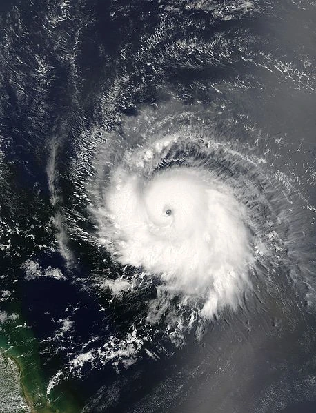
Hurricane Jose[]
| Category 3 hurricane (SSHWS) | |
 | |
| Duration | October 10 – October 21 |
|---|---|
| Peak intensity | 115 mph (185 km/h) (1-min) 956 mbar (hPa) |
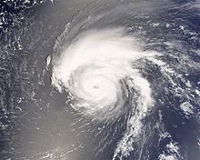
A tropical wave organized to Tropical Depression Twelve late on October 10 east of the Windward Islands. The system tracked west-northwestwards and strengthened to Tropical Storm Jose twelve hours after being classified. Although within warm waters and low wind shear, dry air inhibited strengthening for the next few days. On October 13, Jose entered a region with moist air, permitting it to strengthen. The next day, the storm gained hurricane strength to the south of Bermuda. Then, steering currents were disrupted by an approach of a cold front, causing Jose to slow down. The storm strengthened further to a category 2 storm on October 15 while turning to the east-northeast. After that, Jose executed a clockwise loop near Bermuda and then strengthened to a category 3 storm, the first and only in the season. Simultaneously, the storm reached its peak strength as a 115MPH storm with a pressure of 956 mbar. However, the storm's erratic passage caused waters to cool down. Jose began a weakening trend on late October 16 as it departed Bermuda. The storm was below hurricane strength by October 17. Weakening was aided with wind shear and dry air. Jose still moved over warm waters, averaging 28 degrees Celcius, but wind shear and dry air did not permit strengthening. By late October 19, wind shear and dry air diminished, and Jose began another strengthening phase as its track shifted north-northeastwards. The storm regained hurricane strength that day and gained a secondary peak intensity as a 100MPH storm on October 20. However, wind shear increased again, causing the storm to weaken once more. On October 21, the storm lost hurricane strength and later transformed into a low-pressure area.
People living in Bermuda were practically unprepared because the storm approached much closer than predicted. When it strengthened to a category 3 hurricane, Bermudians were given precautions about damage and dangers that the storm would bring. However, damage was lighter than expected, because the storm turned away before hitting the island. Squally conditions occurred in 3/4 part of the island, the rest only suffer light winds. Damage in Bermuda totaled $500,000 (2023 USD).
Hurricane Lee[]
| Category 1 hurricane (SSHWS) | |
 | |
| Duration | October 25 – October 29 |
|---|---|
| Peak intensity | 75 mph (120 km/h) (1-min) 990 mbar (hPa) |
A tropical wave consolidated over the Caribbean Sea on mid-October. The wave tracked due northwards, passing over Hispaniola, and causing its convection to become shredded apart. When it emerged over the Atlantic, convection re-consolidated and there was a possibility of becoming a tropical cyclone within the next few days. However, the system merged with an extratropical storm over Bermuda soon after. The cyclone tracked southwestwards and then deepened over the Gulf Stream. On October 25, it spawned a subtropical depression off the coast of Florida. Lee remained weak due to wind shear for the first two days of its life. However, wind shear gradually relented, allowing it to strengthen into a subtropical storm on October 27. Later, the storm deepened to a fully tropical cyclone as it turned towards the northwest. Lee turned to the southwest, then south, and later southeast. The storm strengthened to a hurricane before merging with a nor'easter.
In Cape Hatteras, North Carolina waves were reported as high as four meters. In the surrounding area, severe beach erosion occurred, causing minimal damage.
Tropical Depression Fourteen[]
| Tropical depression (SSHWS) | |
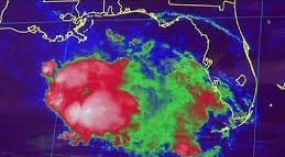 | |
| Duration | November 1 – November 3 |
|---|---|
| Peak intensity | 30 mph (50 km/h) (1-min) 1000 mbar (hPa) |
A tropical disturbance, spawned by Intertropical Convergence Zone (ITCZ), developed to a tropical depression east of the Yucatan Peninsula very early on November 1. The storm tracked north-northwestwards, with its rainbands pouring rains in Western Cuba and Yucatan Peninsula. A dip in the jet stream caused it to turn towards the north-northeast towards Florida while over the Gulf of Mexico. Tropical storm warnings were initiated from Dry Tortugas to Pensacola, but the depression dissipated early on November 3 without making landfall. Severe floods occurred in Cuba, causing moderate damage to the capital city of Havana. In Cuba, damage was estimated at $20 million (2023 USD), but nowhere else suffered damage from the storm. Deaths were mostly caused by people, not by the storm. Before the storm arrived, citizens stampede into shops and markets to take supplies. The resulting stampede caused 21 deaths and left two missing.
Storm Names[]
This is the same list of name used in 2017, with the exception of Matilda and Tasha, which replaced Maria and Tammy in 2017, respectively.
|
|
|
Retirement[]
The name Gert was retired due to prolonged effects in Suriname and Venezuela. The name was replaced with the name Gwen.