The 2015 Atlantic hurricane season was a slightly above average season that featured a few intense systems. The season began on June 1, 2015, and it ended on November 30, 2015, dates of which conventionally delimit the period of each year when most tropical cyclones form in the Atlantic basin. Overall, the 2015 Atlantic hurricane season produced 14 tropical cyclones, of which 13 developed into tropical storms; seven storms attained hurricane intensity, and three hurricanes further reached major hurricane status. The activity in this season was slightly above average, with 13 storms. The strongest storm of the season was Hurricane Erika, which reached Category 5 intensity on the Saffir-Simpson Hurricane Scale in the Caribbean Sea. The storm caused devastation throughout the Caribbean and the U.S. The name was later retired and replaced by Erma for the 2021 season.
The season began with the formation of Tropical Storm Ana on June 25 and ended with the dissipation of Subtropical Depression Fourteen on December 6. In late August to early September, Erika tracked through the Caribbean and the Gulf of Mexico as a Category 5 hurricane, later making landfall in Texas as a Category 2 hurricane. It caused major damage to many of the Caribbean islands and in Texas. In addition, Hurricane Joaquin struck the Yucatan Peninsula as a Category 1, peaked as a Category 2 over the Gulf of Mexico, and struck Texas as a Category 1, causing plenty of damage. The name wasn't retired. Also, Ana affected Florida as a TS, Claudette was a TS that struck Mexico, Ida struck Florida as a TS, Kate struck the Gulf Coast of Florida as a TS, and Larry was a TS that affected the Yucatan Peninsula, Cuba, and Florida. However, the above storms were not nearly as damaging as Erika.
Season summary[]
June[]
The season started with Tropical Storm Ana, which formed on June 25 and dissipated on June 30. It affected the Yucatan Peninsula and Florida. No other storms formed in June.
July[]
No storms formed in July, making it the first time since 2012 this happened.
August[]
The season got more active in August, and 4 storms formed in the month: Bill, Claudette, Danny, and Erika. Bill was a Category 3 Cape-Verde type hurricane that didn't affect land. Claudette was a tropical storm that affected Mexico. Danny was a Category 2 that first formed as a tropical storm, then degenerated, and then regenerated southwest of Bermuda and strengthened into a Category 2 as it moved northeastward. Danny didn't affect land. Finally, Erika was a huge Category 5 hurricane that raged through the Caribbean and the Gulf of Mexico, later making landfall in the U.S; causing major damage and lots of deaths. Erika crossed over to September.
September[]
The month began with Erika raging through the Caribbean. Later in the month, 4 storms formed: Fred, Grace, Henri, and Ida. Fred was a weak tropical storm that didn't affect land. Grace was a Category 1 hurricane that affected the Bahamas as a developing depression and also caused slight affects in Bermuda. Henri was a Category 4 Cape-Verde type hurricane that only affected the Cape Verde Islands as a developing tropical storm. Finally, Ida was a tropical storm that affected Florida and the Carolinas, and it also crossed over into October.
October[]
The month began with Ida near Florida. Later in the month, 3 storms formed: Joaquin, Kate, and Larry. Joaquin was a Category 2 that affected Nicaragua and Honduras as a tropical storm, the Yucatan Peninsula as a Category 1, and Texas as a Category 1 (after peaking as a Category 2 over the Gulf of Mexico). It caused some damage throughout its path. Kate was a weak tropical storm that hit Florida. Finally, Larry was a tropical storm that affected Nicaragua and Honduras while developing; and the Yucatan Peninsula, Cuba, and Florida as a TS, and the Bahamas as a TD.
November[]
November had only 1 storm, Mindy. Mindy was a Category 1 hurricane that affected Bermuda as a tropical storm, and later peaked in open waters.
December[]
Finally, after the season had ended, a subtropical depression formed on December 5 north of the Lesser Antilles. It moved westward without strengthening and dissipated the next day. It didn't affect land.
Overall, this season was an active one, although only slightly above average.
Seasonal forecasts[]
| Source | Date | Named storms |
Hurricanes | Major hurricanes | |
| Average (1981–2010) | 12.1 | 6.4 | 2.7 | ||
| Record high activity | 28 | 15 | 8 | ||
| Record low activity | 4 | 2 | 0† | ||
| ––––––––––––––––––––––––––––––––––––––––––––––––––––––– | |||||
| TSR | December 7, 2014 | 12 | 5 | 2 | |
| WSI | December 21, 2014 | 14 | 7 | 3 | |
| CSU | April 4, 2015 | 13 | 6 | 2 | |
| TSR | April 12, 2015 | 11 | 5 | 2 | |
| TWC | April 24, 2015 | 10 | 4 | 1 | |
| TSR | May 23, 2015 | 11 | 5 | 2 | |
| UKMO | May 24, 2015 | 12* | N/A | N/A | |
| NOAA | May 24, 2015 | 9–14 | 3–7 | 0–3 | |
| FSU COAPS | May 30, 2015 | 8-13 | 3-6 | N/A | |
| CSU | June 1, 2015 | 12 | 6 | 2 | |
| TSR | June 6, 2015 | 13 | 7 | 3 | |
| NOAA | August 9, 2015 | 8–13 | 3–7 | 0-3 | |
| ––––––––––––––––––––––––––––––––––––––––––––––––––––––– | |||||
| Actual activity |
13 | 7 | 3 | ||
| * June – November only: 16 storms observed in this period. † Most recent of several such occurrences. () | |||||
Timeline[]

List of storms[]
Tropical Storm Ana[]
| Tropical storm (SSHWS) | |
  | |
| Duration | June 25 – June 30 |
|---|---|
| Peak intensity | 65 mph (100 km/h) (1-min) 993 mbar (hPa) |
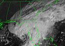
On June 23, the National Hurricane Center began to monitor an area of disturbed weather in the western Caribbean with a low chance of development, saying that gradual development was possible. It got better organized as it moved westward, and by the next day, it had a medium chance of development. On June 25, the disturbance became Tropical Depression One, while just east of the Yucatan. It was upgraded to a tropical storm and was named Ana twelve hours later, while making landfall on the tip of the Yucatan. The landfall was brief however, and Ana emerged into the Gulf of Mexico just six hours after landfall. After emerging into the Gulf, the NHC forecasted Ana to gradually strengthen, and eventually make landfall in Florida. Ana gradually strengthened as it was predicted, and early on June 28 it reached its peak intensity of 65 mph and 993 mbar. By that time, tropical storm warnings were up for most of the Gulf Coast of Florida. Ana made landfall in northwestern Florida at 8 P.M. on June 28, causing lots of rain and flooding. It weakened as it crossed Northern Florida, and briefly emerged into the Atlantic on June 29 as a tropical depression. The weakened Ana made a second landfall in South Carolina, and the last advisory was issued at 2 A.M. on June 30. Its remnants continued moving up the east coast, bringing heavy rain along the way. Overall, Ana caused $306 million dollars in damage (2015 USD) and 8 deaths throughout its path.
Hurricane Bill[]
| Category 3 hurricane (SSHWS) | |
  | |
| Duration | August 7 – August 14 |
|---|---|
| Peak intensity | 120 mph (195 km/h) (1-min) 960 mbar (hPa) |
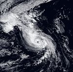
After an unusual, inactive July, a strong tropical wave moved off the coast of Africa on August 3. Initially disorganized, it gradually became more organized as it moved westward across the Atlantic. On August 5, it was given a low chance of development by the NHC. The wave had a high chance of development on the night of August 6, and it became organized enough to be declared Tropical Depression Two on August 7 while in the central Atlantic. Six hours later, the depression was upgraded to Tropical Storm Bill. The NHC predicted Bill to gradually intensify under favorable conditions. As it moved northwestward, Bill strengthened, and became a hurricane on August 9. Continuing to strengthen, it reached Category 2 intensity on August 10 and Category 3 intensity that night. Bill reached its peak intensity of 120 mph and 960 mbar on August 11 while hundreds of miles east of Bermuda. After that, cooler waters began to weaken Bill, and it weakened into a Category 2 that night as it turned northeastward. Continuing to weaken, it was downgraded to a Category 1 late on August 12 and a tropical storm early on August 14. The last advisory on Bill was issued later that day as it became extratropical. Its extratropical remnants were eventually absorbed near Greenland. Bill didn't affect land, so no damage or deaths were caused by the storm.
Tropical Storm Claudette[]
| Tropical storm (SSHWS) | |
  | |
| Duration | August 13 – August 15 |
|---|---|
| Peak intensity | 50 mph (85 km/h) (1-min) 996 mbar (hPa) |
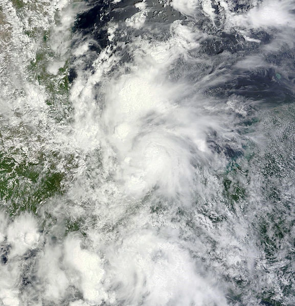
The National Hurricane Center began to monitor an area of disturbed weather over the Yucatan on August 11. It had a low chance of development at first, but once it emerged into the Bay of Campeche, it entered more favorable conditions. On August 12, the disturbance had a medium chance of development. Soon it had a high chance of development, and it was upgraded to Tropical Depression Three on August 13. Six hours later, the depression was upgraded to a tropical storm and named Claudette. Claudette moved westward through the Bay of Campeche, and gradually strengthened. On August 14, it reached its peak of 50 mph and 996 mbar before making landfall near Veracruz at 2 A.M. on August 15. Claudette quickly weakened over land before dissipating later that day. It caused $43 million dollars in damage (2015 USD) and 14 deaths throughout its path.
Hurricane Danny[]
| Category 2 hurricane (SSHWS) | |
  | |
| Duration | August 18 – August 28 |
|---|---|
| Peak intensity | 105 mph (165 km/h) (1-min) 971 mbar (hPa) |
A tropical wave rolled off the coast of Africa on August 15. It gradually developed as it moved eastward, and it had a high chance of development late on August 17. On August 18, it became organized enough to be declared Tropical Depression Four. The depression strengthened into a tropical storm twelve hours later and was named Danny. Danny moved eastward through slightly favorable conditions, and reached its first peak of 50 mph and 997 mbar early on August 20. However, wind shear began affecting the tropical cyclone, causing it to weaken. On August 21, it degenerated into a tropical wave hundreds of miles northeast of the Lesser Antilles. The NHC monitored the remnants of Danny for possible redevelopment as it moved slowly eastward across the open Atlantic. On August 22, it had a low chance of redevelopment, but on August 23, it got better organized and it had a high chance of redevelopment. It regenerated into a depression that night, and strengthened back into a tropical storm twelve hours later. Danny turned northward, and very favorable conditions allowed it to strengthen into a hurricane late on August 25 east of Bermuda. Danny became a Category 2 the next day as favorable conditions persisted and it turned northeast, and reached its peak of 105 mph and 971 mbar early on August 27. After that, however, it entered cooler waters and increasing wind shear, which began its weakening. Danny weakened into a Category 1 that night, and further weakened into a tropical storm before dissipating on August 28 south of Newfoundland. Danny didn't cause any damage because it didn't affect land.
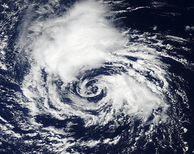
Hurricane Erika[]
| Category 5 hurricane (SSHWS) | |
  | |
| Duration | August 27 – September 9 |
|---|---|
| Peak intensity | 175 mph (280 km/h) (1-min) 904 mbar (hPa) |
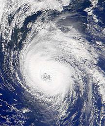
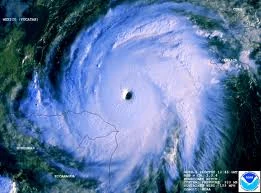
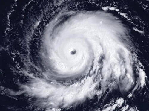
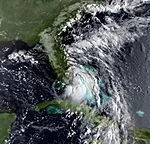
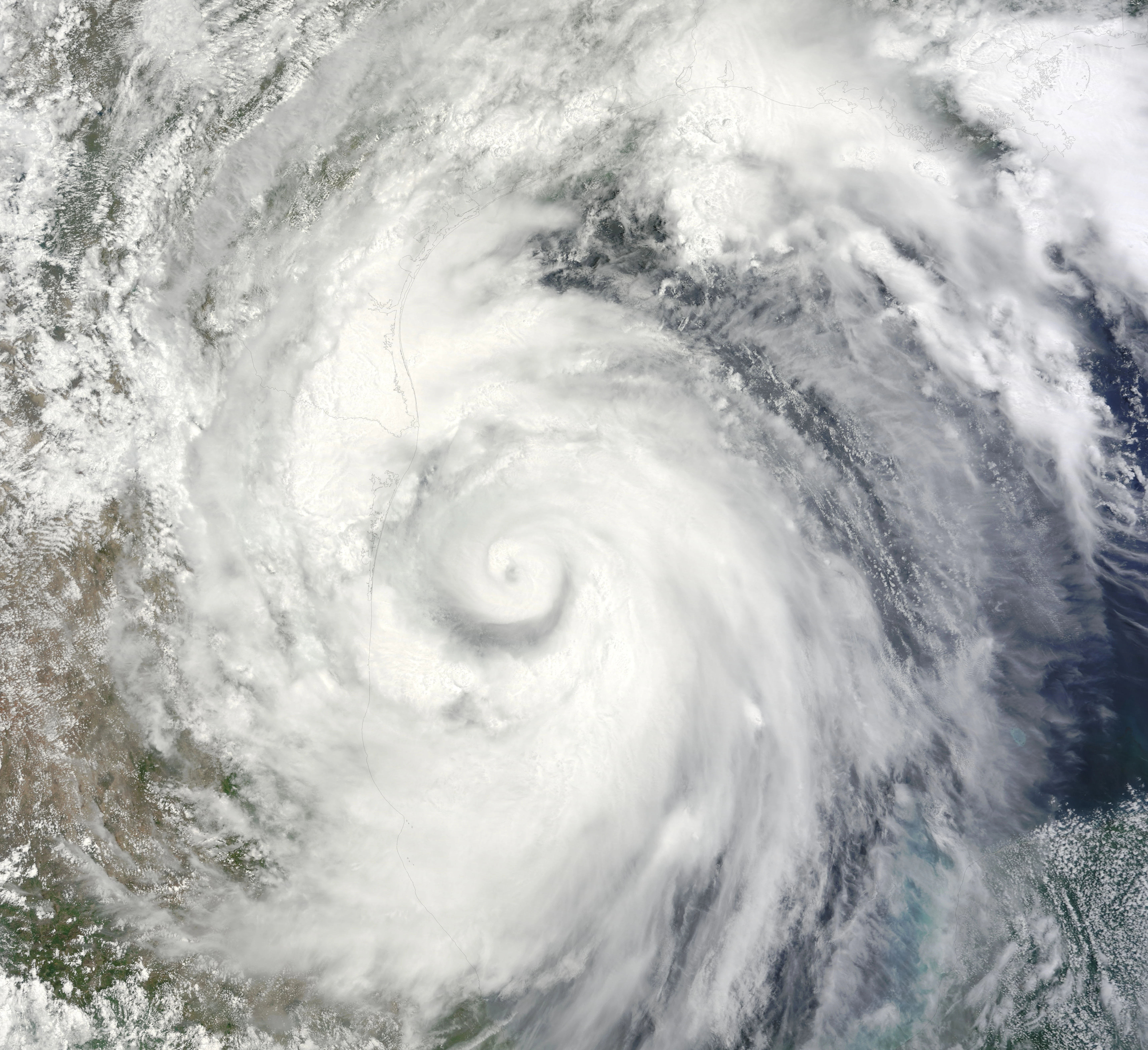
On August 25, the National Hurricane Center began to monitor a tropical wave in the central Atlantic, giving it a low chance of development and saying that slow development was possible. It had a high chance of development early on August 27, and it became Tropical Depression Five later that day. The depression was upgraded to Tropical Storm Erika twelve hours later. Erika was forecast to strengthen under favorable conditions as it approached the Caribbean. On August 30, Erika became a hurricane as it crossed the Windward Islands. Increasingly favorable conditions allowed it to strengthen faster as it moved through the east Caribbean. It became a major hurricane late on August 31. Continuing to strengthen, Erika became a Category 5 the night of September 1, while between Haiti and Colombia. Erika reached its peak intensity of 175 mph and 904 mbar late on September 2, as it brought rain and hurricane-force winds to Honduras. It then turned northward and began to weaken. Early on September 4, it made landfall on the western tip of Cuba as a 155 mph Category 4. Erika moved into the Gulf of Mexico and weakened further due to an eye-wall replacement cycle and increasing wind shear. On September 5, it weakened into a Category 3 as Texas was preparing for the storm (since it was expected to make landfall there). Erika weakened into a Category 2 before making landfall southwest of Galveston, Texas at 2 p.m. on September 6. Erika gradually weakened over the United States, bringing severe thunderstorms and tornadoes along the way, before dissipating early on September 9 while in Missouri. Erika caused a total of $41 billion dollars in damage and 257 deaths throughout its path. The name was later retired and replaced by Erma for the 2021 season.
Tropical Storm Fred[]
| Tropical storm (SSHWS) | |
  | |
| Duration | September 2 – September 4 |
|---|---|
| Peak intensity | 45 mph (75 km/h) (1-min) 998 mbar (hPa) |
A tropical disturbance formed hundreds of miles east of Bermuda on September 1. The NHC gave it a low chance of development at first, but by the next morning, it had rapidly organized and was given a high chance of development. Later that day, it became organized enough to be declared Tropical Depression Six, and it then strengthened into a tropical storm twelve hours later (early on September 3), earning the name Fred. Any strengthening was expected to be slow to occur as it moved slowly northward due to only marginally favorable conditions. Fred reached its peak of 45 mph and 998 mbar on the afternoon of September 3, before it started getting ripped apart by increasing wind shear. It dissipated on the morning of September 4, only 18 hours after peak intensity. Fred didn't cause any damage/deaths because it didn't affect land.
Hurricane Grace[]
| Category 1 hurricane (SSHWS) | |
  | |
| Duration | September 9 – September 14 |
|---|---|
| Peak intensity | 85 mph (140 km/h) (1-min) 984 mbar (hPa) |
An area of disturbed weather formed near the Bahamas on September 7. The National Hurricane Center monitored it for possible development as it moved northwestward. Late on September 8, it had a high chance of development. On September 9, the disturbance became organized enough to be declared Tropical Depression Seven, before it strengthened into Tropical Storm Grace twelve hours after forming. As Grace moved away from the Bahamas and closer to the Carolinas, the NHC predicted it to turn northeast away from land and to gradually strengthen. Early on September 12, Grace strengthened into a hurricane as it turned away from the U.S. It reached its peak intensity of 85 mph and 984 mbar that night north of Bermuda. After that, Grace started weakening, and it weakened into a tropical storm late on September 13. It became extratropical on the 14th hundreds of miles south of Newfoundland. Grace didn't cause any damage/deaths, but it did bring some rain to the Bahamas and Bermuda, and rough surf along the coast of Florida and the Carolinas.
Hurricane Henri[]
| Category 4 hurricane (SSHWS) | |
  | |
| Duration | September 16 – September 27 |
|---|---|
| Peak intensity | 145 mph (230 km/h) (1-min) 936 mbar (hPa) |
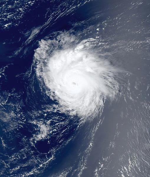
A strong tropical wave moved off the coast of Africa on September 15. At that time, it already had a medium chance of development during the next 48 hours by the NHC. The wave became better organized and had a high chance of development early on the 16th. Later that day, it became organized enough to be declared Tropical Depression Eight near the Cape Verde Islands. Six hours later, the depression strengthened into a tropical storm and was named Henri. Henri moved slowly westward as it strengthened, dumping lots of rain in the Cape Verdes. The NHC predicted gradual strengthening under favorable conditions. Early on September 18th, Henri strengthened into a hurricane as it started to leave the Cape Verdes. Henri picked up its speed and reached its first peak of 80 mph before weakening under increasing wind shear. Late on September 19, it weakened into a tropical storm in the central Atlantic. After that, however, the wind shear weakened, allowing Henri to strengthen again. Early on September 21, Henri restrengthened into a hurricane, and the NHC now had a major in its forecast due to very favorable conditions in its path. Henri strengthened into a Category 2 that night, a Category 3 at 8 a.m. on September 22, and a Category 4 six hours later. It reached its peak of 145 mph and 936 mbar on September 23, and turned northward. Henri started to weaken after that, and became a Category 3 early on September 24 hundreds of miles east of Bermuda. It weakened into a Category 2 that night as it moved northeastward. Late on September 25, Henri weakened into a Category 1, turned eastward, and its forward speed slowed down significantly. Late on September 26, it weakened into a tropical storm as it turned back towards the northeast and its forward speed increased again. Henri became extratropical on September 27 halfway between Newfoundland and the Azores. Henri caused $32 million in damage and 2 deaths, 1 death was in the Cape Verdes and the other death was a surfer that drowned in Bermuda due to the storm's rough surf.
Tropical Storm Ida[]
| Tropical storm (SSHWS) | |
  | |
| Duration | September 30 – October 4 |
|---|---|
| Peak intensity | 50 mph (85 km/h) (1-min) 997 mbar (hPa) |
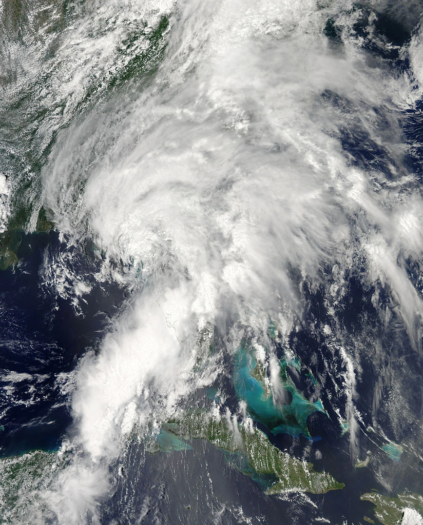
The National Hurricane Center began to monitor an area of disturbed weather east of the Turks & Caicos Islands on September 28. It gradually developed as it moved westward, and early on September 30, it had a high chance of development while entering the Bahamas. It became organized enough to be declared Tropical Depression Nine later that day. Twelve hours later, the depression strengthened into Tropical Storm Ida while in the Bahamas. Ida continued westward, and strengthened to its peak of 50 mph and 997 mbar before making landfall north of Miami, Florida at 11 p.m. on October 1st. On October 2, it weakened into a depression over land and turned northward. Ida later turned northeastward and emerged back into water, allowing it to restrengthen into a tropical storm early on October 3. It turned northward again, and made a second landfall near the South Carolina-North Carolina border at 8 p.m. that day. Ida weakened over land before dissipating on October 4 while entering Virginia. Ida caused $59 million dollars in damage and killed 3 people.
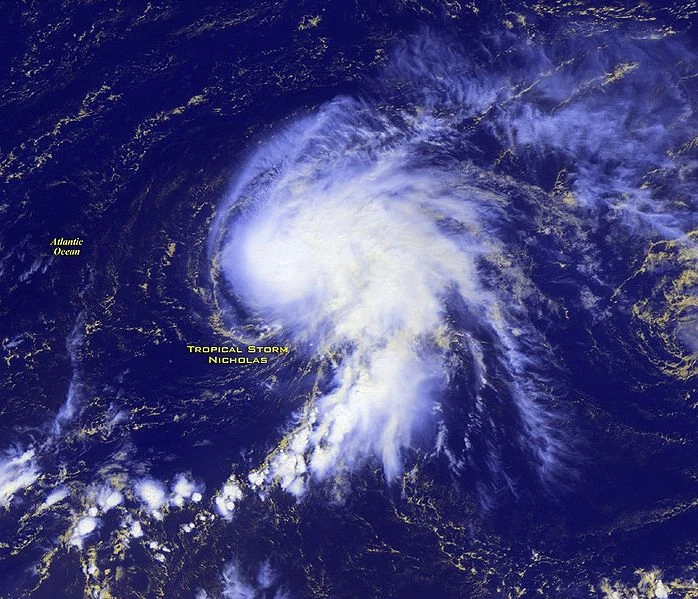
Hurricane Joaquin[]
| Category 2 hurricane (SSHWS) | |
  | |
| Duration | October 6 – October 14 |
|---|---|
| Peak intensity | 100 mph (155 km/h) (1-min) 976 mbar (hPa) |
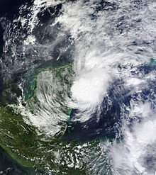
On October 3, a tropical wave moved into the southwestern Caribbean, producing an area of disturbed weather that began to organize. The disturbance had a medium chance of development on October 5, and then a high chance of development early on the 6th. It organized into Tropical Depression Ten later that day, and then into Tropical Storm Joaquin six hours later. Joaquin moved northwest towards Central America, and made landfall near the Nicaragua-Honduras border on October 7. It did not stay over land for long, and it emerged into the northwest Caribbean early on October 8. Joaquin soon encountered favorable conditions which allowed it to strengthen into a hurricane. It reached a first peak of 90 mph before making landfall in the Yucatan Peninsula the evening of October 9. Joaquin weakened into a tropical storm as it crossed the peninsula, and it emerged into the Gulf of Mexico on October 10 with winds of 60 mph. Environmental conditions became very favorable after emerging into the Gulf, and the NHC noted that rapid intensification was not out of the question. Early on October 11, it restrengthened into a hurricane, and it became a Category 2 later that day. However, after strengthening into a Category 2, it stopped strengthening and remained a 100 mph storm for a day as it approached Texas. Late on October 12, it weakened into a Category 1 as it closed in on Texas. Joaquin made landfall in a sparsely-populated region of Texas early on the 13th as an 85 mph hurricane. It started to weaken over land, and eventually dissipated on October 14 while entering Oklahoma. Joaquin caused $565 million dollars in damage and 18 deaths throughout its path.
Tropical Storm Kate[]
| Tropical storm (SSHWS) | |
  | |
| Duration | October 12 – October 14 |
|---|---|
| Peak intensity | 50 mph (85 km/h) (1-min) 996 mbar (hPa) |
An area of disturbed weather formed near Cuba on October 9. The National Hurricane Center gave it a low chance of development at first, saying that some development was possible. The disturbance moved northwest and its chances of formation were upgraded to a medium and then a high chance of development as it got better organized. On October 12, it developed into Tropical Storm Kate in the Gulf of Mexico, skipping depression status. Kate turned northeastward and gradually strengthened as it headed towards Florida. It reached its peak intensity of 50 mph and 996 mbar before making landfall in northwestern Florida late on October 13. Kate quickly weakened over land before the last advisory was issued on the storm at 2 p.m. on the 14th, while entering South Carolina. Kate caused $51 million in damage and killed 2 people.
Tropical Storm Larry[]
| Tropical storm (SSHWS) | |
  | |
| Duration | October 21 – October 26 |
|---|---|
| Peak intensity | 60 mph (95 km/h) (1-min) 995 mbar (hPa) |
On October 19, a tropical wave in the western Caribbean became better organized, and the NHC monitored it for possible development. It had a medium chance of development on October 20 and a high chance that night as it organized. On October 21, Tropical Depression Twelve formed from this wave near Honduras. Six hours later, the depression strengthened into a tropical storm and earned the name Larry. Larry slowly strengthened as it moved westward, and reached its peak intensity of 60 mph and 995 mbar early on October 23 as it got close to landfall in the Yucatan. Later that day, it turned sharply northeast and started to weaken gradually due to moderate wind shear. Larry made a landfall in Cuba on October 24 with 45 mph winds. After emerging into the Florida Straits, it barely strengthened before making landfall on the southern tip of Florida early on October 25. Larry didn't remain over land for long, but strong wind shear began to rip the system apart, weakening it to a depression once it emerged into the Atlantic. The shear settled down a little bit, letting it remain a depression until dissipating on October 26 slightly north of the Bahamas. Its remnants stuck around in the open Atlantic for a week, before getting absorbed into the system that would eventually become Mindy. Larry caused $95 million dollars in damage and 21 deaths throughout its path.
Hurricane Mindy[]
| Category 1 hurricane (SSHWS) | |
  | |
| Duration | November 3 – November 8 |
|---|---|
| Peak intensity | 80 mph (130 km/h) (1-min) 987 mbar (hPa) |
A large area of disturbed weather formed southwest of Bermuda on November 1. The National Hurricane Center monitored it for possible development as it moved slowly northeastward. On November 2, it had a medium chance of development as it absorbed the remnants of Larry. On November 3, it became organized enough to be declared Subtropical Storm Mindy and skipped depression status, due to it having subtropical characteristics. Mindy turned towards the northwest as it gradually strengthened, and it became tropical on the 4th as it struck Bermuda. It continued to slowly strengthen, and soon turned back towards the northeast. Mindy became a hurricane on November 6 and moved to the northeast at a quicker pace. It reached its peak of 80 mph and 987 mbar early on November 7. After that, Mindy started to weaken under cooling SSTs, and it became extratropical on November 8 hundreds of miles south of Newfoundland. Mindy caused minimal damage to Bermuda and no deaths.
Subtropical Depression Fourteen[]
| Subtropical depression (SSHWS) | |
  | |
| Duration | December 5 – December 6 |
|---|---|
| Peak intensity | 35 mph (55 km/h) (1-min) 1002 mbar (hPa) |
On December 4, the National Hurricane Center issued a special tropical weather outlook on an extratropical system north of the Lesser Antilles, giving it a medium chance of becoming subtropical. It became slightly better organized as it moved westward, and on December 5, it was declared Subtropical Depression Fourteen five days after the official end of the season. Significant strengthening was not expected due to wind shear, and it continued westward without strengthening before dissipating on December 6. Subtropical Depression Fourteen didn't cause any damage/deaths because it didn't affect land.
Storm names[]
The following names were used to name tropical cyclones this year. This is the same list used in the 2009 season. The name Joaquin was used in the Atlantic for the first time this year. Joaquin replaced the name of a devastating hurricane that affected Canada in 2003, but was not used in 2009. Unused names are marked in gray.
|
|
|
Retirement[]
Due to extensive damage and deaths, the name Erika was officially retired, and will never be used again to name an Atlantic hurricane. It was replaced by Erma for the 2021 season.
List for 2021:
|
|
|
Season effects[]
This is a table of the storms and their effects in the 2015 Atlantic hurricane season. This table includes the storm's names, duration, peak intensity, Areas affected, damages, and death totals. Damage and deaths include totals while the storm was extratropical, a wave or a low. All of the damage figures are in 2015 USD (the listed damage figure is in millions).
| Storm name |
Dates active | Storm category at peak intensity |
Max 1-min wind mph (km/h) |
Min. press. (mbar) |
Areas affected | Damage (USD) |
Deaths |
|---|---|---|---|---|---|---|---|
| Ana | June 25 – June 30 | Tropical storm | 65 (100) | 993 | Cuba, Yucatan Peninsula, Florida, Southeast U.S. | 306 | 8 |
| Bill | August 7 – August 14 | Category 3 hurricane | 120 (195) | 960 | None | None | 0 |
| Claudette | August 13 – August 15 | Tropical storm | 50 (85) | 996 | Mexico | 43 | 14 |
| Danny | August 18 – August 28 | Category 2 hurricane | 105 (165) | 971 | None | None | 0 |
| Erika | August 27 – September 9 | Category 5 hurricane | 175 (280) | 904 | Windward Islands, Lesser Antilles, Jamaica, Honduras, Cuba, Texas, Louisiana | 41,000 | 257 |
| Fred | September 2 – September 4 | Tropical storm | 45 (75) | 998 | None | None | 0 |
| Grace | September 9 – September 14 | Category 1 hurricane | 85 (140) | 984 | The Bahamas, Bermuda | None | 0 |
| Henri | September 16 – September 27 | Category 4 hurricane | 145 (230) | 936 | Cape Verde | 32 | 2 |
| Ida | September 30 – October 4 | Tropical storm | 50 (85) | 997 | The Bahamas, Florida, Southeast U.S., The Carolinas | 59 | 3 |
| Joaquin | October 6 – October 14 | Category 2 hurricane | 100 (155) | 976 | Nicaragua, Honduras, Belize, Yucatan Peninsula, Texas | 565 | 18 |
| Kate | October 12 – October 14 | Tropical storm | 50 (85) | 996 | Florida, Southeast U.S. | 51 | 2 |
| Larry | October 21 – October 26 | Tropical storm | 60 (95) | 995 | Honduras, Belize, Yucatan Peninsula, Cuba, Florida, The Bahamas | 95 | 21 |
| Mindy | November 3 – November 8 | Category 1 hurricane | 80 (130) | 987 | Bermuda | Minimal | 0 |
| Fourteen | December 5 – December 6 | Tropical depression | 35 (55) | 1002 | None | None | 0 |