| Category 4 major hurricane (SSHWS/NWS) | |
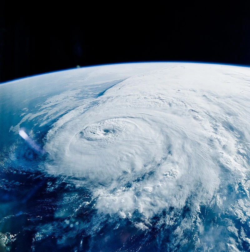 Elizabeth rapidly strengthening on September 14, shot from a NASA space shuttle. | |
| Formed | September 5, 2037 |
|---|---|
| Dissipated | September 19, 2037 |
| (Extratropical after September 17) | |
| Highest winds | 1-minute sustained: 130 mph (215 km/h) |
| Lowest pressure | 948 mbar (hPa); 27.99 inHg |
| Fatalities | 1,562 |
| Damage | $41.23 billion (2037 USD) |
| Areas affected | Leeward Islands, Trinidad & Tobago, Venezuela, Haiti, Dominican Republic, Cuba, Bahamas, United States |
| Part of the 2037 Atlantic Hurricane Season | |
Hurricane Elizabeth was an extremely devastating and deadly hurricane that ravaged parts of the Caribbean and United States in September 2037. Originating from an African wave, Elizabeth formed near Trinidad on September 5. It moved through the Caribbean before getting caught in unusual steering currents near Florida, before continuing into the Gulf of Mexico and reaching peak intensity as it made landfall in Mississippi. It was the strongest hurricane to make landfall in Mississippi pressure-wise since Hurricane Katrina, and the strongest in wind speed since Hurricane Camille.
The impacts of Elizabeth were widespread and very severe. Parts of Florida were inundated by water as Elizabeth made its two landfalls, Haiti suffered from extreme rainfall as over 1,000 people died, and Mississippi's gulf coast did not recover for several years. It was the first hurricane to make two landfalls in Florida at hurricane intensity since Hurricane Irma.
Meteorological History[]

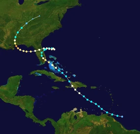
Map plotting the storm's track and intensity, according to the Saffir–Simpson scale
Tropical storm (39–54 mph, 63–87 km/h)
Category 1 (74–95 mph, 119–153 km/h)
Category 2 (96–110 mph, 154–177 km/h)
Category 3 (111–129 mph, 178–208 km/h)
Category 4 (130–156 mph, 209–251 km/h)
Category 5 (≥157 mph, ≥252 km/h)

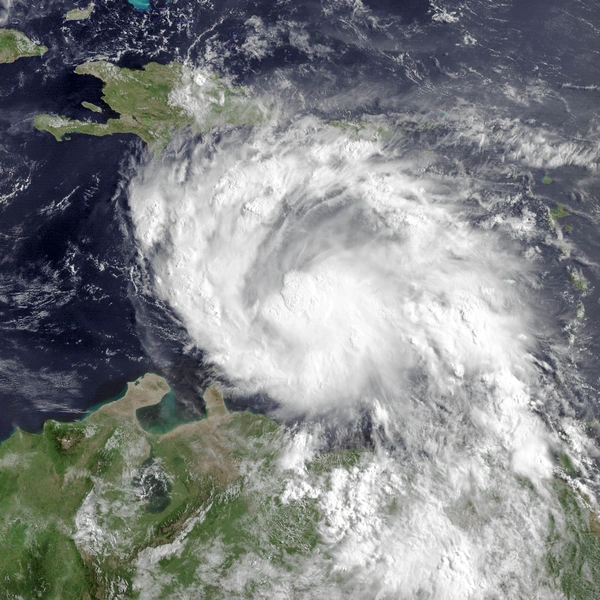
Tropical Storm Elizabeth strengthening on September 6.
A large tropical wave developed over Senegal in late August 2037. It moved off the coast of Africa on August 30, displaying waning convection. Due to poor conditions, the wave did not develop as it traversed the Tropical Atlantic, however, the NHC noted it had potential to develop further west, where conditions were expected to be more conducive. The wave was unusually far south for the time of year, displaying a latitude normally seen in the s
ummer. As the wave approached the Leeward Islands, the air moistened up and shear began to relax, and the wave began to show signs of organization. Continued organization occurred until September 5, when NHC deemed it sufficiently organized to be declared as Tropical Depression Five. The well-organized system quickly developed a Central Dense Overcast and intensified into Tropical Storm Elizabeth six hours later.
With low shear and warm waters ahead, conditions were prime for intensification. Elizabeth made its first landfalls on Trinidad & Tobago with winds of 50 mph, before emerging into the Caribbean sea. Despite favorable conditions, Elizabeth only gradually intensified due to drier air. The storm began to draw closer to Haiti, and it soon became clear an eye was forming. On September 7, supported by recon, Elizabeth was upgraded to a hurricane. Elizabeth continued to intensify to an initial peak of 85 mph before making landfall on Belle Anse, Haiti at that intensity. The storm continued over the country, briefly emerging back over water before making a second Haitian landfall in Anse-Rouge, with winds of 75 mph. This landfall caused Elizabeth to weaken back to a tropical storm, as it appeared less defined on satellite. But it began to re-intensify as it emerged off the coast, and was re-upgraded to a hurricane on September 9.
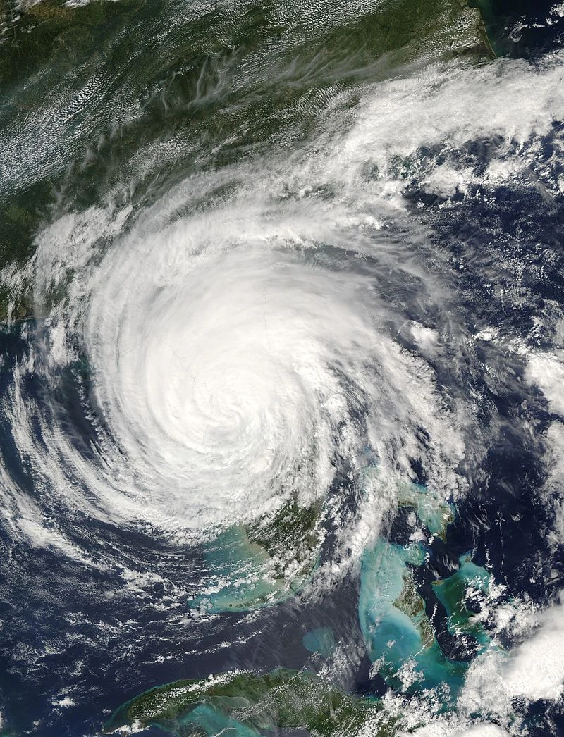
Hurricane Elizabeth over Florida.
In the Bahamas, Elizabeth was able to intensify quickly and was upgraded to a Category 2 hurricane on September 10, and reached what was initially thought to be its peak, winds winds of 110 mph before making landfall in Boynton Beach, Florida, at that intensity. The storm weakened over Florida, but it emerged off the coast the next day, and was expected to continue out to sea. However, a ridge began to form, trapping the storm. The NHC stated that the storm would not move much until the trough to the west moved north in about 18 hours. Because of this, it was expected to track similar to Ophelia of 2005, weaving off the east coast. Elizabeth re-intensified into a hurricane for the third time on September 11. But instead of weaving off the east coast, the storm instead began to charge westward, making landfall in Daytona Beach, Florida, with 90 mph winds. Unlike the first time, Elizabeth retained hurricane intensity as it crossed the state, and emerged into the Gulf of Mexico with 85 mph winds.
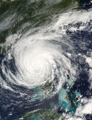
Elizabeth's eye cleared quickly as it moved west, intensifying quicker than before. The National Hurricane Center anticipated a landfall in Louisiana as a Category 2 hurricane. Instead, Elizabeth further intensified into the first major hurricane of the season on September 14, marked by a very clear, symmetric eye and overall structure. Elizabeth attained its ultimate peak that night, as a weak Category 4 hurricane with 130 mph winds. And at this very intensity, Elizabeth struck near Gulfport, Mississippi. Soon after landfall, Elizabeth attached itself to a front passing over the United States, and the storm was deemed post-tropical on September 17.
Preparations[]
For Trinidad & Tobago, the first tropical storm warning was issued on September 4, when Elizabeth was a potential tropical cyclone. The residents prepared for the storm quickly, preparing sandbags and boarding up doors. The last tropical storm watch was lifted on September 6.
Haiti received a tropical storm watch, which was later upgraded to a warning on September 7. This was later changed to a hurricane warning when Elizabeth grew stronger. The last watches were lifted on September 9.
Impact[]
Haiti[]
Due to Elizabeth's high rainfall, many mudslides were reported, killing at least 1,300 people. Beaches along the coast were eroded due to the high winds and storm surge, the latter of which flooded several towns on the southern coast.
Several dozen shelters opened across the country, taking in roughly 1.5 million people combined. However, some coastal shelters were flooded by the hurricane as it passed through. A video went viral when a woman clung to a swaying telephone pole in the hurricane's Category 1 winds.
Bahamas[]
Several Bahamian islands were closed prior to the storm's passage, as it was expected to be a strong tropical storm as it passed through. Cruise ports were closed all across the Bahamas, including Grand Turk. The Island of Nassau sustained particularly heavy damage as Elizabeth moved directly over it as a intensifying hurricane. The port did not re-open until November. Overall damage was somewhat low.
Florida[]
The hurricane's stalling brought this state several days of rain, which some saw as a relief due to the U.S drought of Summer 2037, but accumulations proved high enough to cause major flooding and flood several cities. This included Miami, which was only just south of where Elizabeth struck at Category 2 strength. The storm's direct hit on Daytona Beach was almost unprecedented, and left the popular resort "with much repair to be done".
Mississippi[]
The gulf coast of Mississippi was completely displaced by Elizabeth's intense landfall. Storm surge capped at 12 feet, flooding streets in Biloxi and Gulfport, as well as other places. The unexpected rapid intensification prior to landfall left many people unprepared for a Category 4 storm, as they had only prepared for a Category 2 storm. During the storm, a crane collapsed into a building that was intended to completely redefine the port city of Gulfport, and this delayed the project by many years. The governer declared Mississippi a "disaster area", and several groups were deployed to help those who were stranded.
Aftermath[]
Retirement[]
Due to the catastrophic impacts across the Caribbean and United States, as well as the deaths of over 1,000 people, the name Elizabeth was officially retired at the WMO conference in April 2038. The name Esther was chosen to replace it for use in 2043.