The 2023–24 South-West Indian Ocean tropical cyclone season was a near-average South-West Indian Ocean tropical cyclone season. The majority of the tropical cyclones forming within this basin are monitored by the Regional Specialized Meteorological Center (RSMC) headquartered in Réunion, an overseas department of France.
The season's first storm, Moderate Tropical Storm Amelie, developed on November 29. Several days later, Moderate Tropical Storm Bora developed, as well as Moderate Tropical Storm Clove a further two weeks later. Throughout January 2024, two more tropical cyclones, Severe Tropical Storms Dacara and Elsa, formed. Next, two storms, Tropical Cyclone Fanta and Moderate Tropical Storm Glimmer, formed in February, followed by an additional two storms, Severe Tropical Storm Hazelle and Moderate Tropical Storm Ilene, developing in March. Finally, in April, Tropical Cyclone Jile formed, becoming the season's strongest cyclone. Although a number of storms, five, became severe tropical storms, only two, Fanta and Jile, intensified further into tropical cyclones.
Four tropical cyclones (Amelie, Bora, Elsa, and Jile) affected land during the 2023–24 South-Western Indian Ocean cyclone season, two (Amelie and Bora) of which made landfall, both over Madagascar. Amelie, Bora, and Jile all tapped Madagascar with slight precipitation; on the contrary, mass flooding in Réunion was reported from Elsa. Collectively, the storms of the 2023–24 South-West Indian Ocean cyclone season caused nine fatalities and $900,000 (2024 USD) in losses.
Season summary[]
For the entirety of the 2023–24 South-West Indian Ocean cyclone season, the Météo-France's (MFR) meteorological department in Réunion issued advisories on all tropical cyclones that formed in the Indian Ocean south of the Equator and between 90º E and the coastline of the African mainland. To assess a cyclone's intensity, the MFR used the Dvorak technique. Also, the Joint Typhoon Warning Center (JTWC), a joint United States Navy – United States Air Force task force, issued advisories for all of the season's tropical cyclones alongside the MFR. [1] Overall, both agencies tracked ten named storms, slightly above the long-term average of nine. [2]
Storms[]
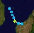
Moderate Tropical Storm Amelie[]

Track map of Moderate Tropical Storm Amelie
Early on November 27, the JTWC reported the development of a tropical wave 300 miles east of Madagascar. Within a couple days, MFR issued its first advisory on the system at 1200 UTC on November 29, designating it Tropical Depression 01S; six hours later, the JTWC began issuing advisories as well. Continuing gradual intensification, the depression moved westward toward Madagascar, gaining deep convection. Eventually, on November 30, the MFR declared the depression a moderate tropical storm and named it Amelie, with the JTWC also upgrading the depression to a tropical storm. As Amelie continued traveling westward, MFR assessed the storm as having reached its peak intensity of 45 miles per hour (mph) (70 kilometres per hour (km/h) winds (10-minute sustained winds) and a minimum barometric pressure of 993 millibars (mbar) (hectopascals (hPa); 29.32 inches of mercury (inHg)) at 0600 UTC December 1. The JTWC assessed Amelie's peak winds to also be 45 mph (70 km/h) (10-minute sustained) and a barometric pressure of 993 mbar (hPa; 29.32 inHg). Amelie began to weaken thereafter, as wind shear destroyed most of its convection. By 0000 UTC December 2, the JTWC downgraded the storm back to a tropical depression, as it appeared very disorganized on satellite imagery. Shortly afterwards, Amelie made landfall in the Sava Region of Madagascar. The MFR maintained Amelie as a moderate tropical storm until 0600 UTC December 2, when it dissipated over the mountains of central Madagascar; the JTWC also ceased advisories at that time.
Floods from Amelie in Sambava drowned four citizens and caused $400,000 (2024 USD) in damage and losses, mainly in the fishing industry.
Moderate Tropical Storm Bora[]
Track map of Moderate Tropical Storm Bora
On December 5, MFR classified a tropical depression located just to the east of Mozambique, numbering it 02S. Moving southeastward, the JTWC initiated advisories twelve hours after the MFR, also classifying the system as a tropical depression. At 0600 UTC December 6, both MFR and the JTWC classified the depression as a 40 mph (65 km/h), 995 mbar (hPa; 29.38 inHg) tropical storm for six hours, with the former agency naming the system Bora. Bora grazed the Madagascar coast, rapidly weakening to a tropical depression and making a landfall over the nation's Boeny Region at 1500 UTC December 6. The system dissipated within three hours of landfall.
Gusty winds from Bora caused three fatalities around Mahajanga; two of the deaths were from drowning, another from electrocution. Gusts of up to 105 mph (170 km/h) damaged various structures in Mahajanga, causing damage reports of approximately $300,000 (2024 USD).
Moderate Tropical Storm Clove[]

Track map of Moderate Tropical Storm Clove
On the afternoon of January 3, at 1200 UTC, MFR reported the development of a tropical disturbance, numbered 03S, well to the northeast of Madagascar. Within six hours, both the JTWC and MFR declared the disturbance a tropical depression. Convection deepened around the system, setting the stage for rapid intensification. On January 4, less than a day after being first numbered, the MFR upgraded the depression to a moderate tropical storm, with the RSMC naming it Clove; the JTWC followed suit six hours later. Afterwards, Clove gradually intensified while moving southwards, being dragged by a trough. At 0600 UTC January 7, the storm reached its peak intensity, consisting of 50 mph (80 km/h) winds (10-minute sustained) and a 991 mbar (hPa; 29.26 inHg) pressure reading, as assessed by the MFR. The JTWC reported slightly lower winds, 45 mph (70 km/h) (1-minute sustained), but the same barometric pressure. Clove continued moving southward, gradually losing its convection and organization. Late on January 8, Clove turned southeast into a region of cool sea surface temperatures (sea surface temperatures), stripping the system of all convection. The MFR and JTWC both downgraded the storm to a depression at 0000 UTC January 8, before it dissipated altogether six hours later.
Clove did not cause any known impact on land. However, two cruise ships had to divert their paths because of the storm's fierce rain.
Severe Tropical Storm Dacara[]

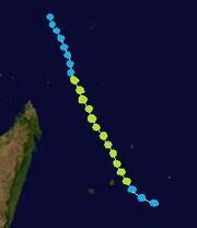
Track map of Severe Tropical Storm Dacara
A tropical wave was reported by MFR on January 16 off the coast of Mozambique. It moved east for a couple of days, developing a closed circulation, a vital factor in tropical cyclone development. On January 17, at 1800 UTC, MFR began issuing bulletins on the wave, upgrading it to Tropical Disturbance 04S. Warm sea surface temperatures quickly intensified the disturbance to a depression in twelve hours. However, heavy wind shear halted the depression's development for two days. During this time, the JTWC initiated advisories at 0600 UTC January 19, and a trough dragged the system southeastward. By 0000 UTC January 21, convection significantly deepened, and MFR upgraded the system to Moderate Tropical Storm Dacara, with the JTWC reporting the system became a tropical storm six hours later. Over the next two days, Dacara entered a region of warm sea surface temperatures, increasing its convection. Noting organization improvement on satellite imagery, MFR upgraded the storm to a severe tropical storm at 0000 UTC on January 23. Six hours later, the JTWC assessed Dacara as having reached its peak intensity, attaining 1-minute maximum sustained winds of 70 mph (115 km/h) and a minimum barometric pressure of 990 mbar (hPa; 29.23 inHg). Dacara maintained its peak intensity until 0600 UTC January 24; around that time, MFR reported the system's peak intensity, attaining 10-minute maximum sustained winds of 60 mph (95 km/h); MFR's barometric pressure for Dacara was equivalent to the JTWC's. Immediately after MFR reported the storm's peak, Dacara weakened to a tropical depression, according to the JTWC. However, despite the abrupt decrease of convection, MFR maintained the system as a tropical depression until its dissipation at 1800 UTC on January 24.
No known impact was reported from Severe Tropical Storm Dacara.
Severe Tropical Storm Elsa[]
Track map of Severe Tropical Storm Elsa
A low pressure system developed on February 8 well north of Madagascar. MFR begun issuing bulletins on the disturbance at 0600 UTC on February 10 500 miles north of Cap D'Ambre, Madagascar, upgrading it to Tropical Depression 05S. The JTWC initiated advisories at 0600 UTC February 11 as the depression moved south-southeastward. Following a slight increase in convection, the MFR upgraded Tropical Depression 05S to Moderate Tropical Storm Elsa at 1800 UTC that same day. However, the JTWC did not upgrade the system to a tropical storm until 1800 UTC the following day because of a lack of deep convection. Continuing south-southeastward, Elsa further intensified, absorbing very warm sea surface temperatures east of Madagascar. At 0000 UTC on February 14, MFR upgraded Elsa to a severe tropical storm. Twelve hours later, the agency assessed the system as having reached its peak intensity, attaining 10-minute maximum sustained winds of 65 mph (105 km/h) and a minimum barometric pressure of 988 mbar (hPa; 29.18 inHg). The JTWC estimated Elsa to have reached its peak intensity of 55 mph (90 km/h) at 0000 UTC on February 15. Throughout February 15, Elsa gradually weakened as wind shear picked up, with MFR downgrading the system to a moderate tropical storm at 1200 UTC. By 0600 UTC on February 16, the JTWC demoted Elsa to a tropical depression. Around this time, the storm began executing a cyclonic loop due to its proximity to an incoming trough. The MFR also downgraded Elsa to a tropical depression at 1800 UTC. Six hours later, as the system completed its small loop, it dissipated southeast of Réunion.
Heavy rainfall from Severe Tropical Storm Elsa was reported in Réunion. The maximum precipitation recorded was 43 inches (in) (169 millimetres (mm)) in Saint-Denis. Across Réunion, numerous floods swept a man out to sea, displaced hundreds of residents, and caused $100,000 (2024 USD) in losses.
Tropical Cyclone Fanta[]


Track map of Tropical Cyclone Fanta
A tropical wave formed over the open waters of the Indian Ocean. Moving west-southwards, it gradually intensified under warm SST conditions. On February 22, two days after being first tracked, the JTWC and MFR simultaneously upgraded the wave to a tropical depression at 0600 UTC, with the latter agency numbering it 06S. Over the next day, the depression gradually strengthened, developing deep convection. Eventually, at 1200 UTC on February 23, the depression produced winds of 40 mph (65 km/h), prompting MFR and the JTWC to upgrade it to a moderate tropical storm. Upon its upgrade, it was named Fanta by MFR. Rapid intensification enused, and MFR reclassified Fanta as a severe tropical storm just six hours after becoming a moderate tropical storm. An eye feature rapidly developed on satellite imagery, and Dvorak technique estimates suggested a hurricane-strength system. Based on this data, MFR upgraded Fanta to a tropical cyclone at 1200 UTC on February 24, the first of the season. Similarly, the JTWC reclassified Fanta as a Category 1 tropical cyclone. Hours later, the cyclone reached its peak intensity, consisting of 80 mph (130 km/h) winds (10-minute sustained) and a 974 mbar (hPa; 28.76 inHg) pressure reading, as assessed by MFR. The JTWC reported peak winds of 75 mph (120 km/h) (1-minute sustained). After Fanta reached its maximum intensity, it began to lose strength very quickly. Fanta weakened back to a severe tropical storm at 0000 UTC on February 25. The JTWC also downgraded the system to a tropical storm at that time. Over the next 24 hours, Fanta lost most of its convection, which had given it a defined apperance on satellite imagery, primarily because of heavy wind shear attacking the storm. It was downgraded to a tropical depression on February 26 by both MFR and the JTWC, having lost almost all of its convection. Fanta continued degenerating throughout February 26 until it dissipated at 1200 UTC that day, devoid of any organization.
No known land impact was reported from Tropical Cyclone Fanta.
Moderate Tropical Storm Glimmer[]


Track map of Moderate Tropical Storm Glimmer
On March 2, a tropical wave exited the coast of Madagascar. After moving northeastwards for two days, MFR classified the system as Tropical Depression 07S. On that same day, the JTWC also classified the disturbance as a tropical depression. As the depression moved north-northwestwards, it entered a region of cool sea surface temperatures, preventing significant development. A trough picked up the system on March 5, dragging it in an easterly direction. Entering a region of warm sea surface temperatures, the depression began developing significant convection. Based on satellite imagery data, MFR upgraded Tropical Depression 07S to a moderate tropical storm, naming it Glimmer; the JTWC followed suit, upgrading the depression to a tropical storm the next day. After its naming, Glimmer gradually intensified, reaching its peak intensity on March 7 according to MFR, consisting of a 10-minute sustained wind reading of 45 mph (70 km/h) and a minimum barometric pressure of 991 mbar (hPa; 29.26 inHg); the JTWC reported the same peak intensity. Glimmer maintained its intensity for another day, before MFR and the JTWC both downgraded the storm to a tropical depression. In addition, the trough which had dragged Glimmer eastward for the previous two days moved away from the system, causing it to move southwards. As the system lost all organization, based on satellite imagery, the JTWC declared Glimmer extratropical on March 9, with MFR following suit two days later. Glimmer's remnants persisted for another two days, while still moving southwards, before being absorbed into a much stronger extratropical cyclone.
No impact of any kind was reported from Moderate Tropical Storm Glimmer.
Severe Tropical Storm Hazelle[]

Track map of Severe Tropical Storm Hazelle
According to MFR, a tropical depression, numbered 08S, formed on March 11 at 0600 UTC from a thunderstorm burst originating from the Intertropical Convergence Zone (ITCZ). It rapidly intensified, absorbing warm sea surface temperatures and developing extremely deep convection. Twelve hours later, MFR upgraded the depression to Moderate Tropical Storm Hazelle. The JTWC initiated advisories on the system at 0600 UTC on March 12, upgrading it to a tropical storm twelve hours later. Moving southwards for the entirety of its duration, Hazelle gradually intensified under warm sea surface temperatures. An eye feature began to develop on satellite imagery on March 14, but neither MFR nor the JTWC upgraded Hazelle to tropical cyclone intensity at that time. Moreover, the eye feature remained clearly defined for the next four days. On March 15, at 1200 UTC, MFR upgraded Hazelle to a severe tropical storm, noting sufficient organization in the system. By March 17, Dvorak technique estimates indicated Hazelle had intensified into a hurricane-force system; however, neither the JTWC nor MFR upgraded the system, despite an clearly defined eye and a symmetrical organization on satellite imagery. Moreover, on 1200 UTC that same day, MFR determined that Hazelle had reached its peak intensity, attaining 10-minute maximum sustained winds of 70 mph (115 km/h) and a minimum barometric pressure of 978 mbar (hPa; 28.88 inHg). In addition, the JTWC assessed Hazelle to have attained 1-minute maximum sustained winds of 65 mph (105 km/h). After reaching its peak intensity, Hazelle began gradually weakening, losing its convection and organization. At 1800 UTC on March 19, MFR demoted the severe tropical storm to a moderate tropical storm. Following another round of significant weakening, the JTWC declared Hazelle extratropical at 1800 UTC on March 21, as it had lost all of its convection and most of its organization. However, MFR continued issuing bulletins on Hazelle for another three days, when the agency, along with the JTWC, declared the system dissipated.
On Rodrigues, rainfall amounting up to 4.53 in (17.83 mm) from Hazelle was recorded in Port Mathurin. However, no fatalities or damage was reported from the storm, and no known impact occured elsewhere.
Moderate Tropical Storm Ilene[]


Track map of Moderate Tropical Storm Ilene
An extremely well-defined area of thunderstorm activity formed in early April. It developed very rapidly, and at 1800 UTC on April 4, MFR upgraded the disturbance to Tropical Depression 09S, after discovering a closed circulation. The JTWC began issuing advisories on the system six hours later. The depression quickly developed deep convection in all four of its quadrants, and at 0600 UTC on March 5, a buoy in the Indian Ocean recorded winds of 41 mph (65 km/h). Based on this data, the JTWC and MFR simultaneously upgraded Tropical Depression 09S to a moderate tropical storm, with the latter agency naming it Ilene. Shortly after the system's naming, a trough caused it to drift south-southwestwards. A lack of very warm sea surface temperatures disrupted Ilene's intensification process, and it did not significantly gain any strength, nor did it develop symmetrical organization. At 1800 UTC on March 6, Ilene reached its peak intensity according to MFR, attaining winds of 40 mph (65 km/h) (10-minute sustained) and a minimum barometric pressure of 996 mbar (hPa; 29.41 inHg); the JTWC's determined peak for the storm did not differ than that of MFR's. After peaking in intensity, heavy wind shear, along with cool sea surface temperatures, significantly disrupted Ilene, stripping away almost all of its convection and organization. The JTWC downgraded the storm to a tropical depression at 0600 UTC on March 7, with MFR following suit 12 hours later. Around this time, the trough which had carried Ilene south-southwestwards abruptly dissipated, leaving the system to briefly move west-southwards before both MFR and the JTWC declared Ilene dissipated at 0600 UTC March 8; both agencies noted the loss of a closed circulation as well.
No land impact was reported from Moderate Tropical Storm Ilene.
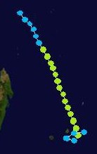
Tropical Cyclone Jile[]


Track map of Tropical Cyclone Jile
On April 15, MFR began to track a low pressure system located far from any landmasses. The JTWC also began to monitor the disturbance that same day. Initially, the system was very disorganized, but it began to show signs of sufficient organization and evidence of a closed circulation within a few days. By April 17, a closed circulation and deep convection were both apparent in the disturbance, as noted on satellite imagery. Consequently, MFR upgraded the system to a moderate tropical storm at 1200 UTC that day, numbering it 10S and naming it Jile, having skipped tropical disturbance and depression status. In addition, the JTWC also upgraded the disturbance straight to a tropical storm six hours later. After its naming, Jile gradually tracked west-southwestward, slowly strengthening admist the warm sea surface temperatures in the region. During this time, the storm's organization improved, becoming more symmetrical, and an eye feature developed on satellite imagery. By 0600 UTC on April 19, MFR reclassified Jile as a severe tropical storm. Entering a region containing high, moist humidity, the storm began to accelerate its intensification pace; thick clouds and strong thunderstorms developed near its center, particuarly in the eyewall. Ultimately, a buoy near Jile's center recorded a windspeed of 75 mph (120 km/h). As a result, at 0600 UTC on April 20, MFR upgraded the storm to tropical cyclone intensity, with the JTWC following suit, upgrading it to a Category 1 tropical cyclone. Over the next few days, wind shear slightly increased around Jile, causing its intensification to slow down, but the wind shear did not stop the cyclone from intensifying altogether. Moreover, at 1800 UTC on April 21, MFR assessed Jile as having reached its peak intensity, consisting of 80 mph (130 km/h) winds (10-minute sustained) and a barometric pressure reading of 965 mbar (hPa; 28.50 inHg); the storm's pressure made it the strongest storm of the 2023–24 South-West Indian Ocean cyclone season. However, the JTWC assessed Jile's peak winds to be 75 mph (120 km/h) (1-minute sustained). After reaching its maximum intensity, Jile switched direction, now moving west-northwestward toward northern Madagascar. It maintained peak intensity throughout 0000 UTC on April 23, when MFR downgraded it to a severe tropical storm; six hours later, the JTWC demoted the cyclone back to a tropical storm. Afterwards, Jile began rapidly weakening, losing its eye feature, convection, thunderstorm activity, and organization. Only 12 hours after losing tropical cyclone intensity, MFR further downgraded the system to a moderate tropical storm, and by 0000 UTC on April 24, only six hours after that, both the JTWC and MFR declared Jile had dissipated. It was located just to the east of the northeastern Madagascar coastline.
Tropical Cyclone Jile produced significant amounts of precipitation which fell on Réunion. Many weather stations across the island recorded over three inches of rain, with the maximum total being 9.04 in (35.59 mm), which was recorded in Saint-Joseph. Hundreds of landslides were reported across the island, burying small communities and rural vegetation as well as displacing approximately 5,000 residents from their homes. One man was buried in the landslide, killing him instantly. Dozens more were injured from the landslides and torrential rainfall; they had to be treated at local hospitals. Overall, the damage on Réunion from Jile is estimated to be around $100,000 (2024 USD). Elsewhere, gusty winds of up to 64 mph (103 km/h) were recorded in Madagascar, but no impact was reported on the island.
See also[]
References[]
- ↑ Joint Typhoon Warning Center Mission Statement. Joint Typhoon Warning Center (2011). Archived from the original on May 3, 2013. Retrieved on June 28, 2013.
- ↑ Cyclone Season 2001–2002. RSMC La Reunion. Meteo-France. Retrieved on June 28, 2013.