The 2013 Atlantic hurricane season was an active Atlantic hurricane season that produced 17 tropical cyclones, 16 tropical storms, eight hurricanes, and four major hurricanes. It officially started on June 1 and ended on November 30, dates which conventionally delimit the period during which most tropical cyclones form in the Atlantic Ocean.With sixteen storms, the season was tied for the sixth most active Atlantic hurricane season on record. The strongest hurricane of the season was Hurricane Fernand, which reached Category 5 status on the Saffir-Simpson Hurricane Scale north of Hispanola; Fernand later struck Florida as a Category 4 hurricane, causing $29.5 billion in damage (2013 USD) and a total of 102 deaths across the Mid-Atlantic region of the United States.
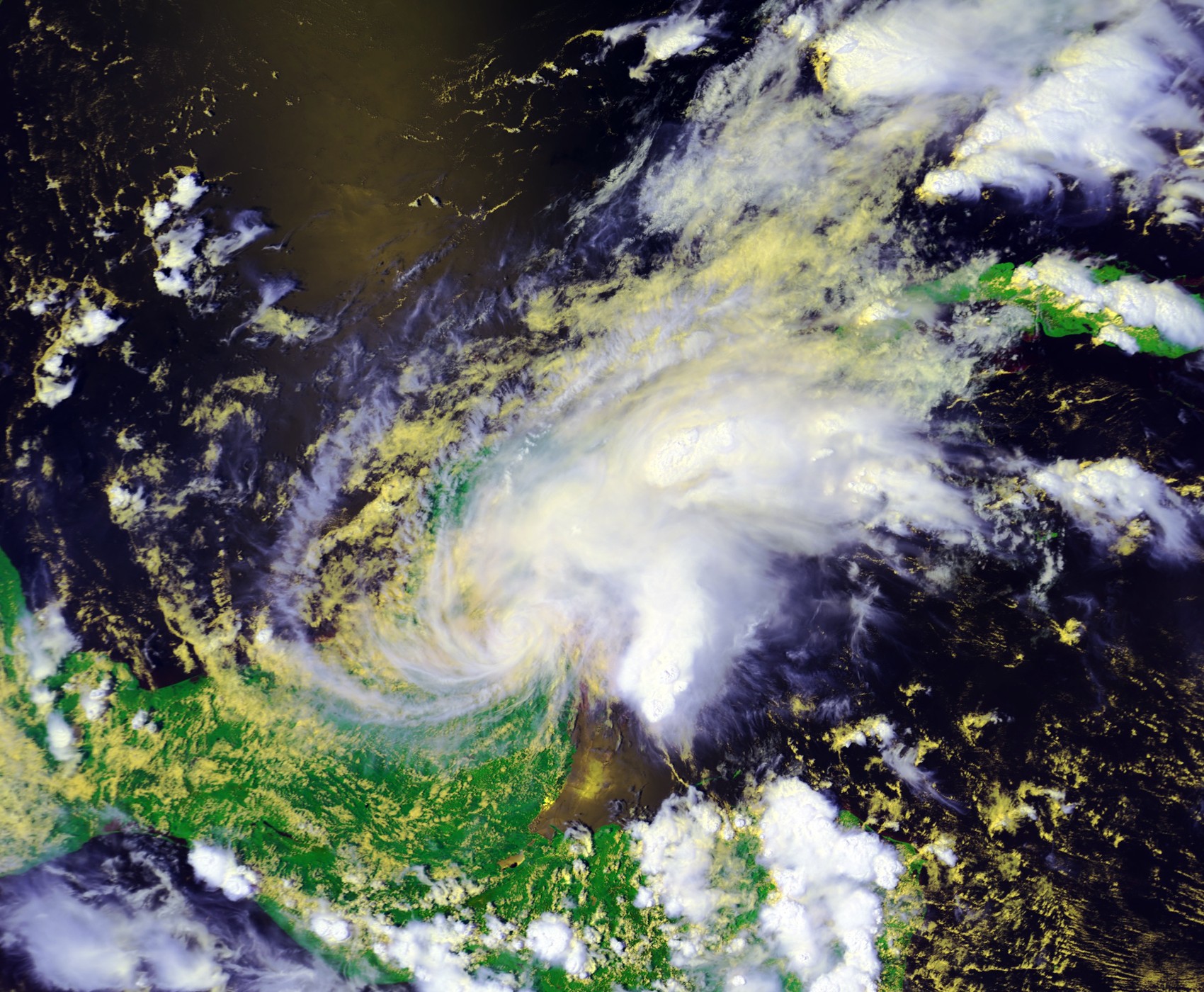
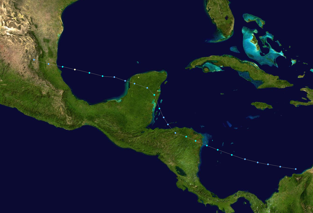
The season began with Hurricane Andrea on Jun 15. In early September, Tropical Storm Erin caused torrential flooding in Hispanola, on the island it caused over 2,000 deaths and $610 million in damage (2013 USD). Hurricane Lorenzo caused considerable destruction to Mexico, particularly Cozumel, as a Category 4 hurricane, shutting down much of the tourist economy for as long as 4 months.
Seasonal Forecasts[]
Season Activity[]

The 2013 Atlantic hurricane season totaled to 16 named storms, which was above the 1950-2012 Atlantic basin average. This was due to the strong La Nina that had persisted since February of that year. While June through August saw generally average activity, September of 2013 was tied for the most number of storms for that month, with 7. However, October and November were average. One storm, Pablo, formed outside the bounds of the conventional hurricane season - towards the end of December.
Storms[]
Hurricane Andrea[]
- Main article: Hurricane Andrea (2013)
| Category 1 hurricane (SSHWS) | |
  | |
| Duration | June 15 – June 20 |
|---|---|
| Peak intensity | 80 mph (130 km/h) (1-min) 981 mbar (hPa) |
On June 12, a vigorous tropical wave moved off the coast of Venezuela, and the with favorable conditions the system organized into a tropical depression on June 15 about 70 miles east of San Miguel, Mexico. Under the influence of a trough, the storm slowly drifted to the north and northeast and strengthened into a tropical storm on June 16. The next day, Andrea intensified into a hurricane, reaching peak intensity with winds of 80 mph before making landfall on Apalachicola, Florida on June 19, where the storm weakened to a depression and dissipated early the next morning.
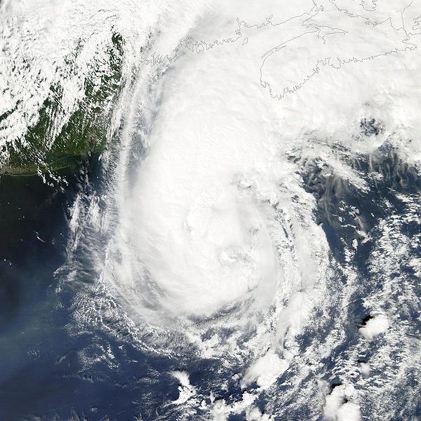
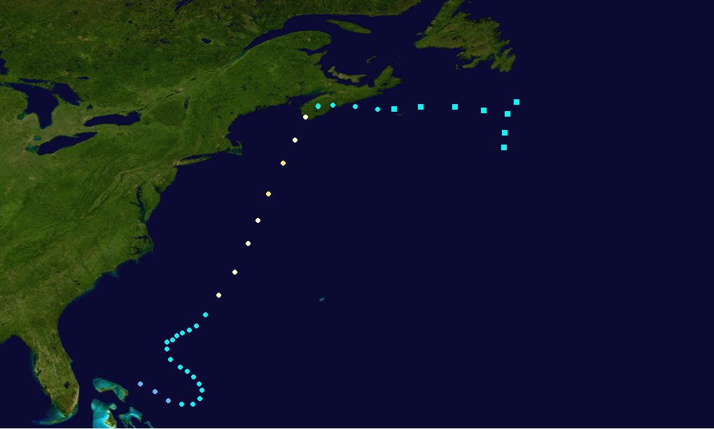
Hurricane Barry[]
- Main article: Hurricane Barry (2013)
| Category 2 hurricane (SSHWS) | |
  | |
| Duration | July 2 – July 10 |
|---|---|
| Peak intensity | 105 mph (165 km/h) (1-min) 968 mbar (hPa) |
In late May, a cold front extended westward over the North Atlantic, as its westernmost component remained stationary near Florida. On July 1, a low-pressure area developed to the north of the Bahamas along the weakening boundary; it became better organized under abating shear conditions. A closed circulation center formed, and the next day at 1500 UTC, the NHC issued the formation of Tropical Depression Two about 100 mi (160 km) northwest of Great Abaco Island. Under favorable conditions it strengthened into Tropical Storm Barry later that night. Since Barry was under weak steering currents, the system moved erratically as it gradually strengthened into Hurricane Barry on July 6. Another separate trough caused Barry to begin accelerating to the northeast, reaching peak intensity with wind speeds of 105 mph on July 8 before making landfall on Nova Scotia the next day with wind speeds of 80 mph. Barry gradually weakened as it shifted to the east before becoming extratropical on the 10th. Its extratropical remnants caused nine deaths in the United Kingdom several days later.
Tropical Storm Chantal[]
| Tropical storm (SSHWS) | |
  | |
| Duration | July 28 – August 2 |
|---|---|
| Peak intensity | 85 km/h (50 mph) (1-min) 1000 hPa (mbar) |
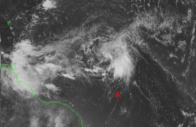
In Late-July, an organized vigorous tropical wave moved off the coast of Africa and quickly gained sufficient characteristics to be classified as Tropical Depression 3 on July 28. The system gradually became better organized and was upgraded to tropical storm strength. Due to the impeding dry air, Chantal remained a minimal tropical storm as it moved towards the Lesser Antilles. The storm briefly intensified to its peak intensity with wind speeds of 50 mph on July 30. However, increasing wind shear caused Chantal to weaken back into a tropical depression. A building ridge forced Chantal away from the Lesser Antilles and to the northwest. On August 1, Chantal briefly regained tropical storm status before again weakening and dissipating on August 2. 
Hurricane Dorian[]
| Category 1 hurricane (SSHWS) | |
  | |
| Duration | August 1 – August 7 |
|---|---|
| Peak intensity | 75 mph (120 km/h) (1-min) 988 mbar (hPa) |
Tropical Storm Erin[]
| Tropical storm (SSHWS) | |
  | |
| Duration | August 16 – August 21 |
|---|---|
| Peak intensity | 50 mph (85 km/h) (1-min) 1000 mbar (hPa) |
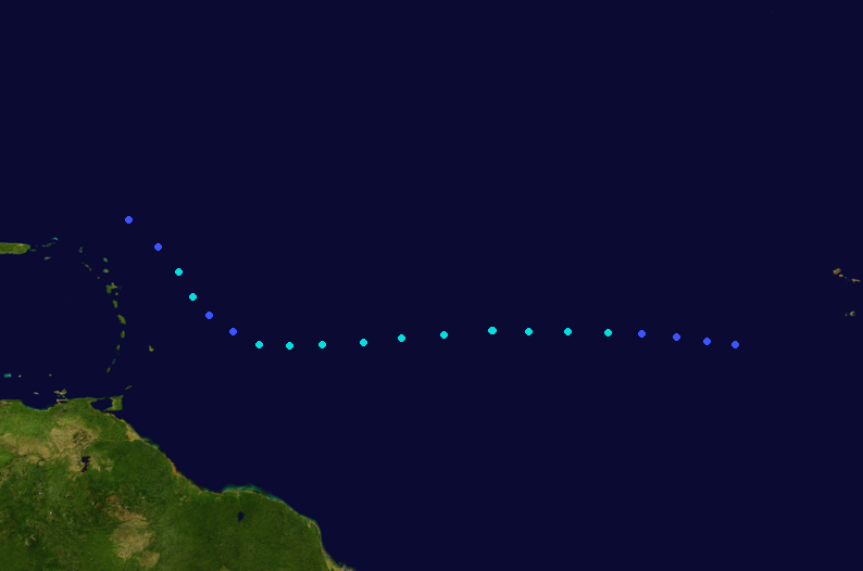
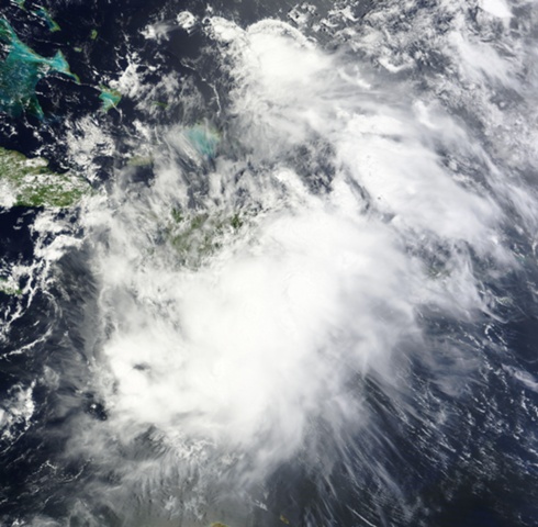
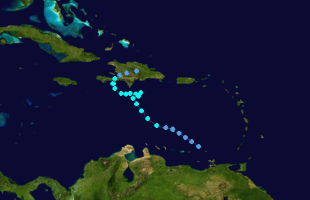
Tropical Storm Erin formed from a monsoonal-type tropical wave that began moving northwards from Venezuela. The wave gained asufficient amount of organization to be classified as a tropical depression on August 16. The depression steadily strengthened to become a tropical storm the next day. As it neared Hispanola, it began to stall just south of the island, bringing as much as a recorded 73.6 inches of rain in suburbs of Port-au-Prince. On August 20 Erin began to move to the north again before making landfall on Haiti and dissipating after losing its identiy over the mountainous terrain.
Due to its torrential rainfall, numerous mudslides were reported across the island. 2,042 deaths, all on the island of Hispanola were contributed to Tropical Storm Erin, the highest number of fatalities in the Atlantic since Hurricane Jeanne of 2004.
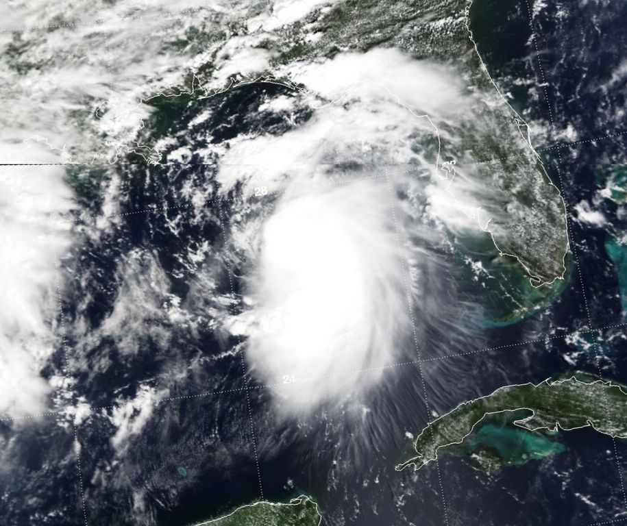
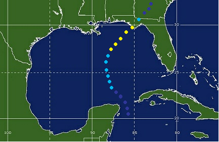
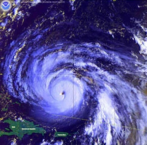
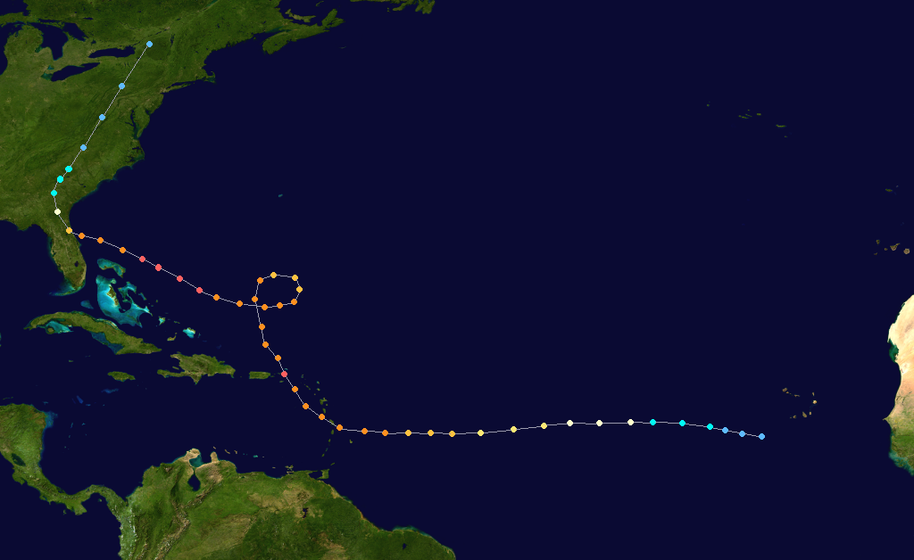
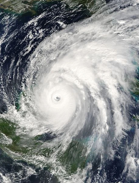
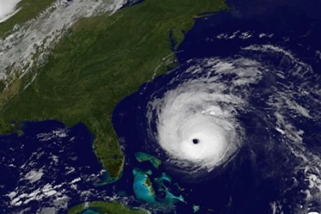
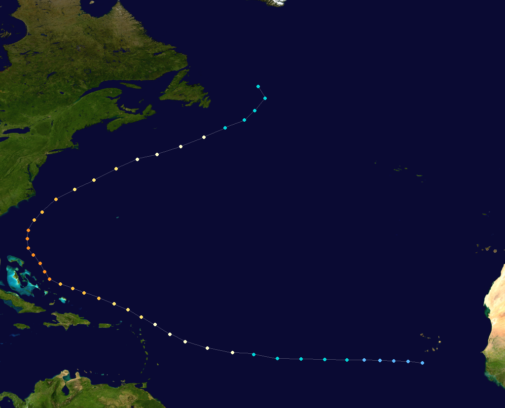
Hurricane Fernand[]
- Main article: Hurricane Fernand
| Category 5 hurricane (SSHWS) | |
  | |
| Duration | August 24 – September 5 |
|---|---|
| Peak intensity | 165 mph (270 km/h) (1-min) 919 mbar (hPa) |
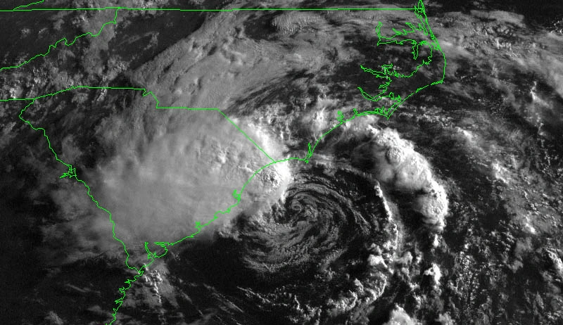
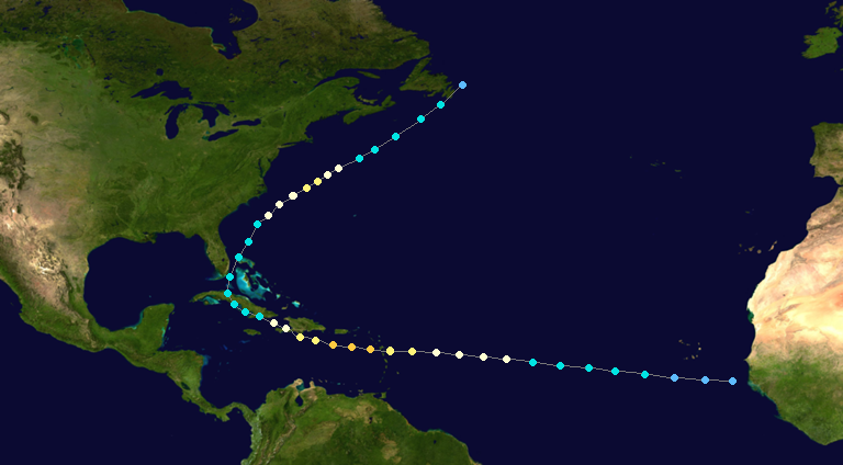
A tropical wave moved off the coast of Africa on August 25, which developed into Tropical Depression Six early on August 24 to the southwest of the Cape Verde islands. Under favorable conditions, the system quickly strengthened into Tropical Storm Fernand late that night, and it continued to gradually intensify within an area of light wind shear and warm waters. Isabel strengthened to a hurricane the next day, and on August 28 it attained major hurricane status. Under the influence of the Azores high Fernand briefly entered the Caribbean Sea and it attained Category 5 hurricane status on the Saffir-Simpson Scale while it was over the Virgin Islands on August 29. Its intensity fluctuated over the subsequent days as it passed north of the Lesser Antilles and made a cyclonic loop before heading west and it attained peak winds of 165 mph (270 km/h) on September 2. On September 3 Fernand made landfall on Daytona Beach in Florida with winds of 135 mph (215 km/h). It continued northwestward, becoming extratropical over northern New York before being absorbed by a larger storm over Ontario on September 7.
As Fernand passed through the Lesser Antilles its powerful storm surge and strong winds eroded much of the island coasts and destroyed numerous structures. When it made landfall on Florida, strong winds from Fernand extended from Florida to North Carolina and westward to Alabama. Numerous power lines were downed, leaving much of the Eastern Seaboard without electricity. Flooding in higher elevated parts of the Continental U.S. washed away many homes and businesses.
Fernand was the first major hurricane to strike the Continental U.S. since Hurricane Wilma in 2005. Fernand also became the second costliest hurricane to hit the US and the costliest hurricane to effect the Lesser Antilles.
Tropical Storm Gabrielle[]
| Tropical storm (SSHWS) | |
  | |
| Duration | September 8 – September 12 |
|---|---|
| Peak intensity | 75 km/h (45 mph) (1-min) 999 hPa (mbar) |
Tropical Storm Humberto[]
| Tropical storm (SSHWS) | |
 | |
| Duration | September 11 – September 16 |
|---|---|
| Peak intensity | 75 km/h (45 mph) (1-min) 1001 hPa (mbar) |
Tropical Depression Nine[]
| Tropical depression (SSHWS) | |
| | |
| Duration | September 13 – September 15 |
|---|---|
| Peak intensity | 55 km/h (35 mph) (1-min) 1007 hPa (mbar) |
Hurricane Ingrid[]
| Category 3 hurricane (SSHWS) | |
 | |
| Duration | September 17 – September 27 |
|---|---|
| Peak intensity | 120 mph (195 km/h) (1-min) 954 mbar (hPa) |
Hurricane Jerry[]
| Category 1 hurricane (SSHWS) | |
| | |
| Duration | September 21 – September 26 |
|---|---|
| Peak intensity | 90 mph (150 km/h) (1-min) 986 mbar (hPa) |
Tropical Storm Karen[]
| Tropical storm (SSHWS) | |
| | |
| Duration | September 21 – September 23 |
|---|---|
| Peak intensity | 65 km/h (40 mph) (1-min) 1004 hPa (mbar) |
Hurricane Lorenzo[]
| Category 4 hurricane (SSHWS) | |
 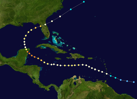 | |
| Duration | September 26 – October 7 |
|---|---|
| Peak intensity | 150 mph (240 km/h) (1-min) 926 mbar (hPa) |
Tropical Storm Melissa[]
| Tropical storm (SSHWS) | |
| | |
| Duration | October 5 – October 10 |
|---|---|
| Peak intensity | 100 km/h (65 mph) (1-min) 1001 hPa (mbar) |
Hurricane Nestor[]
| Category 4 hurricane (SSHWS) | |
  | |
| Duration | October 14 – October 25 |
|---|---|
| Peak intensity | 135 mph (215 km/h) (1-min) 944 mbar (hPa) |
Hurricane Olga[]
| Category 1 hurricane (SSHWS) | |
| | |
| Duration | November 12 – November 17 |
|---|---|
| Peak intensity | 75 mph (120 km/h) (1-min) 997 mbar (hPa) |
Subtropical Storm Pablo[]
| Subtropical storm (SSHWS) | |
| | |
| Duration | December 26 – December 30 |
|---|---|
| Peak intensity | 100 km/h (65 mph) (1-min) 993 hPa (mbar) |
Impact[]
| Storm name |
Dates active | Storm category at peak intensity | Max wind (mph) |
Min. press. (mbar) |
Landfall(s) | Damage (millions USD) |
Deaths | |||||
|---|---|---|---|---|---|---|---|---|---|---|---|---|
| Where | When | Wind
(mph) | ||||||||||
| Andrea | June 15 - June 20 |
Category 1 hurricane | 80 | 981 | Port St. Joe, Florida |
June 19 | 75 | 176.7 | 3 | |||
| Barry | July 2 - July 10 |
Category 2 hurricane | 105 | 968 | Yarmouth, Nova Scotia |
July 9 | 80 | 58 | 7 (1) | |||
| Chantal | July 28 - August 2 |
Tropical storm | 50 | 1000 | No landfall | 0 | 0 | |||||
| Dorian | August 1- August 7 |
Category 1 hurricane | 75 | 988 | Puerto Cabezas, Nicaragua |
August 3 | 60 | 345.3 | 5 | |||
| Costa Maya, Quintana Roo |
August 4 | 40 | ||||||||||
| Tampico, Tamaulipas |
August 6 | 70 | ||||||||||
| Erin | August 16 - August 21 |
Tropical storm | 50 | 1000 | Jacmel, Haiti |
August 20 | 45 | 502 | 2042 | |||
| Fernand | August 24 - September 5 |
Category 5 hurricane | 165 | 919 | Sainte- Luce, Martinque |
August 28 | 140 | 29700 | 595 | |||
| Road Town, British Virgin Islands |
160 | |||||||||||
| Daytona Beach, Florida |
August 3 | 135 | Fernand | August 24 - September 5 |
Category 5 hurricane | 165 | 919 | Sainte- Luce, Martinque |
August 28 | 140 | 29700 | 595 |
| Road Town, British Virgin Islands |
August 29 | 160 | ||||||||||
| Daytona Beach, Florida |
August 3 | 135 | ||||||||||
Storm names[]
|
|
|
The names to the right were used for storms that formed in the Atlantic basin in 2013. This is the same list used in the 2007 season except for Dorian, Fernand, and Nestor, which replaced Dean, Felix, and Noel, respectively and were first used in 2013. Names that were not assigned are marked in gray.
Retirement[]
On May 13, 2014, at the 36th Session of the World Meteorological Organization's Regional Association IV Hurricane Committee, the WMO retired the names Erin, Fernand, and Lorenzo from its rotating name lists. The names were replaced with Eddison, Faustus, and Largo.