The 2048 Indian Ocean Cyclone Season is an event in the annual cycle of tropical cyclone formation. The North Indian Ocean cyclone season has no official bounds, but cyclones tend to form between April and December, with the peak from May to November. These dates conventionally delimit the period of each year when most tropical cyclones form in the northern Indian Ocean.
The scope of this article is limited to the Indian Ocean in the Northern Hemisphere, east of the Horn of Africa and west of the Malay Peninsula. There are two main seas in the North Indian Ocean — the Arabian Sea to the west of the Indian subcontinent, abbreviated ARB by the India Meteorological Department (IMD); and the Bay of Bengal to the east, abbreviated BOB by the IMD. The official Regional Specialized Meteorological Centre in this basin is the India Meteorological Department (IMD), while the Joint Typhoon Warning Center releases unofficial advisories. On average, three to four cyclonic storms form in this basin every season.
The season officially had an early start compared with the last one season, with the formation of Cyclone Ogni near Iran in mid-May. Cyclone Agni, formed in one of June over the Bay of Thailand. At its peak intensity, it was equivalent to a Category 3 hurricane on the Saffir-Simpson hurricane wind scale. The cyclone produced severe flooding in the north of Malaca peninsula.originally the storm formed in the Pacific and there reached its peak of intensity, but crossed the thin peninsula of Malacca and reached the Indian Ocean as a tropical storm, it is considered to be category 3 and not a tropical storm by the storm tracking center Thai, in the Pacific received the name of Bising.
Despite the season's early start, the 2048 season was a extremely active season with a total of 15 tropical depressions, of which 13 became tropical storms. After five months of the start of 2048, the first tropical depression developed on May 17, making it the fifth-earliest season for a system to form. According to existing records only four other seasons started later—the 2018, 2021, 2022 and 2037 seasons. Tropical activity throughout the basin became very favorable for development at June,one tropical storm and two Extremely Severe Cyclonics storms developed during June. On July 1, Baar became the first category 4 cyclone making it the earliest first cat 4 storm on record.Baar reached Category 4 intensity in Fujita scale before making landfall in North Oman and Iran, causing a total of unknow number of damage. In mid July, Fanoos reached its peak intensity while making landfall over Sri Lanka.The storm caused a total of US$2,8 billion of damage in Sri Lanka and Southern India. Shortly later, Mala reached tropical storm intensity; it affected Sri Lanka but its damage was minimal.The season became more active in late July, with the Super Cyclonic Storm Nisha. At the beginning of August the category five Bijli cyclone, which caused serious damage in Thailand, was followed by Land Storm 09, which made history, since it was the first land depression to reach the category of cyclonic storm, causing terrible floods, with more than 30 billion dollars lost and more than 2000 lifes.
On August 13, a tropical storm in the Pacific formed and began to fall in latitude, reached latitude 4.8 and reached category one, the south of the Malay Peninsula, causing significant damage in Indonesia, Thailand and Singapore. also leaving very intense rainfall throughout the region.only one day later the storm Ward was formed, which became a category 5 cyclone and an impact on the south of Yemen, causing damage to Yemen, some incidents in Saudi Arabia, Somalia and Eritrea, dissipating very close to African lands.
On September 4, a powerful tropical wave was developed explosively near the Indian, reaching category 4, due to the unexpected phenomenon, the losses were large, but not too many people died, compared to other storms of the season, surely. because the area was not very populated, in September two more depressions were formed, BOB 15 reached latitude 1.2, absolute record and came to affect Ethiopia and caused considerable damage in Somalia. The last storm of the season was the circulation of a historic typhoon in Pacific, which managed to maintain its circulation in the Southeast Asian region and generated depression BOB 16, which survived two days in the Indian before dissipating.
Seasonal forecast
| TSR forecasts Date |
Tropical storms |
Total
cyclones |
! Intense TCs |
ACE | Ref |
|---|---|---|---|---|---|
| Average (1965–2047) | 8 | 5 | 2 | 297 | [1] |
| May 5, 2048 | 10 | 6 | 3 | 357 | [1] |
| July 6, 2048 | 13 | 10 | 5 | 250 | [2] |
| August 8, 2048 | 11 | 8 | 3 | 255 | [3] |
| Other forecasts Date |
Forecast Center |
Period | Systems | Ref | |
| January 20, 2048 | PAGASA | January — March | 0-1 tropical cyclones | [4] | |
| January 20, 2048 | PAGASA | April — June | 2–4 tropical cyclones | [4] | |
| June 26, 2048 | CWB | January 1 — December 31 | 8–12 tropical storms | [5] | |
| July 6 ,2048 | PAGASA | July — September | 6–9 tropical cyclones | [6] | |
| July 6 ,2048 | PAGASA | October — December | 0–1 tropical cyclones | [6] | |
| 2048 season | Forecast Center |
Tropical cyclones |
Tropical storms |
Severe Storms | Ref |
| Actual activity: | JMA | 8 | 4 | 1 | |
| Actual activity: | JTWC | 13 | 7 | 3 | |
| Actual activity: | PAGASA | 10 | 8 | 4 | |
Timeline

Cyclonic Storm Ogni
| Cyclonic storm (IMD) | |
| Tropical storm (SSHWS) | |
  | |
| Duration | May 17 – May 20 |
|---|---|
| Peak intensity | 85 km/h (50 mph) (3-min) 990 hPa (mbar) |
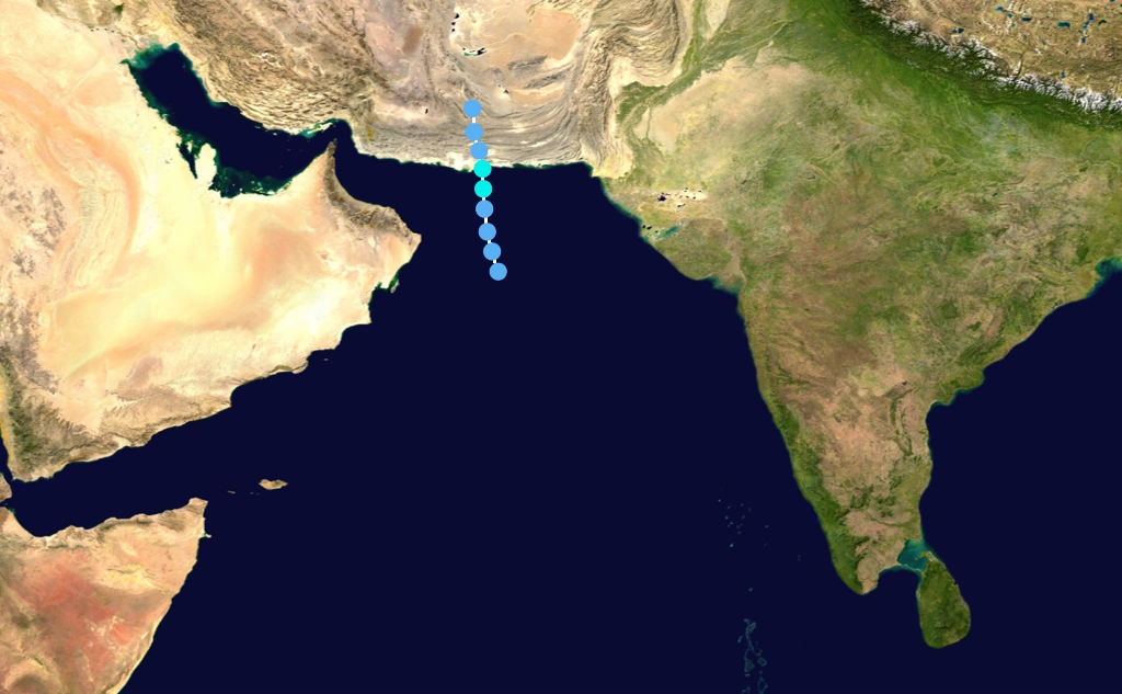
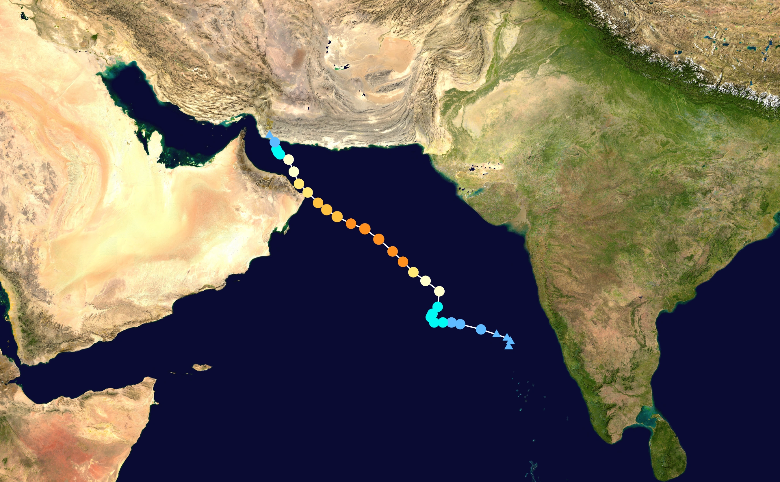
Toward the middle of May 2048, a surge in the monsoon produced widespread convection, or thunderstorms, off the coast of India in the northwestern Arabian Sea. After a low-level circulation became evident on May 17, the India Meteorological Department (IMD) designated the system as a low pressure area. The low moved northwestward within an area of warm water temperatures of 30 to 32 °C (86 to 90 °F), moderate wind shear, and an upper-level environment conducive for tropical cyclogenesis, The Joint Typhoon Warning Center (JTWC) first noted the system on May 15 as an area of potential development. The circulation became more defined within the building convection, which was amplified by outflow from an anticyclone over the Iran, At 03:00 Coordinated Universal Time (UTC) on May 31, the IMD designated the system as a depression about 1,000 km (620 mi) west of Mumbai, India, or about 260 km (85 mi) east of Muscat, Oman. At 18:00 UTC, the JTWC began issuing advisories on the storm, designating it as Tropical Cyclone 01A.
As the wind shear increased, it turned north around the ridge. High mountains in southern Iran weakened Ogni, causing the structure to become more asymmetrical. On May 20, the depression weakened into a remnant low near Madhya Pradesh.
Ogni caused 8 deaths and cost almost 100 million of dollars in damages.
Very Severe Cyclonic Storm Agni
| Very severe cyclonic storm (IMD) | |
| Category 3 tropical cyclone (SSHWS) | |
  | |
| Duration | June 1 – June 6 |
|---|---|
| Peak intensity | 155 km/h (100 mph) (3-min) 958 hPa (mbar) |
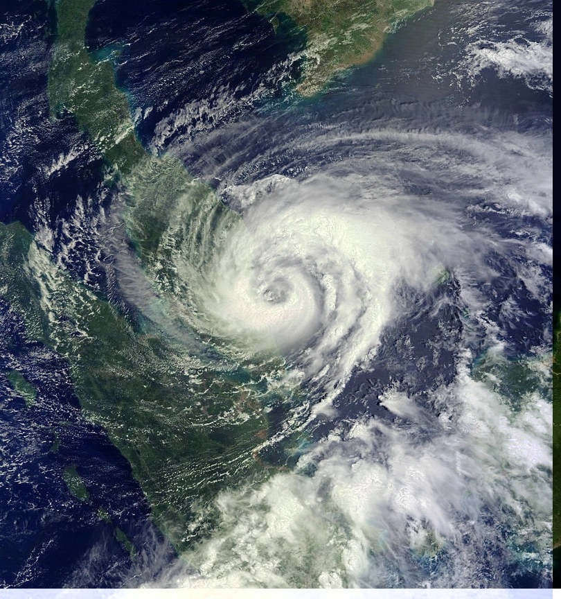
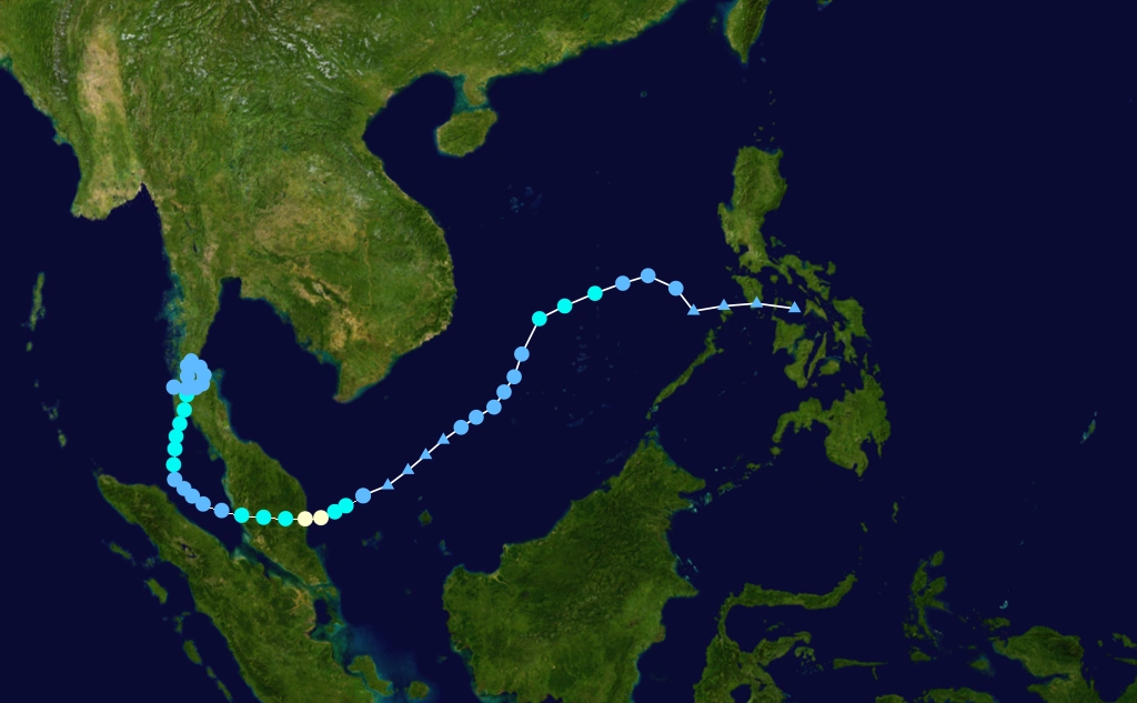
Typhoon Reming formed as a tropical depression on June 1 near Brunei.Situated south of a ridge, the system tracked west through a region of low wind shear and good upper-level divergence. Late on June 2, the depression intensified into a tropical storm and was named Reming by the Japan Meteorological Agency (JMA) Steady strengthening took place over the following two days as the system approached the Vietnam. After attaining typhoon status, the storm underwent a period of rapid intensification,culminating with it attaining peak 10 minute maximum sustained winds of 155 km/h (100 mph) and a barometric pressure of 958 mbar (hPa; 18.04 inHg). Reming brushed the southern coast of the Vietnam.
It weakening took place before the storm made landfall in the northern of Malaca peninsula.Land interaction precipitated further degradation of storm, though it lossed typhoon status upon emerging when it crossed Malay Peninsula.The JMA ceased tracking the storm on June 4 when it crossed west of 100° E,although the Joint Typhoon Warning Center (JTWC) continued tracking it through the Bay of Bengal. Failing to reorganize, the recently named Agni degenerated into a remnant low on June 6 before ultimately dissipating one day later off the coast of Thailand.
The storm caused severe damages in southern Thailand,Malasia and Vietnam,killing 24 persons and causing an undetermined number of economical losses.
Cyclonic Storm Hibaru
| Cyclonic storm (IMD) | |
| Tropical storm (SSHWS) | |
  | |
| Duration | June 14 – June 18 |
|---|---|
| Peak intensity | 85 km/h (50 mph) (3-min) 999 hPa (mbar) |
On June 14, a westward-moving disturbed area of weather formed about 885 nm east of Cape Guardafui, Somalia was designated Depression ARB 03/2048 by the IMD. The next day, the Joint Typhoon Warning Center designated the depression as Tropical Cyclone 05A. Soon after, the IMD upgraded the depression to a deep depression. The Deep Depression did not develop and degenerated into a low pressure area on June 18 as it moved further west. Hibaru in Laskwadeep Islands received 70 mm of rainfall.
Extremely Severe Cyclonic Storm Pyarr
| Extremely severe cyclonic storm (IMD) | |
| Category 3 tropical cyclone (SSHWS) | |
  | |
| Duration | June 28 – July 3 |
|---|---|
| Peak intensity | 165 km/h (105 mph) (3-min) 949 hPa (mbar) |
On June 26, an area of disturbed weather developed southeast of the Andaman Islands, with a weak low-level circulation near the Nicobar Islands. Initially moderate upper-level wind shear inhibited organization, while strong diffluence aloft aided in developing convection. Vertical shear decreased greatly as the circulation became better defined, and a Tropical Cyclone Formation Alert was issued on June 28,while located a short distance south of the Andaman Islands. Around the same time, the India Meteorological Department (IMD) designated the system as Depression BOB 04. The Joint Typhoon Warning Center (JTWC) upgraded it to Tropical Cyclone 04B after Dvorak estimates indicated winds of 55 km/h (35 mph). Later that day, it intensified into a deep depression as it moved slowly north-westward.
The IMD upgraded the system to Cyclonic Storm Pyar early on July 1 The system then began to intensify quickly as it moved slowly northwestward, and the IMD upgraded it to a severe cyclonic storm later that day, and a very severe cyclonic storm early the next day. On the morning of November 15, the cyclone intensified to reach peak winds of 165 km/h (105 mph) according to the IMD. It weakened quickly after landfall and the final advisories were issued early on July 3.
Coastal districts of Bangladesh faced heavy rainfall as an early impact of the cyclone. Dhaka and other parts of Bangladesh experienced drizzle and gusty winds. Total damages in the region came close to US$450 million.
Storm surges reaching up to a height of 3 metres (9.8 ft) were reported in the coastal areas of north Chennai in southern state of Tamil Nadu in India, triggering panic among the fishing community.
The damage in Bangladesh was extensive, including tin shacks flattened, houses and schools blown away and enormous tree damage.The entire cities of Patuakhali, Barguna and Jhalokati District were hit hard by the storm surge of over 5 meters (16 ft). About a quarter of the world heritage site Sunderbans were damaged. Researchers said mangrove forest Sunderban will take at least 40 years to recover itself from this catastrophe. Much of the capital city of Dhaka was also severely affected, as electricity and water service were cut and significant damage was reported there due to winds and flooding. The local agricultural industry was also devastated, as many rice crops.
At least 127 deaths and US$750 million in damages were reported.
Extremely Severe Cyclonic Storm Baaz
| Extremely severe cyclonic storm (IMD) | |
| Category 4 tropical cyclone (SSHWS) | |
  | |
| Duration | July 1 – July 6 |
|---|---|
| Peak intensity | 205 km/h (125 mph) (3-min) 932 hPa (mbar) |
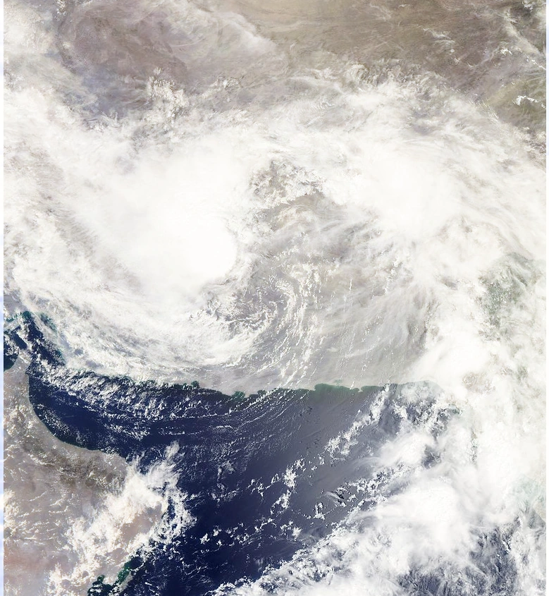
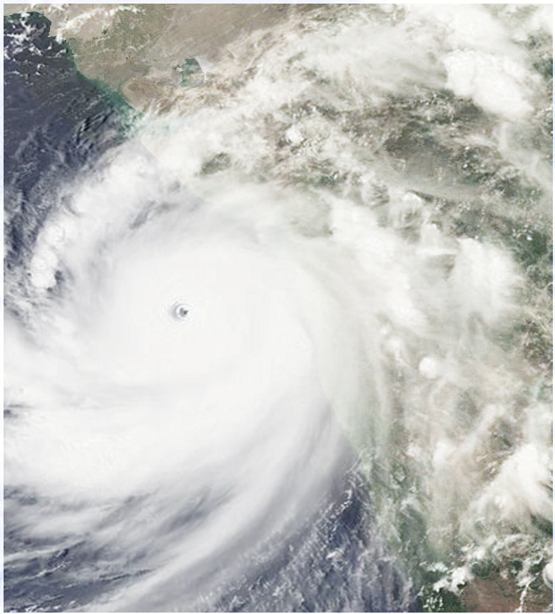
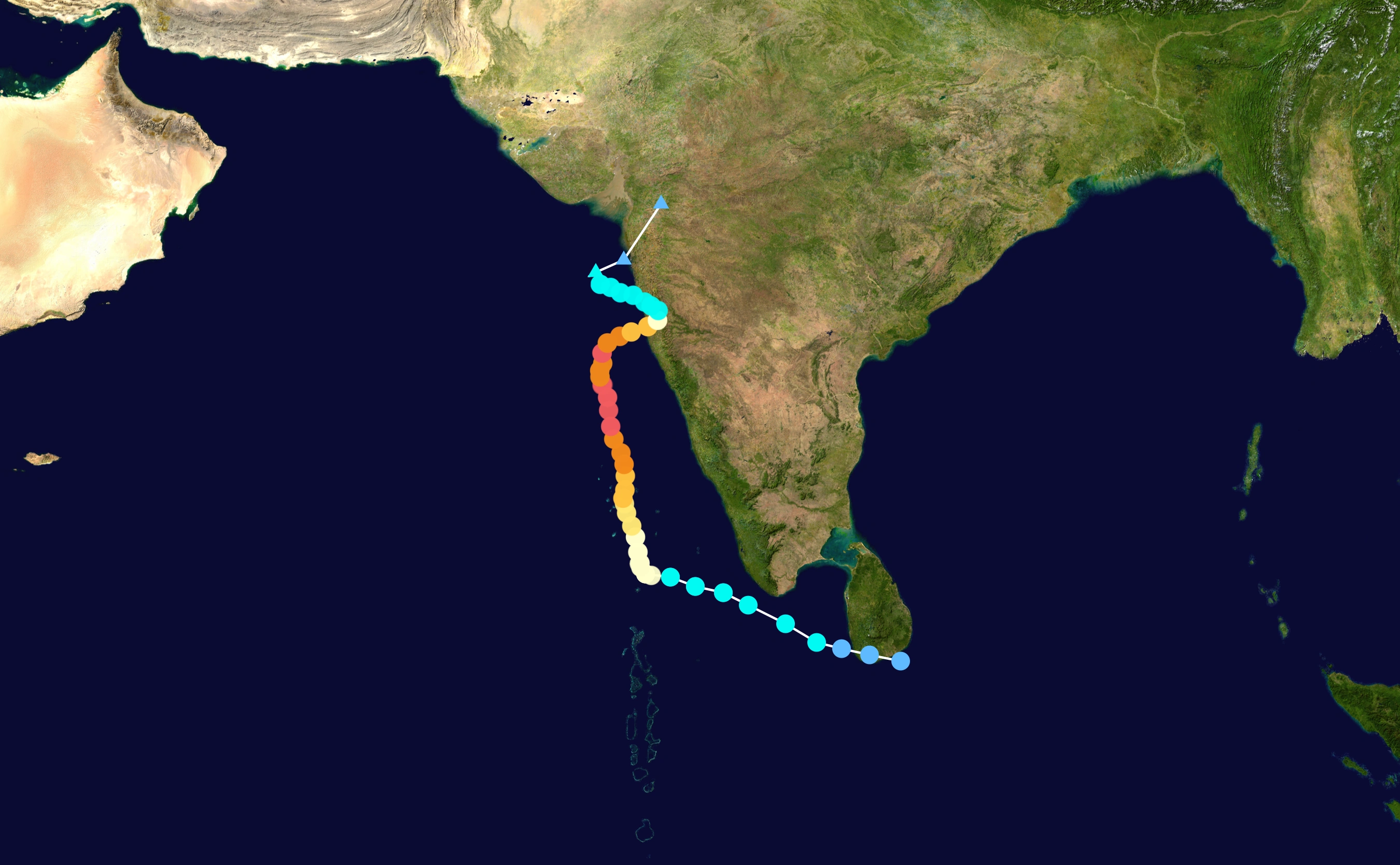
Toward the end of June, the monsoon trough spawned a low pressure area in the eastern Arabian Sea. By June 31, an organized tropical disturbance was located about 645 km (400 mi) south of Mumbai, India, with cyclonic convection, or thunderstorm activity, and a well-defined mid-level circulation. The disturbance initially lacked a distinct low-level circulation; instead it consisted of strong divergence along the western end of a surface trough of low pressure.A very favorable upper-level environment allowed convection to improve, and by late on July 1, the system developed to the extent that the India Meteorological Department (IMD) classified it as a depression. It tracked westward along the southwestern periphery of a mid-level ridge over southern India. Convection continued to organize, and early on July 5 the Joint Typhoon Warning Center (JTWC) classified it Tropical Cyclone 05A about 685 km (425 mi) southwest of Mumbai.
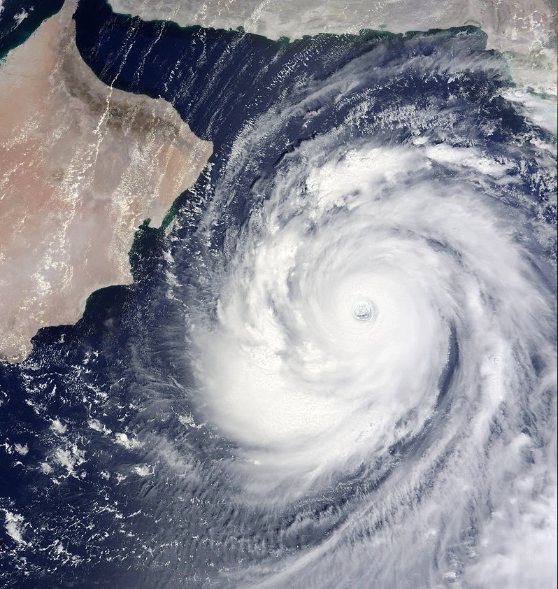
Upon first forming, the system contended with the entrainment of dry air to the northwest of the storm, which was expected to limit intensification.The storm steadily intensified, and early on July 2, the IMD upgraded it to deep depression status. Later in the day the IMD classified the system as Cyclonic Storm Baaz about 760 km (470 mi) southwest of Mumbai, India.As a mid-latitude trough developed over Pakistan, Baaz turned to the north and northeast, though it resumed a westward track after ridging built to the north of the storm. With a solid area of intense convection, it rapidly intensified to attain severe cyclonic status early on July 3, and with good outflow the JTWC upgraded it to the equivalent of a hurricane category 1,The dry air ultimately had a smaller impact on the intensification than previously estimated. A well-defined eye developed in the center of convection, and after moving over a local increase in ocean heat content, Baaz rapidly deepened. Late on July 3, the IMD upgraded the storm to Very Severe Cyclonic Storm Baaz. With warm waters, low amounts of vertical wind shear, and favorable upper-level outflow, Gonu strengthened further to attain peak 1-min sustained winds of 205 km/h (125 mph) ,about 285 km (175 mi) east-southeast of Masirah Island on the coast of Oman.
After the storm maintained peak winds for about twelve hours, the IMD downgraded Gonu to very severe cyclonic storm status late on July 4. Its eye became cloud-filled and ragged, and the cyclone gradually weakened due to cooler water temperatures and drier air as it approached the Arabian Peninsula. Due to land interaction with Oman, the inner core of deep convection rapidly weakened, and over a period of 24 hours the intensity decreased,the storm crossed the easternmost tip of Oman still as a very severe cyclonic storm late on July 5.Although the winds continued to gradually decrease, overall organization increased slightly in the hours prior to landfall.
However, increasing wind shear and entrainment of dry air from the Arabian Peninsula continued to remove deep convection from its eastern semicircle.On July 6, the cyclone turned to the north-northwest,and later that day the JTWC downgraded Baaz to tropical storm status.The storm crossed the Makran coast in Iran six hours later, and the IMD stopped issuing advisories on the cyclone.This made it the first tropical cyclone on record to hit the country since 2024. After landfall,the storm finaly dissipated late on July 6.
Across its path, the cyclone caused heavy damage and many fatalities. Baaz began affecting the country with rough winds and heavy precipitation; rainfall totals reached 610 mm (24 in) near the coast.the storm produced strong waves along much of the coastline,leaving many coastal roads flooded.There was a 5.1 meter (17 foot) storm surge and a 200 m (660 ft) incursion of seawater inland at Ras al-Hadd; other areas along the coast had similar levels.
For the effective preparations,the storm only caused 3 deaths and damages still being unknow.
Extremely Severe Cyclonic Storm Fanoos
| Extremely severe cyclonic storm (IMD) | |
| Category 3 tropical cyclone (SSHWS) | |
  | |
| Duration | July 12 – July 20 |
|---|---|
| Peak intensity | 165 km/h (105 mph) (3-min) 958 hPa (mbar) |
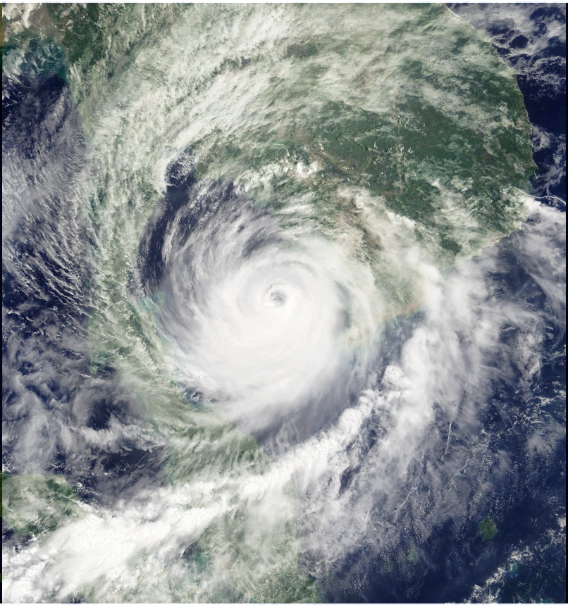
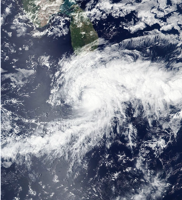
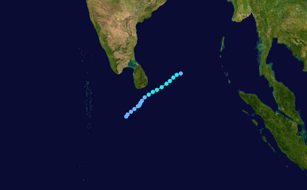
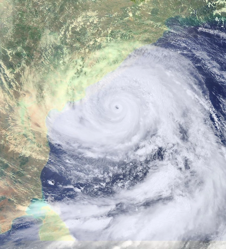
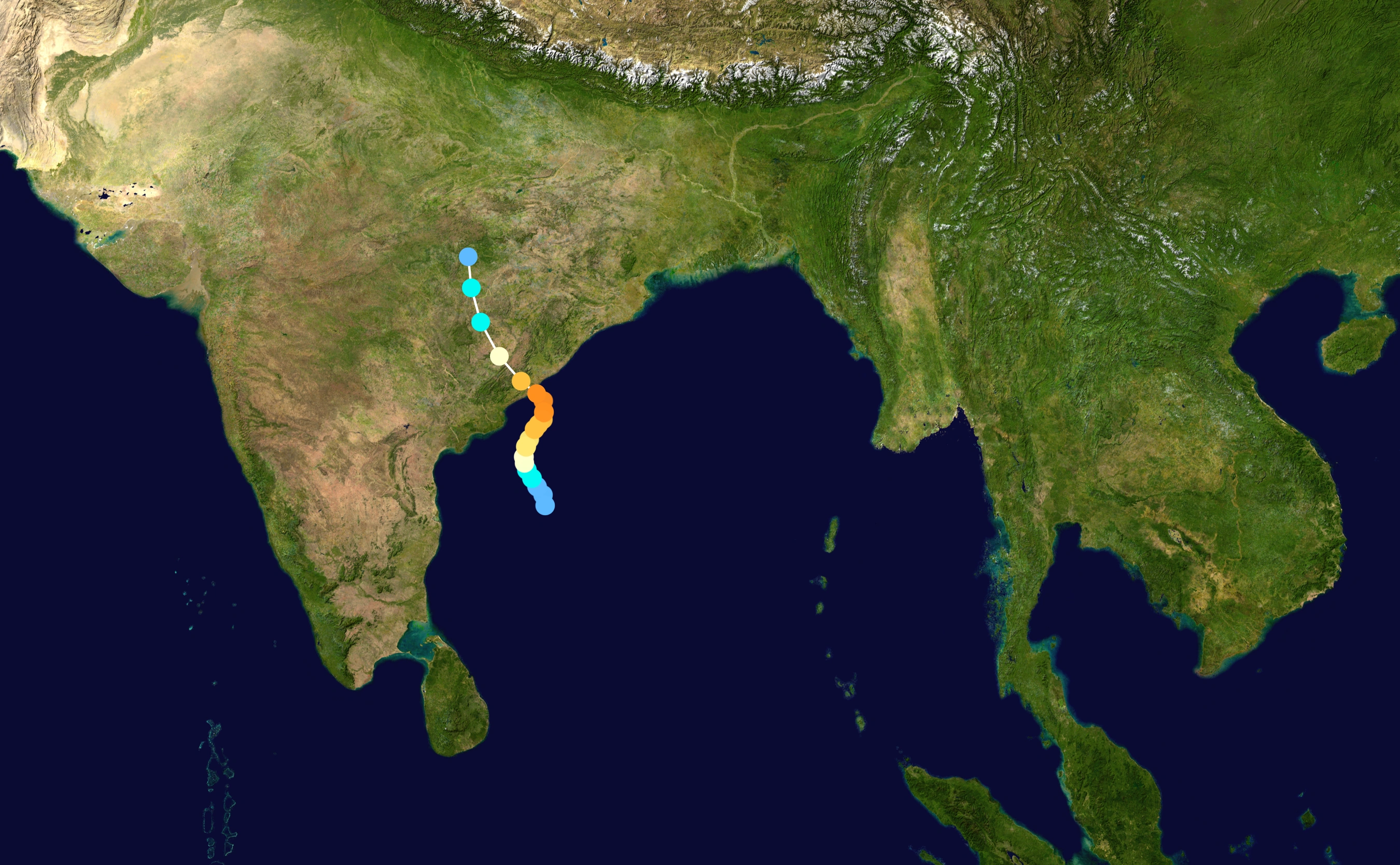
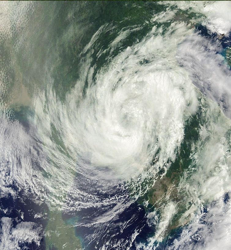
An area of atmospheric convection developed and persisted on July 10 in the central Bay of Benga,forming within an active near-equatorial trough.Located within an area of weak vertical wind shear, the system steadily organized, and after initially remaining nearly stationary it began to move slowly westward. Deep convection continued to develop, and on July 11 a mid-level circulation began to form. Later that day, the Joint Typhoon Warning Center (JTWC) issued a Tropical Cyclone Formation Alert, the India Meteorological Department (IMD) classifying it as a deep depression early on July 12 Later that day, the organization of the system degraded slightly, though it quickly reorganized. On July 14, the Joint Typhoon Warning Center initiated advisories on Tropical Cyclone 06B while it was located about 155 miles (250 km) east of Sri Lanka. On the center's first advisory, the tropical storm was drifting west-northwest at 3 mph (5 km/h) with maximum sustained winds of 45 mph (70 km/h). Shortly thereafter, the IMD upgraded the deep depression to a cyclonic storm as a central dense overcast developed over the center. A subtropical ridge to the north of the cyclone resulted in it continuing generally westward. Deep convection continued to develop over the center of circulation, and the storm steadily strengthened as outflow improved throughout the circulation, a rainband wrapped tightly into the center, and it intensified into a extremely severe cyclonic storm as it approached the coast of Sri Lanka. The next day the cyclone made landfall on near Trincomalee, Sri Lanka. The JTWC assessed the cyclone as attaining peak winds of 105 mph (165 km/h). It weakened over land and dissipating over coast of India on July 20.
Government officials in Sri Lanka issued a last-minute evacuation order for potentially affected areas, though few received the evacuation order. The cyclone hit the eastern and western coastlines with powerful waves, wrecking 105 fishing boats in eastern coastal towns,The cyclone was accompanied with a storm surge as made landfall that flooded areas up to 330 feet (100 m) inland. While crossing the country, the cyclone dropped between 4 and 8 inches (100 to 200 mm) of precipitation, compounding the effects of severe monsoonal flooding from the previous month, Wind gusts from the cyclone reached 110 mph (175 km/h) near where it made landfall.the storm produced almost 2,8 billion of dollars in loses and killed a undetermined number of people.
Cyclonic Storm Mala
| Cyclonic storm (IMD) | |
| Tropical storm (SSHWS) | |
  | |
| Duration | July 19 – July 23 |
|---|---|
| Peak intensity | 65 km/h (40 mph) (3-min) 994 hPa (mbar) |
A low pressure area developed in the Intertropical Convergence Zone near Sri Lanka on July 18 Early on July 19, the system developed into a depression. The JTWC issued a TCFA at 1251 UTC on July 19, while it was centered 340 kilometres (210 mi) south-southeast of Sri Lanka. By 1800 UTC on July 20, the JTWC initiated advisories on Tropical Cyclone 07B, which was located about 160 km (100 mi) southeast of Dondra Head, Sri Lanka. At that time, the storm had intensified into a deep depression. Further strengthening occurred, and it was upgraded to a cyclonic storm early on July 21
After peaking with maximum sustained winds of 65 km/h (40 mph) and a minimum barometric pressure of 994 mbar (26.4 inHg) on July 21, the storm soon weakened and convection diminished, possibly due to interaction with a nearby tropical disturbance.By early on the following day, it was downgraded to a deep depression while moving toward the northeast. Later that day, Cyclonic Storm BOB 06 weakened to a depression. At 1800 UTC on July 23, the JTWC issued a final advisory on the cyclone, citing that it degenerated into a remnant low pressure area while located about 685 km (425 mi) east-southeast of Dondra Head, Sri Lanka.
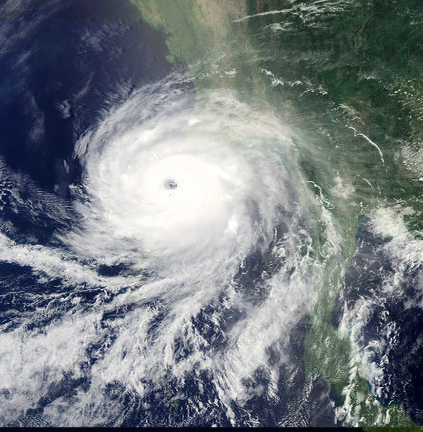
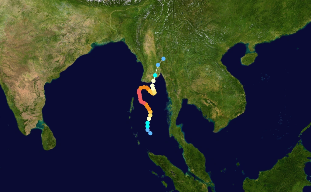
Super Cyclone Storm Nisha
| Super cyclonic storm (IMD) | |
| Category 5 tropical cyclone (SSHWS) | |
  | |
| Duration | July 26 – August 8 |
|---|---|
| Peak intensity | 220 km/h (140 mph) (3-min) 902 hPa (mbar) |
Late on July 24, the Joint Typhoon Warning Center (JTWC) reported that an area of convection had started to deepen around a poorly organized and elongated low level circulation center about 40 km (20 mi), to the southwest of Colombo in Sri Lanka.[ The low level circulation center was located in a region of upper level,divergence which was providing a good channel for outflow, it was also located in an area of high levels of water temperatures, During the next couple of days the disturbance gradually developed whilst moving around a subtropical ridge of pressure before the disturbance moved offshore in India during July 29 and became more marked as it moved out into the warm waters of the Arabian Sea during the next day.Early on July 30,the system dryfed north and started to intensify.
The JTWC reported that the depression had intensified into a very severe cyclonic storm, the storm keept organized deep convection increased around a consolidating a eye. Early the next day the IMD reported that the cyclone had intensified into a Super Cyclone as convection organized further. The IMD further reported later that day that the deep depression had reached its peak windspeeds of 220 km/h (140 mph) 3-min sustained. the Cyclone made landfall in Maharashtra between Alibagh and Mumbai later in August 6.Later that day as the low level circulation center had rapidly detached from the deep convection the JTWC issued their final advisory whilst the IMD reported that Phyan had weakened into a depression before downgrading it to a well marked area of low pressure over India on August 8.
Nisha caused heavy rainfall in east coast of India. Kethi in Nilgiris district of Tamil Nadu recorded 122 cm of rainfall in 24 hours, making it the 3th wettest cyclone in India. Winds were strong, but the rain caused most of the damage. The storm killed 1,352 people and caused around US$3.6 billion, making it one of the deadliest and costliest cyclones of the season.
Super Cyclone Storm Bijli
| Super cyclonic storm (IMD) | |
| Category 5 tropical cyclone (SSHWS) | |
  | |
| Duration | August 4 – August 11 |
|---|---|
| Peak intensity | 250 km/h (155 mph) (3-min) 898 hPa (mbar) |
Cyclone Bijli was first identified by the India Meteorological Department (IMD) as an area of low pressure over the Bay of Bengal on August 2. Early the system was classified as a depression and given the name BOB 08; and at that time, the system was situated roughly 250 km (155 mi) southwest of Nicobar islands Continued development took place as convection consolidated around the system and banding features formed along the western side of the low. As the depression was situated in an area of weak wind shear, further development was anticipated over the following days. Early on August 6, the IMD upgraded the system to a deep depression and expected it to further intensify into a cyclonic storm within 24 hours.The system rapidly developed throughout the day on August 7, developing an eye embedded within deep convection. In response to a near-equatorial ridge to the south, the system slowly tracked towards the northeast, placing Thailand within its path. Around 0600 UTC, the IMD upgraded the system to a very severe cyclonic storm.
Tracking over an area of very high sea surface temperatures, rapid intensification ensued during the latter half of August 8. Following the development of very intense convection,the storm strengthened into a super cyclonic storm, having sustained winds of at least 250 km/h (155 mph 3-minute sustained).Around 1800 UTC, the JTWC estimated that the system intensified into a Category 5 equivalent cyclone on the Saffir–Simpson Hurricane Scale. Early on August 9,the storm drifted towards the south coast of Thailand. Throughout the day,the storm underwent explosive weakening, Once overland, the cyclone rapidly decayed as convection dissipated. Despite having estimated winds of 150 km/h (90 mph 1-minute sustained), the JTWC issued their final advisory on Bijli just six hours after landfall. By early October 23, only scattered bursts of convection remained around the center of Bijli as it degenerated into a tropical depression.The final advisory from the IMD was issued later that day as the system weakened further. According to local media, Cyclone Bijli brought a storm surge up to 3.7 m (12 ft), along with waves up to 8 m (26 ft) and winds in excess of 200 km/h (120 mph) In Kyaukphyu, much of the city was left more than 1.2 m (3.9 ft) under water by the storm. Residents stated that most of Kyaukphyu was destroyed by, with nearly every tree and lamppost felled and all structures damaged or destroyed.Later reports confirmed that roughly 70% of the city had been destroyed by Bijli. In the Ashey Paing ward, an entire village was flattened by the storm as roughly 1,000 homes were destroyed. Near the Gangawtaw Pagoda in Kyaukphyu, nearly 100 homes were completely destroyed.The local Red Cross office in the city was also destroyed after a large tree fell on it due to high winds.Myebon Township was the hardest-hit area in the country: several villages were completely destroyed by the storm and many others were severely damaged.According to the United Nations, roughly 15,000 homes were destroyed by the storm throughout Rakhine State.
Overall, 745 deaths and US$1.5 billion in damages were reported.
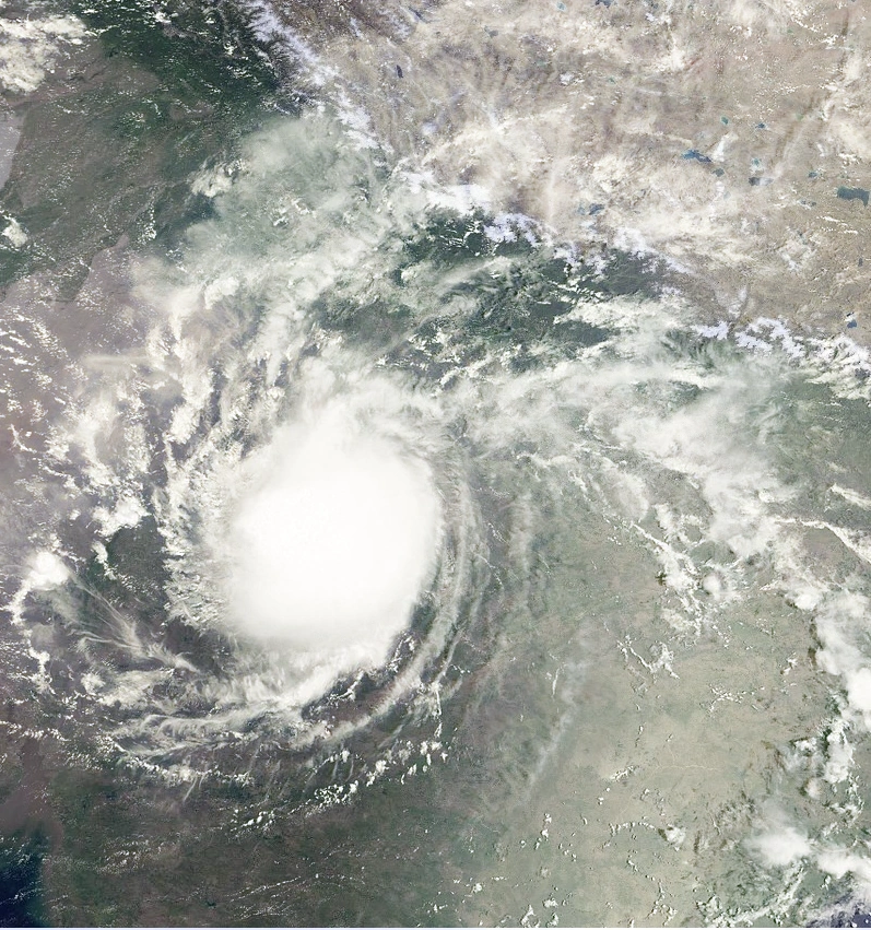
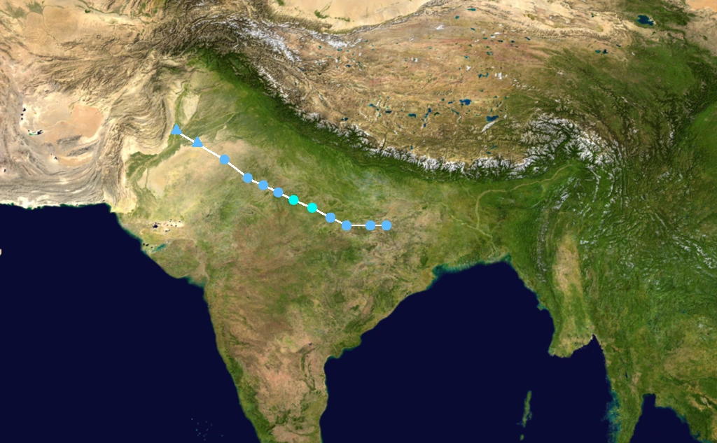
Land Storm 09
| Cyclonic storm (IMD) | |
| Tropical storm (SSHWS) | |
  | |
| Duration | August 12 – August 15 |
|---|---|
| Peak intensity | 85 km/h (50 mph) (3-min) 988 hPa (mbar) |
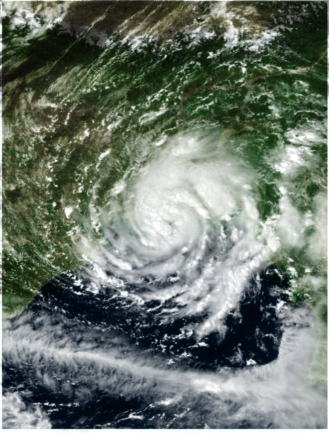
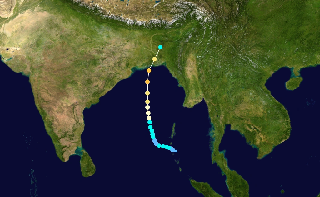
On August 11 as the Madden–Julian oscillation entered its fifth phase, the Bay of Bengal became favourable for tropical cyclogenesis.As a result of this and an upper tropospheric cyclonic vortex, an area of low pressure developed on August 12, over the Gangetic West Bengal about 50 km (30 mi) to the southeast of Daltonganj. During the next day the IMD reported that the low pressure area had intensified into a land depression, with peak 3-minute sustained windspeeds of 85 km/h (50 mph),setting the record of the most intense land depression. During that day, the depression moved towards the northwest under the influence of a monsoon trough before it weakened into a low pressure area during August 15, Under the influence of the system, the Indian states of Madhya Pradesh, Rajasthan, Gujarat, Chhattisgarh and Vidarbha saw incredibily heavy rainfall,the floods of Ganges caused above of 2000 deaths and 30 billions of damages,making this storm the deadliest of season and one of the most deadly storm in years in this basin.
Very Severe Cyclonic Storm Pyan
| Very severe cyclonic storm (IMD) | |
| Category 1 tropical cyclone (SSHWS) | |
  | |
| Duration | August 13 – August 21 |
|---|---|
| Peak intensity | 120 km/h (75 mph) (3-min) 978 hPa (mbar) |
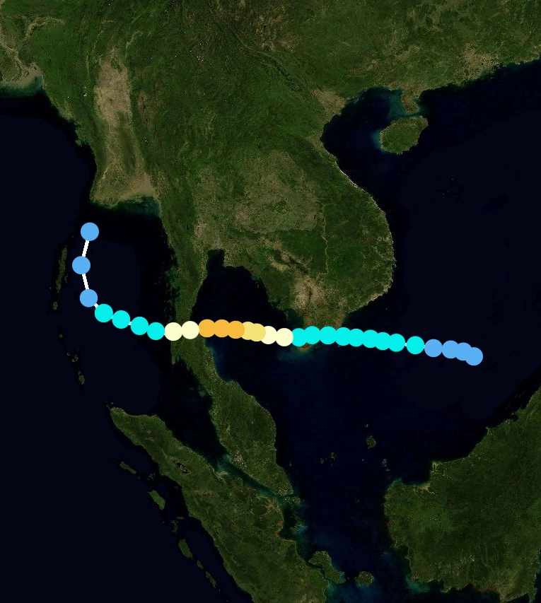
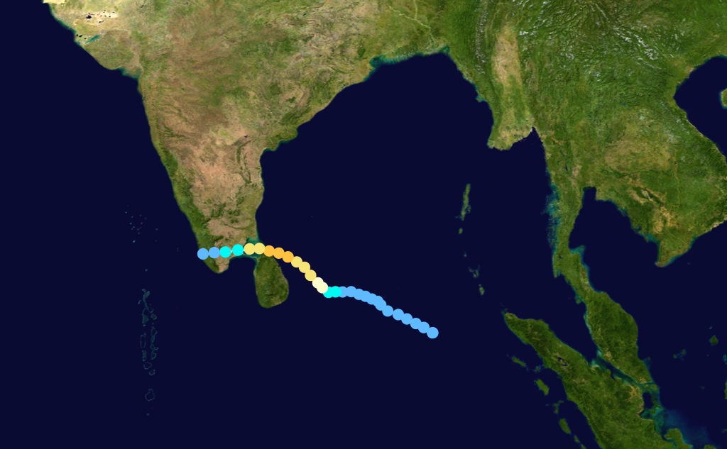
On August 12, a small low-level circulation was located along the northwest coastline of Phillipine; at the same time a plume of hot air progressed southward through the South China Sea on the southeastern periphery of a ridge over the Far East. The vortex drifted southwestward, reaching open water by August 14. The northerly air surge was deflected after interacting with the circulation, and at the same time a portion of the air surge crossed the equator. The southerly flow turned eastward, then northward, and in combination with the northerly flow it wrapped into the vortex, resulting in rapid development of the low-level circulation, just a short distance north of the equator. By August 15, an area of scattered convection persisted about 370 km (230 mi) east of Singapore within an area of low wind shear, in association with the low-level circulation. Continuing slowly westward, the convection deepened and organized further,become an a very severe cyclonic storm near indian ocean.
The cyclone strengthened further.Tropical Storm Pyan weakened quickly as it crossed the southern portion of the Malay Peninsula, and late onAugust 18 the JMA downgraded it to tropical depression status before the cyclone emerged into the Straits of Malacca.The JTWC initially maintained it as a minimal tropical storm, though the agency downgraded the storm to depression status as the center again, convection persisted near the circulation over land, believed to have been caused by the process known as upper-level diffluence. On August 19, what was originally believed to be a separate system reached thenorth of Malaca peninsula. In a post-season re-evaluation, the JTWC classified the system as a continuation of Pyan,but the storm stayed on land and dissipated over land on August 21. Offshore of Malaysia, two U.S. Navy ships in Vamei's eyewall were damaged by strong winds. Upon moving ashore, the storm brought storm surge damage to portions of southeastern Peninsular MalaysiaThe storm brought strong winds and heavy rainfall to portions of Melaka, Negeri Sembilan, and Selangor as well as to Johor, where rainfall reached over 200 mm (8 in) in Senai. Additionally, monsoonal moisture, influenced by the storm, produced moderate to heavy precipitation across various regions of peninsular Malaysia.The passage of the cyclone resulted in flooding and mudslides, which forced the evacuation of more than 13,195 people in Johor and Pahang states into 69 shelters.Along Gunung Pulai,the rainfall caused a landslide which destroyed four houses and killed 14 people and causing one billion of dollars.
Super Cyclonic Storm Ward
| Super cyclonic storm (IMD) | |
| Category 5 tropical cyclone (SSHWS) | |
  | |
| Duration | August 22 – August 30 |
|---|---|
| Peak intensity | 240 km/h (150 mph) (3-min) 912 hPa (mbar) |
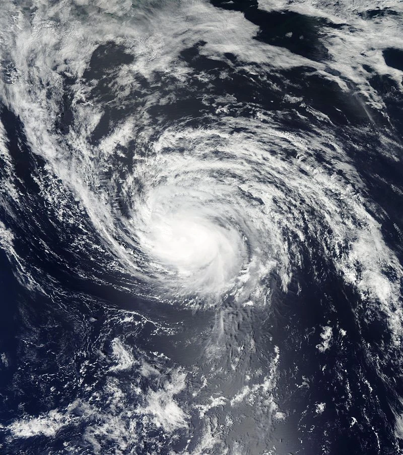
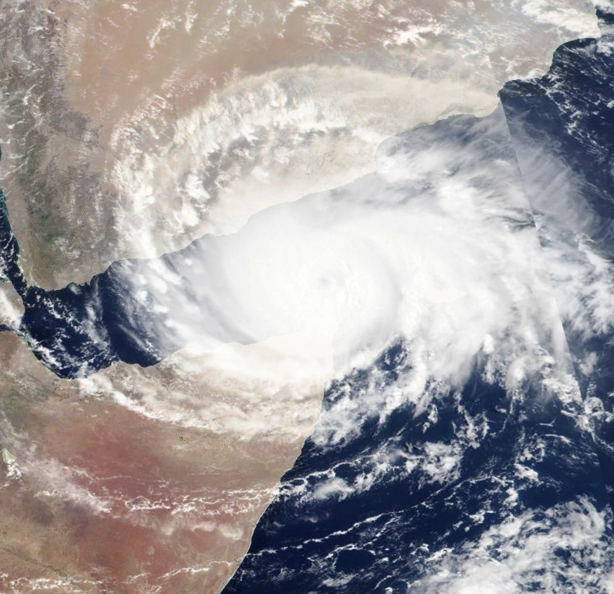
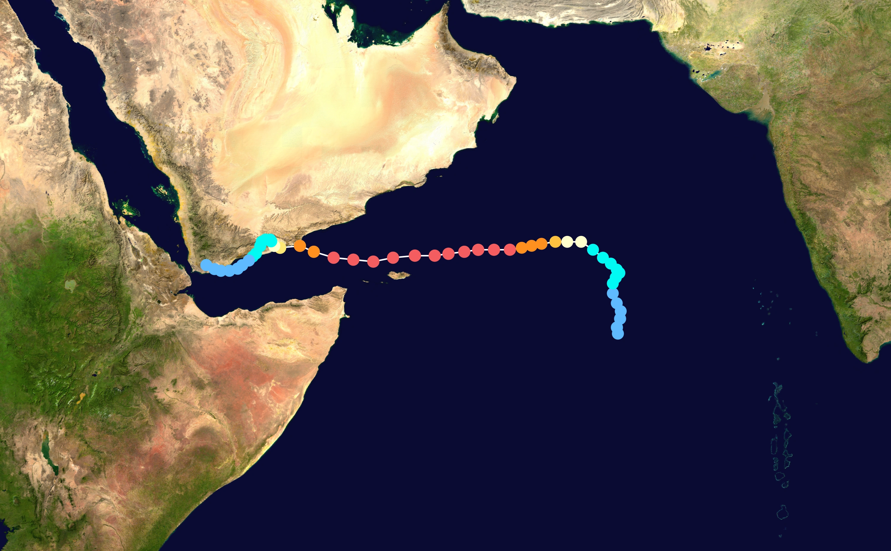
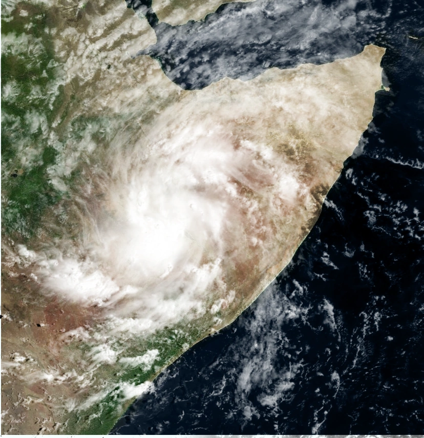
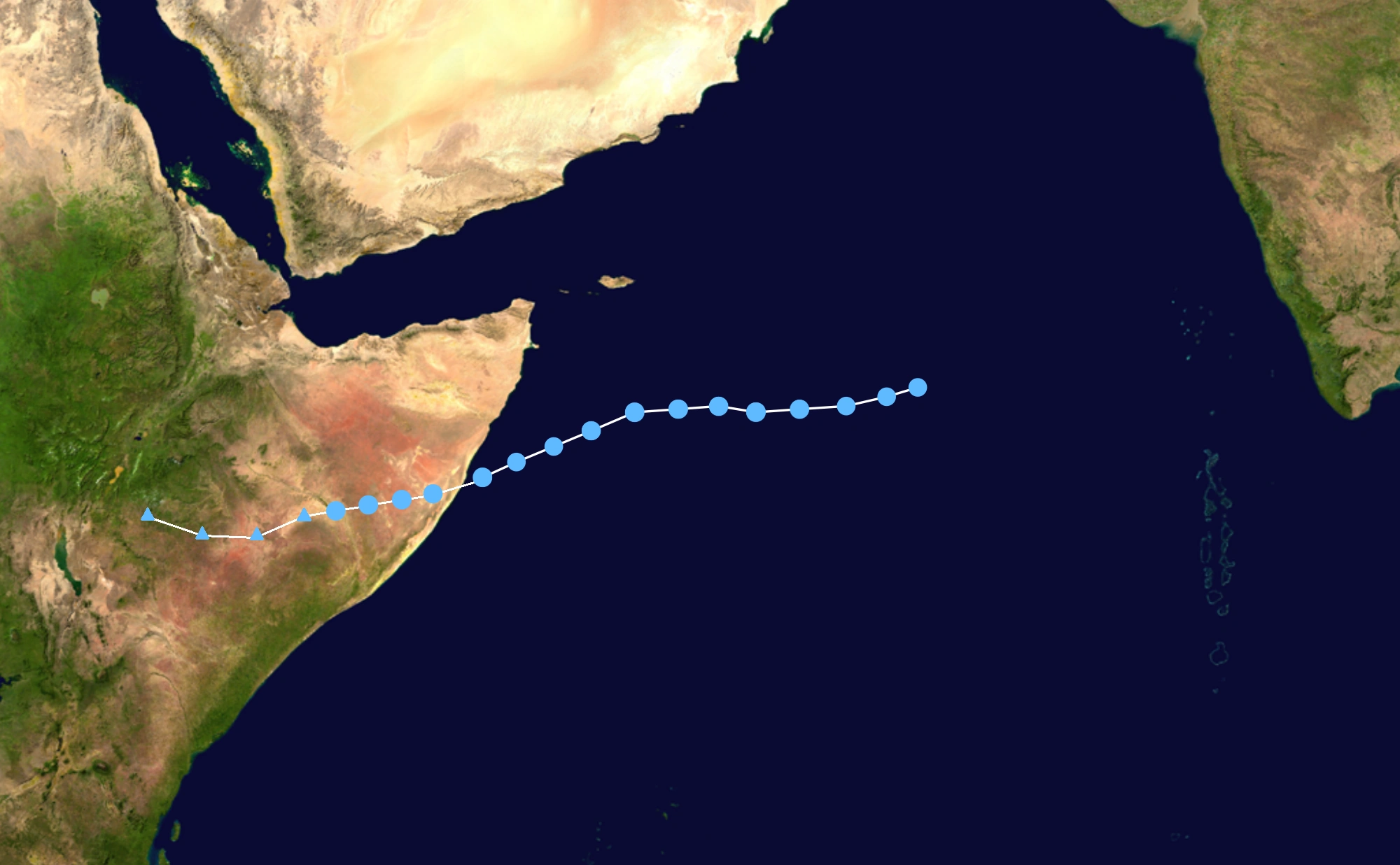
A trough developed along the northeast monsoon on 21 August 2048 off the southwest coast of India, consisting of a fragmented area of convection, or thunderstorms. The system was located within an environment of moderate wind shear, which prevented early development, although conditions were anticipated to become more favorable. On 22 August, the system developed a distinct low pressure area.The low gradually consolidated, and the circulation became better defined, amplified by decreasing wind shear and good outflow to the north and south. At 03:00 UTC on August 22, the India Meteorological Department (IMD) designated the system as a depression. Nine hours later, the agency upgraded it further to a deep depression, and the Joint Typhoon Warning Center (JTWC) classified the system as Tropical Cyclone 08A at 21:00 UTC.
Initially, the storm moved slowly to the north due to a ridge to the northeast, although the track shifted to the west due to another ridge to the northwest. With record warm water temperatures for the time of year, reaching 32 °C (90 °F), as well as favorable conditions related to the Madden–Julian oscillation, the system rapidly intensified beginning on August 24. At 00:00 UTC that day, the IMD upgraded the system to a cyclonic storm, giving it the name Ward. The storm developed well-defined rainbands as the structure consolidated more, with well established outflow to the north and south. An eye began developing, prompting the JTWC to upgrade it to the equivalence of a hurricane, with one-minute maximum sustained winds of 120 km/h (75 mph) six hours later. Meanwhile, the IMD upgraded Ward to a severe cyclonic storm at 09:00 UTC that day, and further to a very severe cyclonic storm at 18:00 UTC. By early on August 25, Ward had developed a well-defined eye 22 km (14 mi) wide, amplified by vigorous outflow and continued low wind shear. Based on satellite intensity estimates from the Dvorak technique, the JTWC assessed Ward as a high-end Category 4-equivalent cyclone on the Saffir–Simpson scale at 06:00 UTC with one-minute sustained winds of 240 km/h (150 mph); operationally it was held at 250 km/h (155 mph). Based on their estimate, Ward was one of the strongest cyclones on record in the Arabian Sea. Ward continued to intensify into a super cyclonic storm, or a Category 5-equivalent on the Saffir-Simpson scale, but halted after drier air began affecting the storm, causing the thunderstorms around the eye to diminish. However, the storm maintained much of its intensity due to strong outflow in all directions, especially to the northeast due to a tropical upper tropospheric trough over India despite increased wind shear.
After the cyclone bypassed Socotra, its convective core became better defined due to improved outflow.On August 27, Chapala entered the Gulf of Aden, becoming the strongest tropical cyclone on record in that region. At 12:00 UTC that day, the IMD downgraded the system to a very severe cyclonic storm. The structure became disorganized that day due to increased easterly wind shear and interaction with the Arabian Peninsula to the north,causing cooler and drier air to enter the circulation. Around this time, the storm began moving more to the west-northwest toward Yemen, rounding the southwestern periphery of a ridge.Between 11:00–12:00 UTC on August 28, the cyclone made landfall near Mukalla with winds of 160 km/h (105 mph). Ward quickly weakened near land, degenerating into a depression by 00:00 UTC on Augsut 30 and weakening into a remnant low pressure area three hours later in the south extreme of Yemen.
Ward caused widespread damage in mainland Yemen, Socotra and the Puntland region of Somalia.High winds, strong waves, and heavy rainfall affected the southern Yemen coast, with areas in the region receiving 610 mm (24 in) of rainfall over 48 hours, or 700% of the average yearly precipitation. The storm caused severe flooding along the coast, including in Mukalla, the nation's fifth largest city, where the seafront was destroyed by waves exceeding 9 m (30 ft). While passing north of Socotra, the storm brought heavy rainfall and high winds while inundating the northeastern part of the island. Large swells produced by Ward caused extensive coastal damage in eastern Puntland, with multiple structures, boats, and roads destroyed.The storm killed 18 people and caused US$2.3 billion in damages.
Extremely Severe Cyclonic Storm Aila
| Extremely severe cyclonic storm (IMD) | |
| Category 4 tropical cyclone (SSHWS) | |
  | |
| Duration | September 4 – September 10 |
|---|---|
| Peak intensity | 205 km/h (125 mph) (3-min) 938 hPa (mbar) |
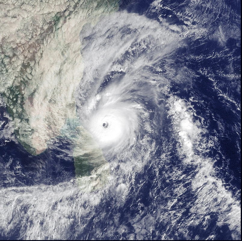
Under the influence of an upper-air cyclonic circulation,a low-pressure area formed over the Andaman Sea on September 3.It slowly consolidated and was upgraded to a depression by the India Meteorological Department . While over open waters, the depression continued to encounter a extremely favorable environment, and a tropical cyclone formation alert (TCFA) was issued by the Joint Typhoon Warning Center (JTWC), followed by IMD upgrading the storm into a deep depression.
In the early hours of September 6, the JTWC started issuing its advisories for the system as it recorded hurricane winds at the storm's centre,Aila continued to intensify the following day, and was upgraded to a severe cyclonic storm. Early on September 7, the JTWC classified the storm as a Category 3 cyclone after it formed a microwave eye feature and was located in an environment favorable for further intensification with low wind shear. The IMD upgraded Aila to a extremely severe cyclonic storm later the same day, and the JTWC further upgraded the storm to a Category 4 tropical cyclone.
On September 8, the storm stayed underwent rapid intensification and developed an eye at its center. In the following hours, the storm reached its peak intensity with a minimum central pressure of 938 mbar (28.05 inHg) and three-minute average windspeeds of 205 km/h (125 mph). Maintaining intensity, it made landfall over Visakhapatnam, Andhra Pradesh at noon of September 9, The maximum wind gust recorded by the High Wind Speed Recorder (HWSR) instrument of the Cyclone Warning Center in Visakhapatnam was 260 km/h (160 mph). Measured by the Doppler weather radar stationed in the city, the storm's eye was 66 km (41 mi) in diameter. The strength of the winds disrupted telecommunication lines and damaged the Doppler radar, inhibiting further observations.
Bringing extensive damage to the coastal districts of Andhra Pradesh,Aila gradually weakened as it curved northwards over land. The storm continued its weakening trend and was last noted as a well-marked low pressure area over east Uttar Pradesh, Unlike most BoB storms that dissipate quickly over land, Hudhud has been the only TC whose remnant ever reached as far north as the Himalayas.
Aila brought extensive damage to the coastal districts of Andhra Pradesh. At least 538 deaths were reported due to the storm and damage amounted to US$5 billion
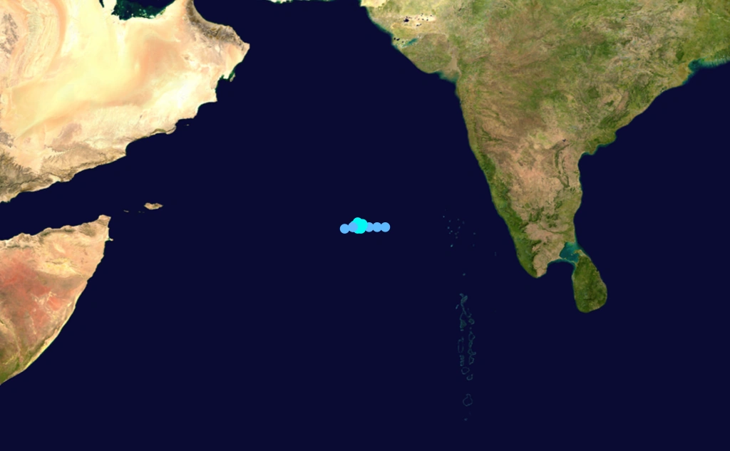
BOB 15
| Depression (IMD) | |
| Tropical storm (SSHWS) | |
  | |
| Duration | September 16 – September 20 |
|---|---|
| Peak intensity | 45 km/h (30 mph) (3-min) 994 hPa (mbar) |
In September 15, a low pressure area formed over the Arabian Sea. It slowly moved southwest and consolidated into Depression ARB 14 on September 16.The JTWC issued a Tropical Cyclone Formation Alert the same day, reporting that the depression was moving into an area favorable for further intensification.The next morning, the IMD upgraded the storm to a deep depression; the JTWC similarly upgraded the system to a tropical storm following reports of 65 km/h (40 mph) winds near the storm's center of circulation.Remaining stationary for nearly a day, the storm crossed the coast of Somalia early on September 18. The system rapidly deteriorated due to land interaction, and both the JTWC and the IMD issued their final warnings on the system later on September 20 when the storm cross Ethiopia. ARB 12 made landfall in the south Puntland region.Around 2 fatalities were reported in the wake of the storm, as well as livestock casualties and damaged infrastructure. Much of the damage was averted by an early administrative response overseen by the Puntland Disaster Management and Rescue committee, which coordinated relief efforts by the Puntland Maritime Police Force, governmental rescue teams, and the Puntland Highway Authority.
BOB 16
| Depression (IMD) | |
| Tropical depression (SSHWS) | |
  | |
| Duration | September 18 – September 20 |
|---|---|
| Peak intensity | 35 km/h (25 mph) (3-min) 1002 hPa (mbar) |
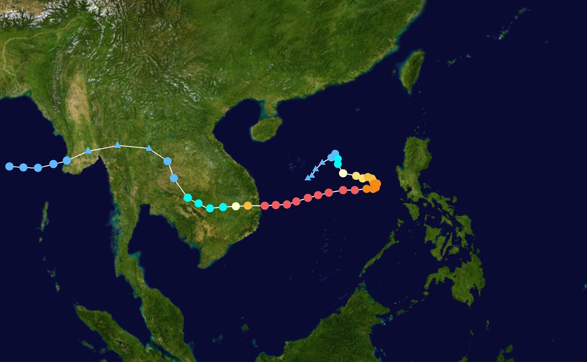
Super Typhoon Linda weakened further over the mountainous terrain of the Malay Peninsula, and the storm emerged into the Andaman Sea with winds of 25 mph (35 km/h). This made Linda the first tropical cyclone since Tropical Storm Forrest in 1992 to cross from the western Pacific Ocean into the Indian Ocean. Additionally, upon reaching the Indian Ocean, the India Meteorological Department (IMD) classified the storm as depression BOB 16,it gradually weakened for two days. On September 20, BOB 16 dissipated about 375 miles (600 km) southwest of Yangon, Burma.That day, the IMD also terminated advisories.
Season effects
This is a table of all the storms that formed in the 2048 Indian cyclone season. It includes their duration, names, affected areas, damages, and death totals. Deaths in parentheses are additional and indirect (an example of an indirect death would be a traffic accident), but were still related to that storm. Damage and deaths include totals while the storm was extratropical, a wave, or a low, and all the damage figures are in 2018 USD.
| Saffir–Simpson hurricane wind scale | ||||||
| TD | TS | C1 | C2 | C3 | C4 | C5 |
| Storm name |
Dates active | Storm category at peak intensity |
Max 1-min wind mph (km/h) |
Min. press. (mbar) |
Areas affected | Damage (USD) |
Deaths | |||
|---|---|---|---|---|---|---|---|---|---|---|
| Ogni | May 17 – 20 | Tropical storm | 50 (85) | 990 | Iran,Oman | 100 million | 8 | |||
| Agni | June 1 – 6 | Category 3 hurricane | 100 (155) | 958 | Tailand,Vietnam,
Laos |
Unknow | 24 | |||
| Hibaru | June 14 – 18 | Tropical storm | 50 (85) | 999 | none | none | none | |||
| Pyarr | June 28 July – 3 | Category 3 hurricane | 105 (165) | 948 | Bangladesh
India |
12 Billion | 721 | |||
| Baaz | July 1 – 6 | Category 4 hurricane | 125 (205) | 932 | Oman
UEA Iran |
Unknow | 3 | |||
| Florence | July 12 – 20 | Category 3 hurricane | 105 (165) | 958 | India
Sri Lanka |
2,8 Billion | unknow | |||
| Mala | July 19 – 23 | Tropical storm | 40 (65) | 994 | Sri Lanka | None | None | |||
| Nisha | July 26 August – 8 | Category 5 hurricane | 140 (220) | 902 | India
Sri Lanka |
$36.3 billion | 1352 (15) | |||
| Bijli | August 4 – 11 | Category 5 hurricane | 155 (250) | 898 | Tailand | 15 Billion | 245 | |||
| Land Storm 09 | August 11 – 15 | Tropical storm | 50 (85) | 988 | India
Pakistan |
30 Billion | Above
2000 | |||
| Pyan | August 13 – 21 | Category 1 hurricane | 75 (125) | 978 | Malasia
Tailand Singapore Philipines |
1 Billion | 14 | |||
| Ward | August 22 – 30 | Category 5 hurricane | 150 (240) | 912 | Yemen
Somalia Eritrea |
$2.3 billion | 18 | |||
| Aila | September 4 – 10 | Category 4 hurricane | 125 (205) | 938 | India | 5 billion | 538 | |||
| Bob 15 | September 16 – 20 | Tropical storm | 30 (45) | 994 | Somalia
Ethiopia |
55 million | 2 | |||
| Bob 16 | September 18 – 20 | Tropical storm | 25 (35) | 1002 | Thailand | Unknow | none | |||
| Season aggregates | ||||||||||
| 15 systems | May 17 – September 20 |
155 (250) | 898 | $40.8 billion | 528 | |||||
See also
- 2048 Atlantic hurricane season
- 2048 Pacific hurricane season
- 2048 Pacific typhoon season
- South-West Indian Ocean cyclone seasons: 2047–48, 2048–49
- Australian region cyclone seasons: 2047–48, 2048–49
- South Pacific cyclone seasons: 2047–48, 2048–49
External links
- ↑ 1.0 1.1 Saunders, Mark (May 5, 2017). Extended Range Forecast for Northwest Pacific Typhoon Activity in 2017. Tropical Storm Risk Consortium. Retrieved on May 5, 2017.
- ↑ Saunders, Mark (July 6, 2048). July Forecast Forecast Update for Indian Cyclone Activity in 2017. Tropical Storm Risk Consortium. Retrieved on July 6, 2048.
- ↑ Saunders, Mark (August 7, 2048). August Forecast Forecast Update for Indian Cyclone Activity in 2048. Tropical Storm Risk Consortium. Retrieved on August 8, 2048.
- ↑ 4.0 4.1 Malano, Vicente B (January 20, 2048). January — June 2017. Philippine Atmospheric Geophysical and Astronomical Services Administration. Archived from the original on January 29, 2048. Retrieved on January 29, 2048.
- ↑ Template:Cite press release
- ↑ 6.0 6.1 Template:CitationMalano, Vicente B (July 6, 2017). July — December 2017. Philippine Atmospheric Geophysical and Astronomical Services Administration.