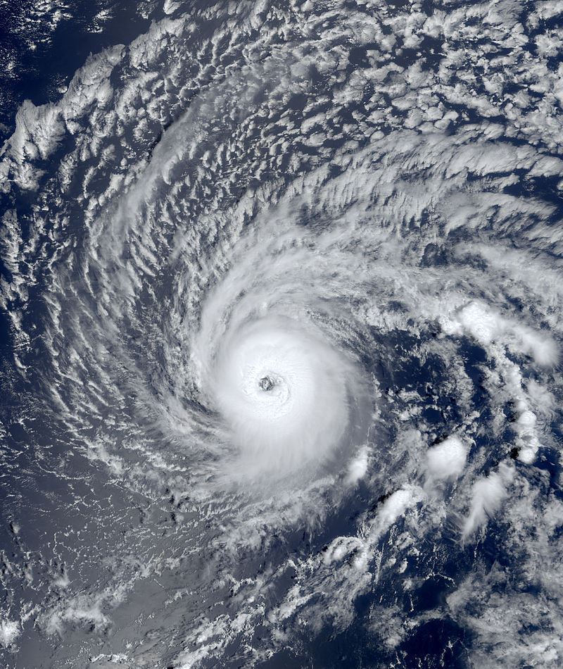
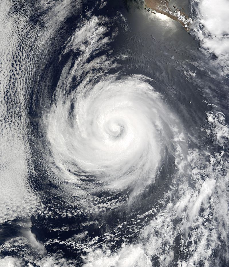
The 2035 Pacific hurricane season was the first season to have a tropical cyclone form during the month of February. This season was slightly above-average, that produced 17 named storms, 9 hurricanes, and 3 major hurricanes. The strongest storm, Kay, was a strong Category 5 storm. Kay peaked with winds of 180 mph, and attaining a minimum pressure of 897. This made Kay the second-strongest storm in the North Pacific basin, behind Patricia of 2015.
As mentioned before, the season started very early, 3 months before the season. Tropical Depression One formed on February 3, later becoming Tropical Storm Agatha the next day. Agatha did not affect any land. The season started to become active during the first half, but became less active in the second half of the season. The most active season was July, with 4 storms forming in it. The month September featured the strongest storm, Kay.
Seasonal forecasts[]
work in progress
Seasonal Summary[]
As the beginning of the year was beginning, a tropical wave formed on Groundhog Day on 2035. The tropical wave was forecast to not develop. However, the low developed into the first February tropical cyclone in the modern era. The tropical depression later strengthened into Tropical Storm Agatha. Agatha was a relatively weak tropical cyclone, lasting for only less than 60 hours. Agatha dissipated slightly more than a day later.
Storms[]
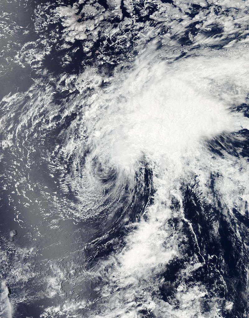
Tropical Storm Agatha[]
| Tropical storm (SSHWS) | |
  | |
| Duration | February 3 – February 5 |
|---|---|
| Peak intensity | 40 mph (65 km/h) (1-min) 1009 mbar (hPa) |
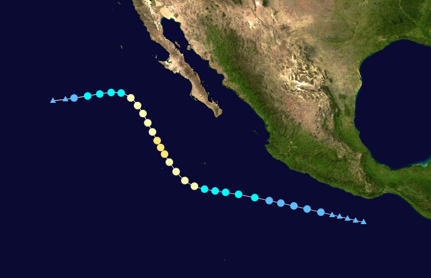
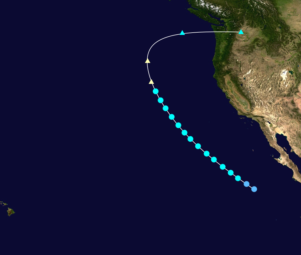
A non-tropical area of low-pressure merged off the coast of Mexico. The low-pressure area organized, and was unexpectedly monitored by the NHC. The models forecast this low to not develop. However, the system continued to develop. At 23:00 UTC, the National Hurricane Center upgraded the low into a tropical depression. Thus, this formation was the first time that a tropical system developed in the month of February. The tropical depression was designated as One. But, some model agencies labeled his system as 01.E, not TD One. The tropical depression was predicted to dissipate, but unexpectedly strengthened into Tropical Storm Agatha one day later. Agatha was the first named storm in the month of February in the modern era. Agatha stayed as a tropical storm for 12 hours, before weakening. TD Agatha slowly deteriorated as it curved NNW. Agatha opened up into a wave on 00:00 UTC on February 6.
Hurricane Blas[]
| Category 1 hurricane (SSHWS) | |
  | |
| Duration | May 17 – May 26 |
|---|---|
| Peak intensity | 80 mph (130 km/h) (1-min) 979 mbar (hPa) |
On May 12, a tropical wave formed near Mexico, trekking westwards. The tropical wave slowly became defined, and around 13:00 UTC on May 15, the National Hurricane Center began to monitor this system. Due to warm ocean waters, the chances given for development were relatively high. Therefore, the low slowly organized, while slowly gaining convection. Eventually, on May 17, the National Hurricane Center upgraded the low, which produced gale-force winds, into Tropical Storm Blas, skipping the tropical depression category. Blas remained a weak tropical storm, due to wind-shear. Blas weakened into a tropical depression, only to re-strengthen several hours later. Blas continued to strengthen, and then became the first hurricane of the season, with winds of 80 mph, and attaining a minimum pressure of 979 mbar. Blas then weakened again, and then began to slowly weaken. Blas then entered northern latitudes, and then weakened into a tropical depression. Blas then dissipated into a remnant low on May 26.
Hurricane Celia[]
| Category 2 hurricane (SSHWS) | |
  | |
| Duration | May 28 – June 4 |
|---|---|
| Peak intensity | 105 mph (165 km/h) (1-min) 988 mbar (hPa) |
Early on May 26, an area of low-pressure formed near Mexico. The low-pressure system trekked north-west, encountering favorable conditions for further developments. Therefore, the National Hurricane Center began to monitor this system. The low gained sufficient amount of convection, and organization increased. Eventually, in the afternoon on May 28, the National Hurricane Center upgraded the tropical low to Tropical Depression Three. Three remained as a tropical depression for a day, before strengthening into Tropical Storm Celia. Forecast models predicted Celia to remain a relatively weak storm. Celia started to strengthen, and 30 hours later, Celia was upgraded to a hurricane, the second of the season. Celia curved significantly north, but remained a northwest-trekking storm. Celia continued to strengthen, and for around a day, became a Category Two hurricane, the first of the season. Celia weakened due to wind-shear and cool ocean-temperatures. Celia continued to weaken, and then became a tropical storm. Celia then trekked southwest, slowly deteriorating. Early on June 4, Celia degenerated into a remnant low.
Tropical Storm Darby[]
| Tropical storm (SSHWS) | |
  | |
| Duration | June 9 – June 16 |
|---|---|
| Peak intensity | 70 mph (115 km/h) (1-min) 990 mbar (hPa) |
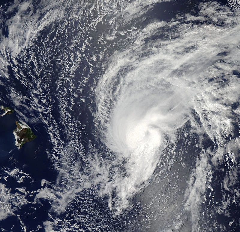
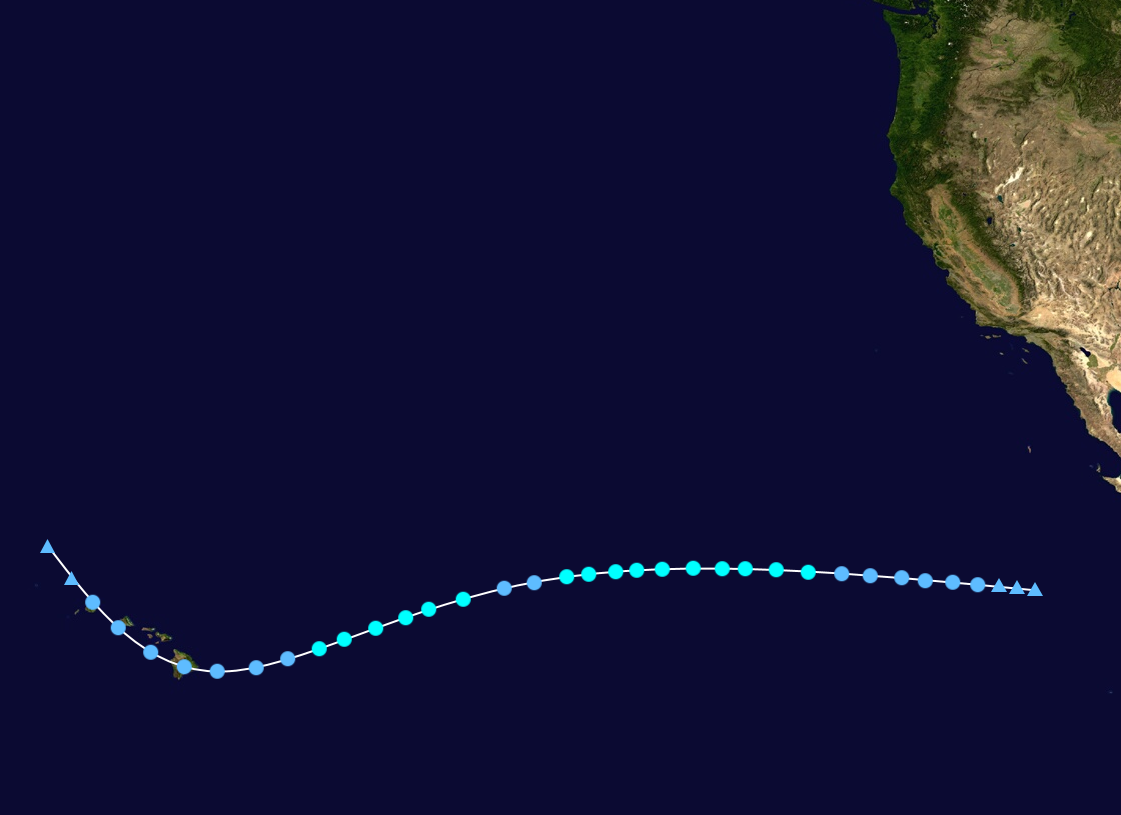
On June 5, a tropical wave formed off the coast of Mexico, and tracked westwards. The low became very unorganized. However, the low re-organized, and on June 8, the National Hurricane Center started to monitor this system. The system was noted to have the potential to become a tropical cyclone. This system continued to develop, and on June 9, the system was upgraded into Tropical Depression Four. Models had this system to peak as a relatively strong storm. The system failed at first to strengthen into a tropical storm due to its encounter to wind-shear. Four later strengthened into Tropical Storm Darby due to a reconnaissance plane finding winds of 42 mph. Darby rapidly intensified, peaking at 70 mph. An eye development briefly occurred, but did not signal the upgrade of Darby, due to a slight decrease in storm convection. Darby slowly became disorganized, and then weakened to a tropical depression. But this was only to last for a short time. Tropical Depression Darby later re-strengthened into Tropical Storm Darby. Darby was in a south-west track, seeming to go south of Hawaii. However, Darby weakened into a tropical depression, curving back northwest, posing a threat to Hawaii. Tropical Storm Watches were issued for the entire state of Hawaii, as there was a possibility that Darby could re-intensify again. This was not the case, and Darby, as a tropical depression, made landfall in the Big Island of Hawaii. Darby rapidly disorganized, and became a remnant low early on June 16.
Tropical Storm Estelle[]
| Tropical storm (SSHWS) | |
  | |
| Duration | June 19 – June 23 |
|---|---|
| Peak intensity | 70 mph (110 km/h) (1-min) 988 mbar (hPa) |