Disclaimer: The content on this wiki is fictional and NOT a resource for real tropical cyclones. NONE of this wiki's content should be taken as a real indication of inclement weather.
The 2028 Atlantic Hurricane Season was a hyper-active season. The season featured 23 total named systems, 11 hurricanes and 6 major hurricanes. The season was the second season to ever use all of the names on the naming list and have to use the Greek Names, the other being the 2005 Atlantic hurricane season. Overall, the season was the most destructive in terms of USD since the Hyperactive 2017 Atlantic hurricane season.
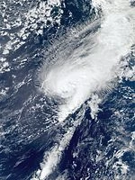
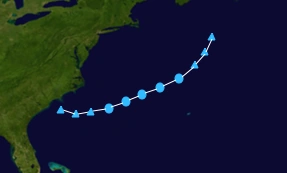
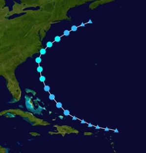
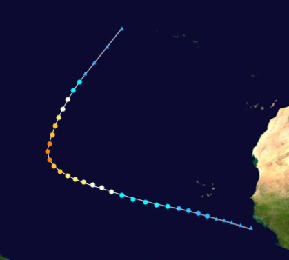
On February 5, the NHC started to monitor a extratropical system, with potential for development. On the 8th of the month a tropical depression formed, the first of the year and the earliest tropical cyclone formation in the Atlantic since Hurricane Alex of 2016. Tropical depression one strengthened into Alex just hours after becoming tropical depression one and has max sustained winds of 40 mph. Alex continued on its west to north westward track toward Bermuda, strenthening while doing so. Alex would reach peak Intensity of 60 mph on February 10, while still on its north westward track into a more unfavorable environment. Alex started to weaken once it started to move into cooler waters. Alex also started to weaken once it made landfall in Bermuda on February 11. Alex became post tropical on February 12. Alex also weakened to 35 mph just a day later and the remnants of Alex finally weakened and dissipated on February 15.
Alex was known to cause under $20,000 (2028 USD) in damage on the island of Bermuda, and was not blamed for any loss of life.
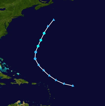
On May 20, the NHC started to monitor an area of interest for potential tropical development. The tropical wave gradually got more organized and on May 23 just 125 miles southwest of Florida, tropical depression two formed. Two, slowly strengthened in the Gulf of Mexico and became Tropical storm Bonnie several hours later and had sustained wind of 40 mph. Bonnie would continue to strengthen before landfall and would reach 45 MPH on May 24 at 8 AM. A Tropical Storm Warning was issued for the West Coast of Florida just hours later. Also a storm surge warning was also issued with potential storm surge being predicted to reach at least 4–5 feet. Bonnie reached a peak intensity of 50 MPH on May 24 at the 5 PM advisory and started to accelerate toward Florida at 15 mph and continued to speed up. Bonnie then made landfall in Florida on May 24 at 11 PM causing minimal damage as it did and would immediately weaken to a tropical depression. Bonnie weakened to a remnant low on May 25 in the afternoon after making landfall. Bonnie's remnants would take a track similar to Colin of 2016 and would continue OTS as a post tropical cyclone.
Bonnie was blamed for $25,000 US Dollars in the Florida panhandle and overall was blamed for 3 deaths in Florida and also 15 people went missing and all of them are presumed dead. Maximum storm surge associated with Bonnie was around 6 feet reported in some areas. Also over 21 inches of rain fell in some isolated areas, but most areas received around 7-10 inches of rain from Bonnie.
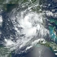
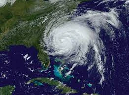
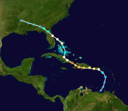
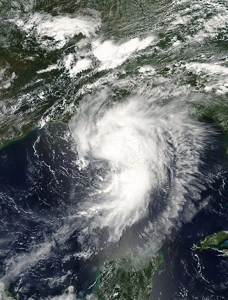
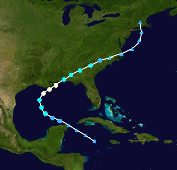
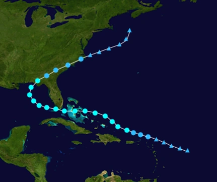
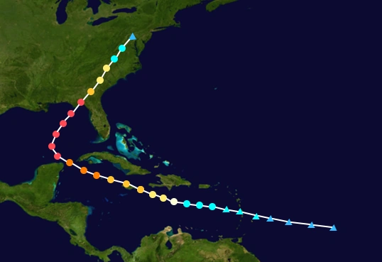
On June 24 the NHC started monitoring a tropical wave located in the carribbean sea for tropical cyclone development, and because it was disorganized the NHC gave it a low chance of development within 5 days. The wave started to fire weak convection, but gradually the convection got deeper and the NHC gave it a high chance of development within 2 days. On June 28 Tropical Depression three formed and would quickly strengthen into a 40 mph tropical storm and received the name Colin. Colin started to rapidly strengthen as it moved northwest toward costa Rica and passed just to the south of Dominica. Colin caused minor damage in Dominica, most of the damage came from downed trees that landed on houses. As Colin passed by Dominica it was strengthening and has winds of 65 mph. On June 30, the NHC declared Colin a category 1 hurricane with 75 mph winds and predicted Colin to continue to strengthen and peak at around 110-115 mph. Colin contiued to strengthen even though some land interaction stopped Colin from rapidly intensifying, but as it moved past Dominica it started to rapidly strengthen and became a major hurricane (the first of the season) with 115 mph winds. The NHC started to release hurricane warnings and watches for several different countries in Colin's path. Colin would start to take a more northward track toward the Bahamas and Florida and would start to moved right toward Cuba and would continue to strengthen. On July 2, Colin strengthened into a category 4 hurricane and didn't stop there, continuing to strengthen as it approached Cuba. Colin finally reached a peak Intesnity the same day at 140 mph and would retain this strength as it continued to move foward toward Cuba. On the night of July 2, Colin made landfall in Cuba at peak intensity as a category 4 major hurricane.
Colin caused major flooding problems in Cuba as it made direct landfall on the island nation. Over 35" fell in some regions of Cuba and many power outages were also reported. Colin immediately started to weaken after it made landfall in Cuba and would weaken below major hurricane strength on the morning of July 3. Many people drowned from major flooding problems in populated areas. Also very intense winds downed may trees and power lines killing several people as well. Overall damage from Cuba was accessed to be over $1 billion (2028 US Dollars) and Colin was also blamed for over 135 deaths from just the cuba. After landfall in Cuba, Colin exited the coast and moved back into the Atlantic Ocean and started to restrengthen after weakening into a tropical storm. The NHC issued a hurricane watch for Florida as Colin had the potential to strengthen back into a hurricane before an anticipated 2nd landfall in Florida and the surrounding areas. Colin did restrengthen back into a category 1 hurricane on July 4 and the hurricane watch that the NHC issued for Florida was changed into a hurricane warning as Colin neared Florida. Colin started to accelerate in speed as it neared Florida to over 12 mph and strengthened to its secondary peak of 90 mph. Colin made landfall in Florida on July 4. Many people that were visiting Florida for July 4 weekend were caught up in Hurricane Colin as it made landfall as a strong category 1 hurricane. In Florida (just like Cuba) flooding was the worst issue as locally rains peaked at over 13", and many people drowned due to the floods. Colin also brought wind gusts of over 105 mph that leveled some buildings and downed numerous trees that damaged many homes.
Colin started to weaken again as it moved completely over land and became a tropical storm on the night of July 4 and on the morning of July 5, Colin had weakened so much that the NHC released their final advisory on post tropical cyclone Colin. Overall in Florida, Colin was known to cause about $450 million (2028 US Dollars) and was blamed for over 25 deaths. Colin's remnants continued on as post tropical and affected numerous states causing some minor flooding problems in Georgia, mississippi, and Alabama and also surrounding states. In total Colin was known to cause over $1.8 billion in damage across its entire lifetime and was blamed for over 250 deaths. Colin's remnants finally dissipated over Texas on July 8. The WMO got together and decided to retire the name Colin from the naming lists due to the extreme amount of damage and deaths it caused. It was replaced by the name Collin and will be used in the 2034 Atlantic hurricane season.
On June 30, while Colin was active another tropical wave exited off the coast of Africa and struggled to develop due to the cool sea surface temperatures and abnormally high wind shear in the area. The wave continued to Struggle until it turned a little more northwest and immediately started to fire up deep convection and on the morning of July 2, tropical depression four formed. Four continued to strengthened and started to turn just straight westward toward South Carolina and became tropical storm Danielle with just 40 mph winds. The NHC started to send recon flights to danielle to find if it was any stronger than predicted. The first recon flight into Danielle found sustained winds of 50 mph and a low pressure of 998 mb. Numerous recon flights were sent into the system and continued to find stronger winds in the system. Danielle would finally reach a peak of 70 mph, just over 150 miles away from the coast of south carolina. Danielle started to weaken as it moved toward the coast of the carolina's. Danielle weakened into a tropical depression before making landfall in South Carolina and immediately would dissipate after it made landfall on July 7. The remnants of Danielle however held together for just a little longer and caused flooding in many areas, but the flooding was minor and no lives were lost. Damage was estimated to be under $500,000 (2028 US Dollars) and the name Danielle was not retired, so it will be used again for 2034.
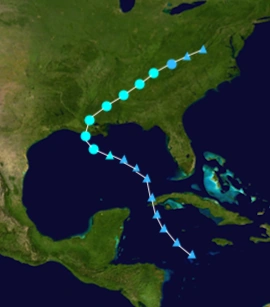
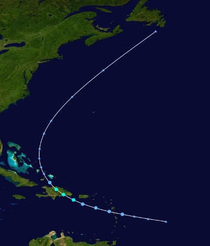
The NHC started to monitor a tropical disturbance in the Caribbean on July 3. The disturbance started to move to the northwest and would not gain any strength. The system would slowly organize as it moved very slowly across the Caribbean sea to the northwest. On July 5, the hurricane hunters found the system was getting more organized and was producing winds of 34-35 mph, but they also found it lacked a circulation to it. The next day however, another hurricane hunters flight found that overnight the system formed a Circulation and was still also producing winds of 35 mph, prompting the upgrade on July 6, to Tropical Depression Five. Numerous hurricane hunters were sent out to the system each day, finding that they system had strengthened a little and was also a little more organized. On the night of July 7, Tropical Depression Five strengthened into Tropical Storm Earl, because of a recon flight finding 40-45 mph winds in the system. Earl continued to the northwest at 8 mph, but would start to turn more northward on July 8 and into July 9, Earl has started to move to the northeast. Earl continued to strengthen, prompting to release Tropical Storm watches in Louisiana-Florida, along with a hurricane watch, for a potential hurricane landfall. Earl continued to strengthen and later on July 9, a recon flight found hurricane winds of 75 mph in Earl, prompting the NHC to change the tropical storm warnings, to hurricane warnings. Earl continued its movement to the Northeast and would reach a peak intensity of 85 mph and would close in on a landfall on the US. On July 10, Hurricane Earl made official landfall in Mississippi and immediately started to weaken. Earl became a weak tropical storm later on July 10, but would cause a lot of damage across the path it took. On July 11, Earl weakened into a tropical depression, and on the next advisory, the NHC declared Earl was a remnant low. The remnants of Earl remained very weak once entering the Atlantic again. Earl's remnants turned to the north on July 13 and would make a second landfall close to New York City.
Damage from Earl was lower than expected in total being only around $350 million (2028 USD), but Earl would prove to be very fatal, because of the many tornado outbreaks associated with Earl. 55 people died in total, (52 Direct, 3 Indirect). The name Earl was retired in the Spring of 2029 and was replaced with Ethan.
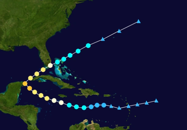
On July 11, a tropical wave exited the coast of Africa, and the NHC started to monitor it for potential development. The wave would gradually get more organized and on July 13, the NHC declared that Tropical Depression Six had formed. Six would head generally north to the northwest at a slow pace of 4 mph. Six would would become Tropical Storm Fiona on the night of July 13 with 40 mph winds. Fiona was forecast to become a robust tropical storm, but struggle due to unfavorable conditions, however Fiona did not seem to be affected by these conditions as it continued to strengthen. Fiona became 70 mph on July 15, and was then forecast by the NHC to become a category 2, with the possibilty of becoming a major hurricane as well. Fiona became the third hurricane of the season on the morning of July 16, and would keep strengthening, seemingly being unaffected by dry air and cooler Sea Surface Temperatures. Fiona became a category 2 hurricane not long after it became a hurricane, with 95 mph winds, and started to turn to the northeast instead of continuing in the northwest pattern as the NHC predicted. Fiona reached a peak intensity soon after of 105 mph and a pressure of 966 mb. Fiona finally started to weaken due to the very unfavorable conditions and became a category 1 hurricane again and kept weakening after this. On July 17, Fiona started to lose convection and weakened below hurricane status, back to tropical storm intensity with 65 mph. A little later Fiona lost all it's convection and by their next advisory the NHC released its final advisory on Fiona, but would emphasize that the Azores would be hit by Fiona's remnants which could be pack strong TS winds when it did make landfall.
The Remnants of Fiona would continue its track northward toward the Azores, and would make landfall their on July 20, packing 50-60 mph winds, with gust as high as 80 mph. Damage on the Azores was moderate and lower than initially expected, but 7 people did die in the remnants of the hurricane. Flooding was the main issue though in the remnants of Fiona, with as much as 13 inches falling in some isolated areas. Overall though, Fiona was only known to cause $1.5 million (2028 USD) and was blamed for 7 deaths (all direct).
On July 22, the NHC noted the possibility of development in the Atlantic from an extratropical cyclone over the carolinas. The system moved off the coast, and moved into warmer waters which would allow for organization and strengthening. The system would organize enough and become a tropical depression on July 24. Seven was originally forecast to become a tropical storm and be named Gaston, but it would refuse to strengthen and would remain at 35 mph. On July 26, the depression finally weakened to 30 mph, and started to collapse in structure. That night, in their 11 pm advisory the NHC noted that Seven would probably become a post-tropical system in the next day or so. However Seven started to fire weak convection again, preventing the NHC from issuing a last advisory on it. Shortly after though, Tropical Depression Seven lost all its convection and would become post-tropical. Seven was not blamed for any damage nor loss of life.
On July 26, the NHC started to monitor a strong tropical wave moving west, northwestward at 20 mph. The system gradually got more organized and on July 28 the NHC named it Potential Tropical Cyclone Eight and said it had 35 mph winds. The next day a Recon Mission found that the system had a closed circulation and 40 mph winds, so on July 29, the NHC deemed the system Tropical Storm Gaston and noted the possibility of a US Hurricane Landfall. Gaston continued to slowly strengthen and reached 50 mph early on July 31. Most models started to predict a movement back to the east toward Florida after Gaston would enter the Gulf of Mexico. The NHC issued hurricane watches for the western coast of Florida and also tropical storm warnings for the same areas and for the coastal areas of Georgia and Alabama. On August 2, Gaston reached its peak intensity of 60 mph and 1000 mb and was making its turn to the east, northeastward. Gaston would not strengthen and become a hurricane as it sped up and hit the US quicker than most models had predicted it to. Early on August 3, the center of Gaston made landfall in Georgia and the surrounding areas. Gaston quickly weakened and on August 4, Gaston became a remnant low and continued to the northeast hitting several other states. The remnants of Gaston dissipated after heading north over cooler waters.
Overall, Gaston caused about $80 million dollars in damage (2028 USD) and was blamed for 14 fatalities. Heavy rain from the system caused major flooding problems in many states. The worst damage was in Georgia, where the system made landfall, as heavy wind and rainfall, flooded and destroyed many buildings.
On July 28, the NHC started to monitor a tropical wave located 125 miles east of the Leeward Islands for potential development. The system never got any more organized until later, when it was in the Western Caribbean Sea. The environment the system was in was hostile for development due to several ULL located around the system. The system would continue to move north and would make its way into the Gulf of Mexico, where conditions were still very hostile for development. The NHC said on July 31, that the system was very unlikely to form due to the very hostile environment, and that the system would probably die out in the Gulf of Mexico the next day or so. However, the system defied expectations and became more organized. A Recon flight investigated the system late on August 1, and found sustained winds of 40 mph, but also noted the system had no center of circulation, so it was not declared a tropical cyclone yet. The next day however, in the early morning hours a recon flight confirmed a Center in the system and still also found 40 mph winds, which prompted the NHC to release its first advisory on Tropical Storm Hermine and also issue tropical storm watches and warnings for the Gulf Coast. Hermine would struggle to intensify initially but it briefly hit a more favorable spot and would strengthen to its peak intensity of 45 mph and 1001 mb, which was measured by a recon flight. Hermine would make landfall on August 3, at its peak intensity of 45 mph. Hermine stayed at this intensity for 12 hours over land before finally weakening. Hermine started to weaken, but it continued to havoc to the places it affected, Hermine would become a Tropical Depression on August 5 and would finally dissipate 6 hours later, while over Tennessee. The remnants of Hermine continued northeast, before being absorbed by a larger system.
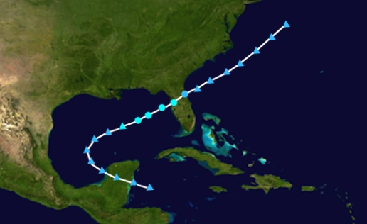
On August 5, a tropical wave moved off the coast of Africa and slowly moved west. The NHC noted the possibility for tropical cyclone genesis and gave it a low chance of formation on August 7. The wave took an Unusual southwest turn and continued like this for a short period of time. The system formed into Tropical Depression Ten on August 10, and the NHC noted the possibility of a hurricane potentially hitting some areas hard. The next day the system strengthened into Tropical Storm Ian with 40 mph winds. The possibility of a major hurricane was much higher than usual, due to the unusually low amount of wind shear in the forecast track and the marginally warm water temps. Ian continued to strengthen and became a hurricane on August 12 while moving west, northwest, with peak winds observed by a recon flight of 80 mph and a minimum central pressure of 979. Ian started to rapidly intensify at this point quickly reaching category 2 strength 12 hours later. Ian would Continue to strengthen and became a major, late on August 14, with peak winds of 115 mph. Ian began to affect
On August 25, a tropical wave moved off the coast of Africa and began to move quickly to the west. The NHC noted the possibility of tropical development later into the next week. The wave was very unorganized for the next couple of days, only showing slight signs of developing. The wave entered the Caribbean Sea on August 29, and would start to fire up, strong convection and start to consolidate itself. The NHC started to issue advisories on Tropical Storm Karl on August 30.
On September 15, a tropical wave exited the coast of Africa, and began to move quickly to the west. The NHC noted that the wave could potentially become a tropical system once it moved past the unfavorable environment currently occupying most of the MDR. It took a couple of day but the system finally moved past this unfavorable environment and began to consolidate itself. The system dubbed "Invest 94L"
On October 26, the NHC started to monitor a non-tropical low in the Gulf of Mexico for potential development. The low began to acquire tropical characteristics and on October 28, Tropical Depression Twenty formed. The system was forecast to become a weak tropical storm before it made landfall near the border of Texas and Mexico. On October 29, Twenty strengthened into Tropical Storm Shary
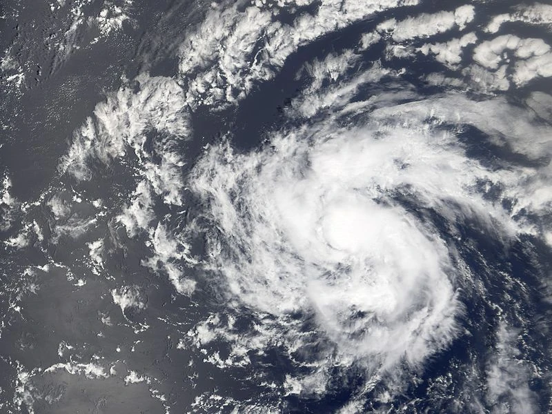
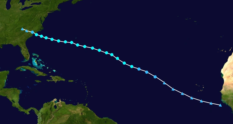
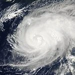
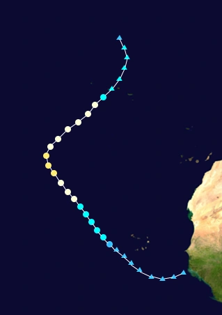
On November 10, a vigorous tropical wave exited the coast of Africa. The NHC started to monitor the wave for potential tropical cyclone formation. The wave continued to get more organized and on Late on November 11, the NHC started to issue advisories on Potential Tropical Cyclone Twenty-One because, of the close proximity to the Cabo Verde Islands. The NHC issued tropical storm watches for many of the islands and even some warnings for a few of them. The next morning the NHC named the system Tropical Storm Tobias with 40 mph winds. The system at first was predicted to go over or just to the south of the Islands, however the system went farther south than expected and has less of an impact on the Islands than expected. However, rough surf and an increased chance of rip currents remained as problems for the Islands. As Tobias moved away from the islands and into a mor favorable environment, the system stalled out in intensity for a day or so unexpectedly. Tobias would begin to strengthen again later that day and into the next day as well. Tobias started to develop a visible eye as seen on satellite, however ASCAT passes were only showing max winds of 60 mph however on November 15, Tobias reached Hurricane strength with 75 mph winds as the NHC went with ADT estimates and other reliable sources as well. Once Tobias reached hurricane strength, it would rapidly intensify the next day into a Category 3 Major Hurricane and the next day it was a Category 4 Hurricane. Tobias reached a peak intensity of 150 mph on November 18 with a low pressure of 935 mb.Tobias would start to weaken as it turned to the NNE and into cooler waters. The system would begin to undergo Post-tropical transition on November 21 and on November 23, The NHC declared that Tobias was extratropical. The remnants of Tobias went onto affect the Azores and also caused rough surf in the surrounding areas as well.