The 2017 Atlantic hurricane season featured similar activity to that of the previous season. It was above average, with 17 total cyclones, 16 named storms, 8 hurricanes, and 3 major hurricanes. The season officially ran from June 1 to November 30, however, as was demonstrated by the formation of Philippe on December 9, storms can form at any time of year. It was the costliest season since 2012; three storms accounted for most of the damage done: Tropical Storm Don, Hurricane Jose, and Tropical Depression Fifteen, totaling at $38.967 billion (2017 USD) alone. The rest was created by all the other storms, primarily Hurricane Emily. Most of the deaths came from Haiti as a result of Don. The nation is very intolerant to even minor disasters and was still recovering from Hurricane Matthew. The amount of activity was greatly aided by the large amounts of deep, warm water in the Gulf Stream. In some places along the current, water temperatures were up to 3 °C above the long-term average, hence many storms were able to quickly strengthen once they moved over these waters. The strongest storm was late-season Hurricane Maria, which too was assisted by moving over 33 °C SSTs, despite the fact that it was October.
Pre-season predictions issued in April and May believed that the season could be the most active since 2005, due to a almost identical ENSO and AMO set up. However, the season saw lesser totals because of persistent wind shear in some spots, which disrupted formation and strengthening. This led to most forecasting agencies overshooting on their prognostics, most notably the HTMC.
Seasonal forecasts[]
| Source | Date | Named storms |
Hurricanes | Major hurricanes |
|
| Average (1981-2010) | 12.1 | 6.4 | 2.7 | ||
| Record high activity | 28 | 15 | 7 | ||
| Record low activity | 4 | 2† | 0† | ||
| ––––––––––––––––––––––––––––––––––––––––––––––––––––––– | |||||
| MHNHHC | April 27, 2017 | 18 | 7 | 3 | |
| BNMA | May 2, 2017 | 20 | 14 | 6 | |
| AHHC | May 2, 2017 | 20 | 11 | 5 | |
| HTMC | May 7, 2017 | 23 | 13 | 6 | |
| SMWC | May 8, 2017 | 22 | 12 | 5 | |
| BNWC | May 14, 2017 | 18-22 | 8-12 | 5-7 | |
| ––––––––––––––––––––––––––––––––––––––––––––––––––––––– | |||||
| Actual activity |
16 | 8 | 3 | ||
| † Most recent of several such occurrences. (See all)
* June–November only | |||||
Prior to the season's start, multiple meteorological organizations released predictions on possible activity. The first, made by the MHNHHC, was released about two months before June 1, the official start of the season. It featured an above-average number of named storms, 18, and a near average amount of hurricanes and major hurricanes, 7 and 3 respectively. A few days later, both the BNMA and AHHC followed up with their own numbers, also expecting a highly above average season. The report written by the HTMC for the season included the most aggressive forecast of the year, with 23 named storms, 13 hurricanes, and 6 major hurricanes. This rivaled the current record holding season for most activity, 2005. In the following days, the final projections were unveiled by the SMWC and BNWC, also showing a likely-above season.
The main reasoning for the high numbers was the presence of an almost identical SST setup across the basin to that of 2005. This persisted throughout the season and into 2018, but there was significantly more shear than there was in 2005. Many tropical waves that were heading westward were and ripped apart before they had a chance of development. Due to this, the seasonal outcome was much less than intially expected, with only 16 named storms, 8 Hurricanes, and 3 major hurricanes. The MHNHHC had the most correct forecast in relation to the actual amount of storms in the 2017 Atlantic hurricane season.
Seasonal summary[]

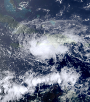
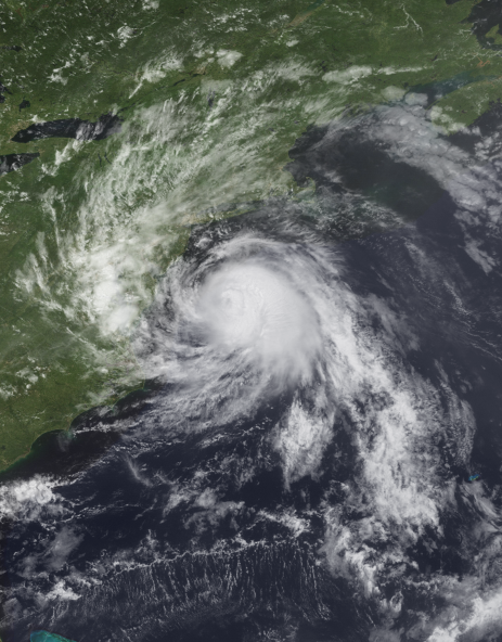
The season began on June 11, with the formation of Tropical Storm Arlene just north of the Bahamas. The storm gradually strengthened as it made a loop, turning to the north-northwest torwards the United States. Arlene began to weaken as it approached land, and came ashore near Georgetown, South Carolina, as a minimal tropical storm. The cyclone rapidly dissipated as it moved faster torwards the Appalachians. The next storm, Bret, formed just 8 days later. It was a brief tropical storm that lasted a little more than a day, making landfall in Cuba. Its remnants came ashore in the Florida Panhandle. After a short period of inactivity, Tropical Storm Cindy developed on July 7. A strong Azores High pushed the cyclone between Bermuda and the Eastern United States, before Cindy managed to recurve and peak just short of hurricane strength south of Nova Scotia. Before long, Cindy became extratropical while located to the west of Newfoundland. The final tropical cyclone of the month of July, Tropical Storm Don, became a highly destructive tropical cyclone which devastated Hispaniola, primarily Haiti. The country was still in a humanitarian crisis nine months after Hurricane Matthew, and Don's impacts only compounded the problem as the storm dumped torrential rainfall due to its slow movement, causing significant flooding. Don made landfall in eastern Dominican Republic, near La Romana a tropical depression, before degenerating to a remnant low. Finally, the remnants regenerated for a short period a day later, before finally dissipating on August 1 after bringing moderate impacts to Bermuda.
Activity ramped up rapidly in August, with the month seeing more storms than all the previous months put together alone. The first storm, Hurricane Emily, originated from the Gulf of Mexico and made landfall as a minimal category 2 in the Big Bend of Florida. It then crossed Florida and paralleled the Southeastern coastline before finally weakening as it headed further inland. A day after Emily, Tropical Depression Six developed, later going on to become Hurricane Franklin and meandering off the coast of North Carolina for several days. After a short lull in tropical activity, Hurricane Gert developed on August 18. For the majority of its lifetime, it stayed well away from land, only coming close to the Cape Verde islands while tropical. The fourth cyclone of the season, Tropical Storm Harvey, was very brief and lasted for only a day before making landfall in extreme southern Texas as a tropical storm. Finally, Category 4 Irma followed a classic Cape Verde track, recurving back to the open Atlantic before managing to strike any land. Despite that, strong swells heavily impacted coastal areas of the United States, the Greater Antilles, and the island of Bermuda.
Despite being considered the most active month of the season, September saw slightly less activity than the previous month. The first ten days did not see an tropical cyclone activity, until Hurricane Jose formed on the peak day of the whole season, September 10. It followed an unusual track though the Caribbean, moving eastward, before striking Puerto Rico and, several days later, the Mid-Atlantic. Jose peaked as a category 3 over open waters. Torwards the end of the month, weak Tropical Storm Katia struck the Northeastern United States as a minimal tropical storm. Heading torwards the end of the month and into October, the sixth Hurricane of the year, Lee, traversed the entire Atlantic from its starting point as a tropical wave near Africa to the Azores, where it became a post-tropical cyclone. Lee peaked as a category 1 midway between The Bahamas and Bermuda.
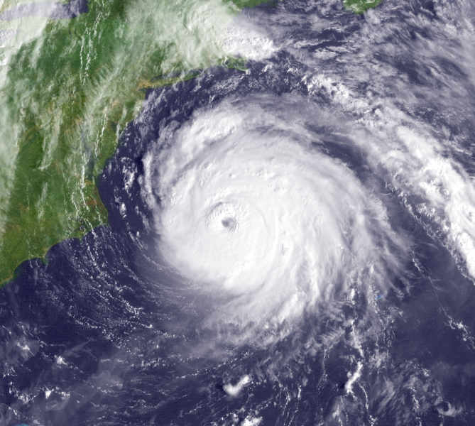
Activity, as expected, began to decline in October. However, the month saw the strongest storm of the season, Hurricane Maria, which peaked at an unusual northerly latitude. After peaking, the storm was ripped apart by wind shear from a strong ULL north of Bermuda at a record pace. Fortunately, no land ever saw a direct strike from Maria. The next storm, Subtropical Storm Nate, coexisted in close proximity with Maria throughout Nate's lifetime. Heavy outflow shear from the powerful hurricane close by greatly limited intensification for the much weaker system to the north, and it remained at tropical depression strength until transitioning to a subtropical storm for the final 12 hours before becoming post-tropical.
During the final month of the season, November, two tropical cyclones developed. The first, Tropical Depression Fifteen, devastated the Gulf Coast, particularly Louisiana. It is commonly compared to the August 2016 Louisiana Floods, which hit the same area causing up to $15 billion (2016 USD) in losses a year earlier. A week later, Tropical Storm Ophelia, hit Florida as a weak tropical storm, with minimal impacts. Ophelia was the last tropical cyclone in the Atlantic within the official seasonal bounds.
The year ended with a bang. Exceptionally rare December Hurricane Philippe hit North Carolina, severely disrupting Christmas preparations. Later, the hurricane trasitioned to a winter storm which brought blizzard conditions in the East and a tornado outbreak to portions of the Midwest. Philippe was the first December hurricane since Epsilon in the record active 2005 Atlantic hurricane season.
The 2017 Atlantic hurricane season generated a total of 106.66 units of Accumulated Cyclone Energy. This is above the 1951-2000 full-season average is 93 units by 13.66 units, making the season slightly above average. The top storm in terms of ACE was Hurricane Irma, which generated a total of 28.3 units, while the lowest was Tropical Storm Bret with only 0.3675 units. Tropical Depression Fifteen did not achieve winds of 35 knots (40 mph), and therefore did not generate any ACE.
Storms[]
Tropical Storm Arlene[]
| Tropical storm (SSHWS) | |
  | |
| Duration | June 11 – June 16 |
|---|---|
| Peak intensity | 60 mph (95 km/h) (1-min) 993 mbar (hPa) |
A tropical disturbance developed over the Bahamas early on June 10. Due to favorable conditions, the wave quickly gained organization. An Air Force reconnaissance aircraft investigated the system at 3:00 UTC on June 11 and found tropical storm-force winds, but reported that the circulation was ill-defined. Another aircraft at 15:00 UTC found that the disturbance had become a tropical storm, and was designated as Tropical Storm Arlene. Maximum sustained winds of 45 mph (70 km/h) and a minimum pressure of 1004 millibars were recorded. The storm was not inhibited by unfavorable conditions, and continued to intensify. As Arlene continued north and began a cyclonic loop, it significantly enlarged in size, spanning from just north of the Bahamas to North Carolina. Shortly before completing the loop, Arlene peaked at 9:00 UTC on June 13 with winds of 60 mph (95 km/h) and a pressure of 993 mbars. After peak, the storm's structure began to rapidly degrade due to increasing wind shear and upwelling of cooler ocean waters. By the time Arlene made landfall slightly more than 48 hours later after peak, on June 15 at 15:00 UTC, winds had decreased to 40 mph (65 km/h) and the pressure had risen to 1009 mbar. The exposed cyclone made landfall near Georgetown, South Carolina, bringing moderate effects to the area. Arlene accelerated to the northwest torward the Appalachians and dissipated 12 hours after landfall.
The majority of damage occurred in the Bahamas during Arlene's development stages. The cyclone's slow movement dropped torrential rainfall on multiple islands of the chain, including some still recovering for Hurricane Matthew of 2016. 15 fatalities and $2 million in damages was recorded. Power outages were extensive in the most severely hit locations. One surfer drowned after strong swells overwhelmed him on the island of Bermuda. In the United States, the primary impact was heavy rainfall. A family of 3 was killed in Lake City, South Carolina when a large tree fell on their home, and a couple died after they lost control of their motercycle on Interstate 95 near Florence. In total, Arlene caused 21 fatalities and approximately $3 million (2017 USD) in losses.
Tropical Storm Bret[]
| Tropical storm (SSHWS) | |
  | |
| Duration | June 23 – June 24 |
|---|---|
| Peak intensity | 40 mph (65 km/h) (1-min) 1008 mbar (hPa) |
A disorganized group of thunderstorm activity formed just south of Jamaica on June 21. It struggled to consolidate as strong wind shear dominated the area. Steadily moving northwestward torwards the Yucatán Channel, the wave began to resemble a subtropical cyclone, with the circulation remaining largely displaced from the primary convection. Late on June 22, a narrow area of more favorable conditions developed ahead of the system, allowing for some strengthening of the low pressure area and a more tight circulation. Finally, at 15:00 UTC, the wave was deemed a tropical depression after gaining sufficient organization, supported by data from a reconnaissance aircraft. Tropical Depression Two had wind speeds of 35 mph (55 km/h) and a pressure of 1008 millibars, which later became its peak intensity. Not long after formation, Two made its first, and only, tropical landfall near the municipality of Sandino, Cuba. A frontal boundary to the west forced the storm onto a more due north track as it moved away from the island nation. Despite moving over land, the depression strengthened slightly to a weak tropical storm, and was designated as Tropical Storm Bret. Unusually, the pressure did not fall, but rose instead. Bret managed to maintain tropical storm status for 18 hours before becoming Post-Tropical due to hostile conditions. Its remnants came ashore near Apalachicola, Florida and fully dissipated over Georgia.
Minimal impacts were recorded in Cuba and in the Southeast from Bret. 1 fatality was reported when a woman went missing and was later presumed dead in Cuba. Beaches across the Gulf coast were closed to prevent beachgoers from entering the high surf, but were reopened shortly after as Bret fell apart quickly and never caused the disruption that was previously forecasted.
Tropical Storm Cindy[]
| Tropical storm (SSHWS) | |
  | |
| Duration | July 7 – July 11 |
|---|---|
| Peak intensity | 70 mph (110 km/h) (1-min) 985 mbar (hPa) |
The tropical wave that led to the formation of Cindy began to take shape north of the Lesser Antilles. A conducive environment favored rapid development of the low. While located approximately 255 miles north-northeast of Samaná in the Dominican Republic, the now-well organized tropical wave became a tropical depression at 03:00 UTC on July 7. After designation, Tropical Depression Three continued on a strengthening course throughout the afternoon. At 15:00 UTC, the National Hurricane Center upgraded the cyclone to a tropical storm, naming it Cindy. Some minor strengthening occurred throughout the day despite increasingly detrimental conditions caused by dry air from the Azores High. Cindy reached its first peak at 9:00 UTC on July 8 with 1-minute sustained winds of 50 mph (80 km/h) and a pressure of 999 mbars. Subsequent weakening began as dry air entrained itself into the storm's circulation. Originally expected to continue on a northwestern track torwards a landfall on the Delmarva Peninsula, Cindy instead started to recurve around Bermuda. Restrengthening ensued as the cyclone exited the strip of unfavorable dry air stationed south of the island. It inflicted little damage to the territory as it passed safely to the north on a northeast trajectory. Baroclinic processes allowed Cindy to strengthen quickly as it headed torwards the Canadian Maritimes, and it reached peak intensity at 21:00 UTC, July 10, while situated south of Nova Scotia with winds of 70 mph (110 km/h), partnered with a minimum central pressure of 985 millibars. Now forecasted to briefly reach hurricane status, Cindy once again defied predictions by quickly beginning to take on extratropical characteristics. It officially completed the transition at 15:00 UTC on July 11, and the last advisory was issued by the National Hurricane Center.
No significant were caused by Cindy throughout its lifespan, although it did come close to land on several occasions. Strong wind gusts caused some disruption in Nova Scotia and Newfoundland, with the latter seeing more widespread impacts as the storm's center passed closer to the province. Downed tree limbs resulted in isolated blocked roads and downed power lines. Fortis Incorporated and Nova Scotia Power reported that 10,000 to 25,000 people were without power as Cindy impacted the region. Most power was restored within the next 2 days in the Atlantic Maritimes.
Tropical Storm Don[]
| Tropical storm (SSHWS) | |
  | |
| Duration | July 27 – August 1 |
|---|---|
| Peak intensity | 50 mph (85 km/h) (1-min) 1004 mbar (hPa) |
An African Easterly wave exited the coast of Africa with little convective organization, as a Saharan Air Layer prevented the low from strengthening. The wave crossed the Main Development Region uneventfully, but when it reached the Caribbean, where conditions were much more favorable for tropical cyclogenesis, immediate changes began to occur. Due to very moist air and low wind shear, the cloud tops began to rise and cool significantly, whilst becoming more numerous. The wave began to take on a similar look to that of a tropical depression, prompting the National Hurricane Center to designate the system as an invest. On July 27, after an Air Force reconnaissance flight found a closed circulation, Tropical Depression Four was declared to have formed south of Hispaniola at 9:00 UTC. The tropical depression strengthened to a tropical storm 6 hours later at 15:00 UTC, and was named Don. Until July 28, Don continued in a westward direction before becoming nearly stationary south of Haiti. Tropical Storm Warnings were hoisted by the Haitian government that ran throughout the southern coast. Meanwhile, Don briefly stalled, before starting on a sharp eastward path. The small storm peaked at 21:00 UTC on July 28. The winds reached 50 mph (85 km/h) and the pressure dropped to 1004, before the mountains of Hispaniola began to interfere with Don's cyclonic structure. In a very weakened state, Don made landfall as a tropical depression at 3:00 UTC, July 30, in the far east of the Dominican Republic, near the city of La Romana. Crossing the island caused even further weakening, and Tropical Depression Don degenerated into a remnant low. A day later, moderately favorable conditions allowed the remnant low to regenerate into a tropical storm, becoming Don's second stint as a tropical cyclone. It did not last long as cooler ocean waters began to take their toll, and by August 1 the storm became post-tropical after briefly brushing Bermuda as a subtropical cyclone. The post-tropical low dropped light rain along coastal areas of New England, however no damage was reported.
Devastation in Haiti was widespread, caused by the torrential rainfall which lasted for two days as Don slowly moved. The nation was still recovering from the recent strike by Hurricane Matthew less than a year prior, and the humanitarian crisis that followed suit. Many survivors still had no homes and were living in tents when Don impacted the island, and the ensuing flooding swept away hundreds of poorly constructed homes and tents, which housed many people whose residence had been destroyed by Hurricane Matthew. In total, an estimated 400-450 deaths in Haiti were reported, many of which were the result of homes getting swept away by rushing floodwaters. In the Dominican Republic, damage was less severe, and most homes remained standing. There was a sharp contrast between the two countries, as the economic situation allowed for better constructed homes in the Dominican Republic than in that of Haiti, which is one of the poorest nations in the world. In it's last days of existence, Don moved just west of Bermuda, with no damage or casualties. In total, Don is estimated to have caused up to 500 deaths and 967 million in destruction.
Hurricane Emily[]
| Category 2 hurricane (SSHWS) | |
  | |
| Duration | August 2 – August 8 |
|---|---|
| Peak intensity | 100 mph (155 km/h) (1-min) 971 mbar (hPa) |
The first hurricane of the season formed from an area of low pressure with the potential for tropical development that was first noted by the National Hurricane Center on July 31, while located in the Bay of Campeche. Thunderstorm activity was numerous throughout the system despite it having only formed the previous day. Development was slowed slightly by the close proximity of land from nearby Mexico, but the drifting disturbance's extensive time over warm waters allowed it to counteract any weakening. On August 2, the National Hurricane Center announced that Tropical Depression Four had formed after maintaining persistent thunderstorm and organization for the past two days. A high pressure system over Texas caused the newly formed storm to curve to the northeast in the direction of Florida. Gradually strengthening, Four reached tropical storm status at 03:00 UTC on August 4, and was given the name Emily. Over the next day or so, Tropical Storm Emily intensified slowly, with moderate wind shear in the central Gulf. On August 5, as the storm was nearing hurricane status, tropical storm watches and warnings were issued for Florida's entire western coast, due to uncertainty in Emily's forecast path. These warnings were later discontinued for much of the Panhandle after it became clear that the storm was going to make landfall further south. At 15:00 UTC on August 6, the NHC reported that Emily had officially strengthened into a hurricane, with winds of 75 mph (120 km/h) and a pressure of 984 millibars. In the last day prior to landfall, a period of quick intensification began, believed to be the cause of the Florida Continental Shelf. The following day, Emily came ashore near the community of Homosassa Springs in Citrus County, Florida at 09:00 UTC. Winds were estimated to be at 100 mph (155 km/h); the pressure was recorded to be at 971 millibars. Accelerating to the the northeast, Emily crossed Florida several hours later and entered the Atlantic Ocean. Now in a steady weakening stage, the storm made its second landfall in South Carolina just north of Myrtle Beach, not far from the North Carolina border. Winds had decreased to 80 mph (130 km/h) due to land interaction with Florida, but Emily remained at formidable strength. After landfall, Emily began to weaken substantially as it was eventually pulled in by a frontal boundary over Pennsylvania and lost all tropical characteristics on August 9 around 03:00 UTC.
Most damage came from areas in western Florida and the Mid-Atlantic, where the front later dropped large amounts of rainfall and then spawned the largest New England tornado outbreak in history. In Florida, Emily's peak storm surge of about 6 feet caused moderate property damage along the immediate coastline. Wind was the primary cause of damage further inland. In North Carolina, an EF0 tornado briefly dropped down in a field, becoming the first record hurricane-related tornado of the year. In the end, Hurricane Emily caused $45 million (2017 USD) in property loss and 12 fatalities.
Hurricane Franklin[]
| Category 1 hurricane (SSHWS) | |
  | |
| Duration | August 3 – August 14 |
|---|---|
| Peak intensity | 75 mph (120 km/h) (1-min) 998 mbar (hPa) |
The precursor to Hurricane Franklin was a long-tracked African Easterly Wave that had exited the coast of Africa almost a week earlier. Originally showing little signs of development while crossing the Main Development Region, changes eventually began to occur as the open low turned to the northeast under the influence of a high pressure ridge. The system was invested by the National Hurricane Center on August 1, but development was deemed unlikely. However, the invest continued to organize, and was unexpectedly upgraded to the sixth depression of the 2017 Atlantic hurricane season at 5 am EDT (09:00 UTC) on August 4. An unusual dip in the jet stream caused the newly Tropical Depression Six to become nearly stationary and almost dissipate due to the sudden increase in wind shear. Barely managing to remain intact, the depression started to move to the southwest, along the leading edge of the jet stream. Despite the inhibiting factors, it managed to strengthen slowly, finally reaching tropical storm status on August 6 around midday local time (11 am EDT, 15:00 UTC). It was given the name Franklin, and had winds of 40 mph (65 km/h), while the pressure was estimated to be 1007 mbar. Some more meager intensification occurred, peaking at 45 mph (75 km/h), before the tropical storm began to interact with the nearby Hurricane Emily. Subsequent weakening started as the cyclone neared the southeast coastline, and it lost tropical storm intensity on August 7. Just shortly before making landfall, Franklin veered to the northeast, pulled by the rapidly degenerating Emily. Before being able to absorb the smaller storm to its south, Emily was absorbed by a frontal boundary which then positioned itself to the north of Franklin, once again causing it to slow down. Paralleling the shore, the center and most intense winds remained just a few miles offshore, resulting in minimal damage. A maximum storm surge of 3 feet was reported at South Port, North Carolina, where the small inlet exacerbated wave height. Moving away from land, Franklin strengthened once more to a tropical storm. Not long after doing so, the tropical storm made a sharp u-turn to the south for the second time. Feeding on warm Gulf Stream waters, it began to intensify, and Franklin attained minimal hurricane status on August 12. Winds peaked at 75 mph (120 km/h), and the pressure reached its lowest at 998 millibars. Immediately following that, Hurricane Franklin began to weaken as it executed its third and final u-turn, this time to the northeast. The storm lost hurricane intensity by August 13, finally accelerating away from the southeast coast after meandering there for almost a week. Franklin lost tropical characteristics at 5 am (09:00 UTC), August 14, as the final advisory was issued on the post-tropical low.
Despite spending such a prolonged time near land, Franklin's impacts were largely insignificant, with only 1 fatality and minimal damage. When Franklin became a hurricane, it was the first time that a storm with the name has reached hurricane strength.
Hurricane Gert[]
| Category 1 hurricane (SSHWS) | |
  | |
| Duration | August 18 – August 27 |
|---|---|
| Peak intensity | 90 mph (150 km/h) (1-min) 973 mbar (hPa) |
Several waves that had developed over Africa were monitored for potential development as they entered the Atlantic. The first soon developed into Tropical Depression Six. The other later went on to spawn Hurricane Irma, a powerful category 4 hurricane. A complete lack of the Saharan Air Layer, one of the usual detrimental factors to disturbances exiting Africa, allowed Six to begin strengthening upon formation. Around 21:00 UTC, August 18, despite forming only 18 hours earlier, it was officially classified as a tropical storm by the National Hurricane Center, making Tropical Storm Gert the seventh named storm of the season. The center of the newly-formed tropical storm was located just 230 miles south of Praia, the capital and largest city of Cape Verde. Due to the proximity, some of the outer bands brushed the Salavento Islands of the chain, but no damage was reported to have been caused by Gert. Progressively moving away to the west, Tropical Storm Gert strengthened at a steady rate for the next 3 days. On August 21, the storm reached category 1 hurricane strength; the third hurricane of the season and of the month of August. Hurricane Gert soon reached its peak on August 22, at approximately 15:00 UTC, with 90 mph (150 km/h) winds and an estimated minimum pressure of 973 millibars. The peak was short lived, however, and after only 12 hours weakening began as wind shear increased around the storm. Gert lost hurricane status around early evening on August 23 while drawing closer to the northern Lesser Antilles. Curving because of a ridge, the cyclone avoided striking land and began to retreat to the northeast, and attained hurricane status for the second time early on August 26, helped by baroclinic processes to do so. Gert attained its secondary peak that same day at 21:00 UTC; highest winds reached 75 mph, while the pressure dipped slightly to 989 mbar. Cooler waters and higher vertical wind shear began to tear the storm apart not long after peaking as it headed further north torwards to the Azores. Losing intensity, Gert transitioned to a strong extratropical cyclone on August 18 as it sped past the Azores torwards Iceland.
Throughout its lifetime, Gert stayed well away from land, causing no fatalities and minimal damage, mostly in Cape Verde.
Tropical Storm Harvey[]
| Tropical storm (SSHWS) | |
  | |
| Duration | August 22 – August 23 |
|---|---|
| Peak intensity | 45 mph (75 km/h) (1-min) 1006 mbar (hPa) |
For several days prior to any activity, the Bay of Campeche was monitored as an area of potential tropical cyclogenesis. Models consistently remained in agreement that a weak tropical cyclone was likely in the upcoming week. When a weak low developed over Mexico, it was immediately marked by the National Hurricane Center for the possibility of further development. Moving northward, the low moved over the bay and a sudden increase in organization occurred. This warranted an Air Force hurricane hunter aircraft to investigate for signs of tropical transition. Upon collecting enough information, it was found that a tropical depression had rapidly developed in just 24 hours after entering the Bay of Campeche. At 06:00 UTC on August 22, a special advisory was issued by the NHC announcing that Tropical Depression Eight has formed. Landfall was expected before any strengthening could begin, but only 6 hours later the depression strengthened to a tropical storm and was named Tropical Storm Harvey. Upon landfall, Harvey peaked with maximum sustained winds measured at 45 mph (75 km/h), while the pressure was recorded at 1006 millibars. The storm made landfall near the city of Brownsville, Texas, causing some moderate damage. Heading inland, the desert conditions began to take their toll on Harvey's structural integrity. 15 hours after landfall, the remains of the tropical storm dissipated over south-central Texas on August 23.
For some time, it was heavily debated in which country Harvey made landfall, but after close analysis it was determined that Harvey crossed onto land just several miles north of the border in Texas. Regardless of landfall location, some considerable damage was done by the storm. In total, about $22 million (2017 USD) in losses were attributed to Harvey, particularly in Mexico. Fortunately, no fatalities were reported.
Hurricane Irma[]
| Category 4 hurricane (SSHWS) | |
  | |
| Duration | August 22 – August 31 |
|---|---|
| Peak intensity | 145 mph (230 km/h) (1-min) 932 mbar (hPa) |
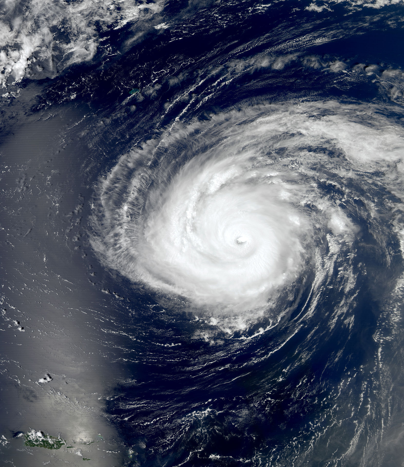
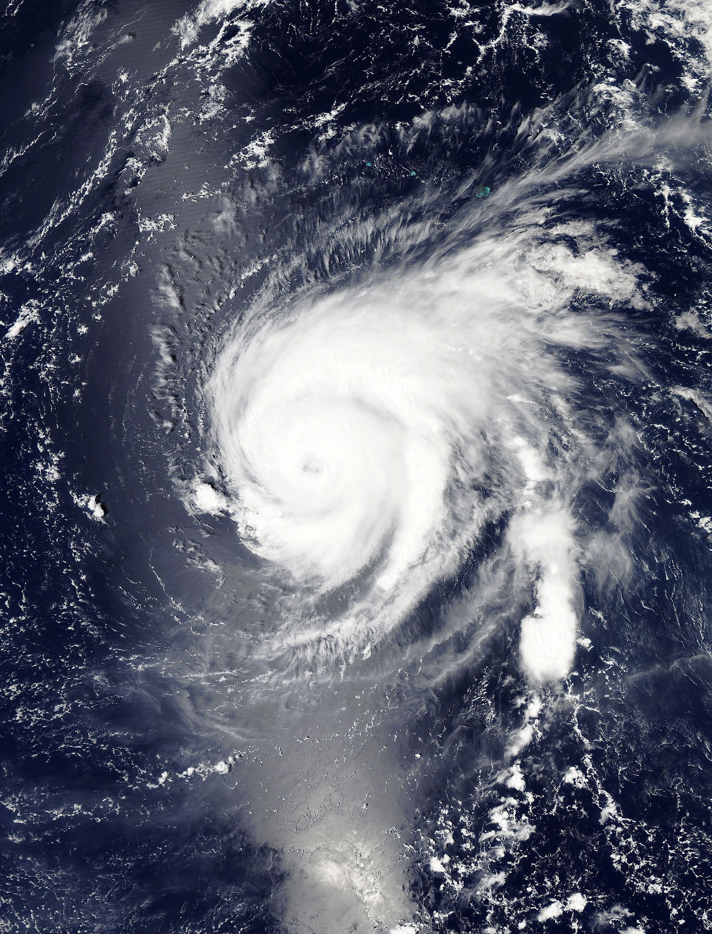
The second tropical wave that exited the coast of Africa after the wave that became Hurricane Gert passed Cape Verde without much avail. Moving west into the central Main Development Region, thunderstorm activity gradually began to increase, fueled by above-average sea surface temperatures. The area of disturbed weather was soon invested by the National Hurricane Center and was given the invest number 98L. Changing course to the northwest, Invest 98L continued to become better organized at a steady state. A NASA Global Hawk unmanned aircraft investigated the system around midday on August 22, finding that the system has become a weak tropical depression with winds estimated at 30 mph, but a rather low pressure of 1000 millibar at 15:00 UTC. Strengthening at an unchanging rate, Tropical Depression Nine became Tropical Storm Irma 24 hours later, the ninth named cyclone of the season. After doing so, increasing shear resulting from nearby Hurricane Gert began to slow the intensification of the storm further, and it appeared that a weakening process would begin shortly. However, as Gert began to lose strength, the window for Irma to increase in intensity reopened. Two days later, it was reported that the tropical storm had become a hurricane based on satellite estimates. A central dense overcast (CDO) began to develop shortly after. Unexpectedly, a period of rapid strengthening began on August 26, catching many forecasters and computer models off guard. By the end of the day, the hurricane was a strong category 3 with winds of 125 mph. The pressure had dropped significantly to 954 mbar. Earlier, the maximum sustained winds were 80 mph; the pressure had lay stagnant at 977. Continuing to deepen, the storm reached category 4 status 6 hours later while situated to the northeast of the Lesser Antilles. Due to it's strength, severe swells were expected to slam coastal areas that were on the north side of the islands. Irma finally peaked at 09:00 UTC on August 28 with maximum 1-minute sustained winds reaching 145 mph and the pressure bottoming out at 932 mbar. After peak, the intensity began to regress as Irma turned on a northward path, east of Bermuda. By the next day, the major hurricane had weakened to a category 3. Losing intensity more rapidly after turning for one final time torwards the central Atlantic Ocean. Picking up in speed, Hurricane Irma became a powerful hurricane-force extratropical cyclone and began to deepen once more. However, as it was no longer tropical, the final advisory was issued by the National Hurricane Center at 21:00 UTC, August 31.
Rough waters from Irma claimed 3 lives, including 1 in Puerto Rico and 2 on the East Coast of the United States.
Hurricane Jose[]
| Category 3 hurricane (SSHWS) | |
  | |
| Duration | September 10 – September 18 |
|---|---|
| Peak intensity | 115 mph (185 km/h) (1-min) 965 mbar (hPa) |
A large and messy tropical system developed over the southwestern Caribbean from a stationary low pressure area that had moved north from South America a week prior. Abundant atmospheric moisture, warm SSTs of up to 29 °C, and generally low shear favored quick strengthening. The large nature of the system prevented such intensification from occurring, instead slowly moving westward before making a 180 degree turn to the east-northeast. Upon completion of the loop around 03:00 UTC, the system was declared as Tropical Depression Ten early on the morning of September 10. Ten formed in almost the exact same location as its precursor low pressure area. Before long, Ten moved away on a steady trajectory torwards the eastern Dominican Republic. A day later, the tropical depression was found to have strengthened further by a NOAA reconnaissance aircraft, and on September 11 it was upgraded to a minimal tropical storm with 40 mph (65 km/h) maximum sustained winds. The name Jose was given to the new tropical storm, making it the tenth named storm of the 2017 Atlantic hurricane season. A small wobble in Jose's movement resulted in the forecast path being shifted torwards Puerto Rico, and a tropical storm watch was issued for the island. Jose was now moving east, an unusual direction for a storm in this location. Strengthening slowly throughout the previous day, the storm began to curve to the north on September 12. The tropical storm warning already set in place for the whole island was soon upgraded to a hurricane warning when the National Hurricane Center found that Jose had become a category 1 hurricane at 15:00 UTC (11 a.m local time). At the time, it was located south of the island, moving north with sustained winds of 75 mph (120 km/h), while the pressure decreased steadily to 984 millibar at the time of the advisory. Scraping by Puerto Rico, the eye stayed several miles offshore. However, intense hurricane force winds still lashed a large portion of the island and the nearby Dominican Republic. Due to land interaction, Jose weakened below hurricane status as the eye disappeared off satellite not long after. For the next 24 hours, Jose continued to fluctuate between strong tropical storm and minimal category 1 hurricane status. Finally leveling out, gradual intensification began once more. Curving to the northwest, the intensifying hurricane was set on a trajectory torwards the Mid-Atlantic United States. In the early hours on September 15, the NHC upgraded Jose to a category 2 with windspeeds of 100 mph (155 km/h). Later that day, after further intensification, it was found that the hurricane had reached category 3 status. Simultaneously peaking, maximum sustained winds of 115 mph (185 km/h) were recorded, and a pressure of 965 mbar was measured by a dropsonde. Hurricane warnings were hoisted for areas from east-central North Carolina to southern New Jersey in preparation for the approaching storm. 6 hours after peak, Jose began to weaken as it came closer and closer to land. The hurricane made its first landfall in Virginia on the Delmarva Peninsula as a category 1 in the evening hours of September 16. Moving swiftly over the small land mass, Jose continued up the Chesapeake Bay before making a second landfall in eastern Maryland. After coming ashore, winds began to rapidly decrease throughout the day on September 17. Crossing into Canada at a high forward speed, the last advisory for the former hurricane was issued by the NHC at 03:00 UTC, September 18, exactly eight days after Jose originally formed in the southwestern Caribbean Sea. The remnants of Jose later transitioned into a powerful extratropical cyclone that produced hurricane-force winds over much of the Arctic Ocean.
Hurricane Jose caused significant damage throughout Puerto Rico, Hispaniola, and the mid-Atlantic. Heavy precipitation caused numerous deaths after homes were swept away in mountainous regions of the two islands. Besides that, several large mudslides were reported as well. In the Mid-Atlantic states, heavy storm surge destroyed portions of the Chesapeake Bay Bridge-Tunnel system, and both tunnels were heavily flooded. Also, it was the first recorded instance of hurricane-force winds in Baltimore, impacting the city for almost 12 hours. Many states on the northeastern Atlantic seaboard declared State of Emergencies for the crisis, and federal aid was distributed to the affected areas after the storm. In total, the exact amount of losses is unknown, but it is estimated that Hurricane Jose caused up to $21 billion in damages and 73 fatalities.
Tropical Storm Katia[]
| Tropical storm (SSHWS) | |
  | |
| Duration | September 24 – September 25 |
|---|---|
| Peak intensity | 50 mph (85 km/h) (1-min) 999 mbar (hPa) |
An area of low pressure attached to a decaying frontal boundary was monitored by the National Hurricane Center for potential tropical cyclogenesis. Formation was generally not expected as it was located in an area of high vertical wind shear. Despite being north of Bermuda, sea surface temperatures were still warm enough to support a tropical cyclone, at 28 °C. Breaking away from its parent front, the area of disturbed weather began to move in a southwesterly direction. Making it past Bermuda, it then turned back around to the north, under the influence of another developing tropical wave located near the Bahamas. Increasing confidence of a potential tropical cyclone and strike on the Northeast led the NHC to initiate advisories on Potential Tropical Cyclone One, the first such designation of the season. Acquiring a closed circulation, One quickly became a tropical storm and was named Katia at 21:00 UTC. The eleventh tropical storm of the season, Katia had sustained winds of 50 mph (85 km/h) and a pressure of 999 millibars at formation. This later became the peak intensity of the tropical storm, partly due to the origins of the low pressure area resulting in a generally lower pressure. Racing north, Katia made landfall just 13 hours after designation near Falmouth, Massachusetts. Continuing at its quick clip, the tropical storm came ashore for the second and final time in Maine that same day, September 25. Due to the rapid movement of the storm, Katia managed to make it to Nova Scotia before being declared post-tropical. In total, Katia lasted only 30 hours as a tropical cyclone. The non-tropical remnant continued into the open North Atlantic before being absorbed by the same frontal boundary it had come from.
Effects from Tropical Storm Katia were relatively mild in the Northeast and Atlantic Canada. The most widespread damage was caused by trees. Minor coastal flooding inundated some areas for a short amount of time before receding again as the storm moved away. Total losses are estimated to be about $1 million (2017 USD), and no lives were claimed.
Hurricane Lee[]
| Category 1 hurricane (SSHWS) | |
  | |
| Duration | September 29 – October 6 |
|---|---|
| Peak intensity | 85 mph (140 km/h) (1-min) 978 mbar (hPa) |
Increasing convection on a tropical wave located north of Puerto Rico caught the attention of the National Hurricane Center. The wave had originated from Africa, but struggled to produce much persistent thunderstorm activity as wind shear had begun to increase in the MDR with the latter part of the season. At first, the wave was expected to rapidly dissipate near the Bahamas, and was given a very low chance of tropical cyclone formation. However, this began to change when atmospheric observations showed a potentially conducive environment with little vertical wind shear to disrupt organization. Following this development, the likelihood of a tropical depression forming began to quickly increase. Passing the Turks and Caicos, Invest 92L was designated with a high chance of cyclogenesis. Just 24 hours later, a scheduled NOAA recon flight found that Tropical Depression Twelve has rapidly formed since the last ASCAT pass, which had shown an apparent open low. Advisories were initiated at 15:00 UTC with maximum sustained winds at 35 mph (55 km/h), while the center was located near the central Bahamian island of Eleuthera. After designation, Thirteen made a sharp turn to east-northeast (ENE). Strengthening, Lee was named at 09:00 UTC the next day, September 30. After that, the tropical storm began to undergo a period of short lasting bouts of rapid intensification, assisted primarily by the warm SSTs of the Gulf Stream and a favorable environment with low shear and high moisture. 24 hours after being named, reconnaissance found that Lee was a low-end Category 1 hurricane with windspeeds of 80 mph (130 km/h). Continuing to improve on satellite, the NHC increased the winds further to 85 mph (140 km/h) and lowered the pressure to 980 millibars. Hurricane Lee peaked 6 hours later with the estimated pressure at 21:00 UTC bottoming out at 978 mbar. Located approximately midway between Bermuda and The Bahamas, increasing wind shear began to take its subsequent toll on the system on the next day after peak, October 2. Lee lost hurricane intensity at 03:00 UTC on October 3 but managed to fight off further weakening. Increasing in forward speed, convection finally collapsed as SSTs became too low to support the storm by October 4. The last advisory on Lee was issued at 03:00 UTC on October 6 when the tropical storm fully transitioned to an extratropical cyclone several hundred miles west of the Azores.
No deaths were reported to be in relation to Hurricane Lee. Minimal damage did occur during Lee's precursor stages.
Hurricane Maria[]
| Category 4 hurricane (SSHWS) | |
  | |
| Duration | October 15 – October 22 |
|---|---|
| Peak intensity | 150 mph (240 km/h) (1-min) 929 mbar (hPa) |
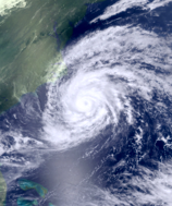
One of the last significant waves to emerge from Africa, the precursor tropical wave initially struggled to sustain itself. A combination of factors kept it at bay until it began to move northwest out of the central tropical Atlantic. Taking advantage of a relatively small strip of better conditions, thunderstorms began to sprout around the center while it attempted to align itself vertically. Eventually, data from a microwave pass supported designation for a new tropical depression over the open Atlantic, some distance northeast from the northern extremities of the Lesser Antilles. The center remained somewhat exposed on the west side, which prevented much strengthening in the short term of 24–48 hours. Initial model and NHC forecasts proved to be accurate, and Tropical Depression Thirteen was upgraded to a tropical storm on October 16, 36 hours after genesis. Beyond that point, there remained great uncertainty in the future intensity of the storm as it was getting late in the season for a strong storm at that latitude. However, Tropical Storm Maria soon entered an environment prime for rapid intensification. Over the next 2 days, Maria's intensity increased from a weak tropical storm with 40 mph (65 km/h) winds to a strong category 3 hurricane with sustained winds of 120 mph (195 km/h), an 80 mph (130 km/h) increase. After a brief trip up, strengthening continued throughout the afternoon on October 19, and, despite being level with North Carolina, reconnaissance found that Maria has become a category 4 hurricane. Explosive intensification went on for another 12 hours, finally stopping at 03:00 UTC the following day. Upon peak, Maria became the strongest storm of the season, beating Hurricane Irma by 2 millibars. Satellite estimations showed that the hurricane maxed out at 150 mph (240 km/h), 929 millibar. Even faster than it had intensified, drastic weakening occurred over the following 24 hours from shear created by a powerful upper level low (ULL) that had moved in over Bermuda. At 03:00 UTC on October 21, winds had decreased to 100 mph (155 km/h). At the next advisory, Maria was downgraded to a strong tropical storm. Not letting up, shear tore up the storm at an extreme pace and the remains were absorbed by the ULL the next morning.
Although not having any significant land impacts other than strong ocean swells, Hurricane Maria generated a lot of attention from the media due to the unusual strength for its location. Many hurricane forecasters said that the sudden changes made it very difficult to forecast the hurricane; a complex pattern resulted in early forecasts indicating a strike on New York City. This did not occur, but meteorologists echoed that the city is becoming more vulnerable to tropical cyclone impacts as global warming progresses further.
Subtropical Storm Nate[]
| Tropical storm (SSHWS) | |
  | |
| Duration | October 19 – October 22 |
|---|---|
| Peak intensity | 40 mph (65 km/h) (1-min) 1006 mbar (hPa) |
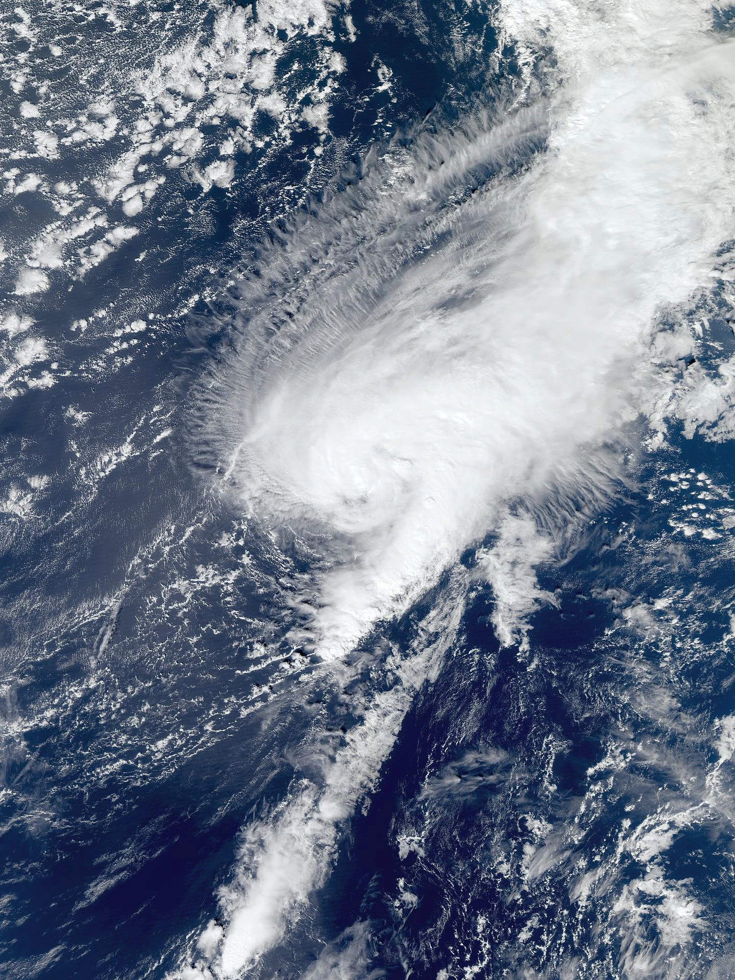
The low pressure that went on to become Nate was first spotted over western Florida in relation with a front draped over the state. Eventually, it began to break away from the parent system—which had begun to move southward—by instead moving to the northeast, emerging over Atlantic waters near Daytona Beach. Becoming increasingly decoupled, the precursor weakened below 40 mph (65 km/h). Later that day, it was reported that the center had relocated under the primary convection. This finally allowed the system to become tropical, and at 00:00 UTC, October 19, the NHC issued a special advisory about the formation of Tropical Depression Fourteen. Diurnal maximum greatly assisted Fourteen's formation, but beyond that point very close proximity to Hurricane Maria stopped the depression from becoming any stronger, subsequently inducing weakening due to high outflow shear. It appeared likely that Maria would absorb Fourteen, but before this could occur the category 4 collapsed and the tropical depression passed to the west. No longer heavily sheared, slow re-strengthening began around midday August 21. Fourteen began to take on subtropical characteristics, and the transition was completed when Subtropical Storm Nate was declared on August 22. The intensity did not last long, however, with shear increasing once more from the upper level low and now-Tropical Storm Maria, leading to Nate's demise just 12 hours later that same day. The remnants began a brief fujiwhara with the post-tropical remains of Hurricane Maria before they were absorbed together by the ULL.
No damage was caused by Subtropical Storm Nate whilst advisories were issued by the National Hurricane Center. The frontal boundary that the cyclone originated from dropped moderate amounts of rain on central Florida.
Tropical Depression Fifteen[]
| Tropical depression (SSHWS) | |
  | |
| Duration | November 1 – November 4 |
|---|---|
| Peak intensity | 35 mph (55 km/h) (1-min) 1007 mbar (hPa) |
Tropical Depression Fifteen began as an area of disturbed weather that had moved off the coast near Corpus Christi, Texas. Caught in weak steering currents, the low initially headed southwards, before making a sharp turn to the northesst. Warm waters in the Gulf of Mexico aided the tropical system, and cloud tops began to progressively grow cooler, signaling further development. The National Hurricane Center marked the zone on October 30 as Invest 99L with a medium chance of tropical cyclogenesis in the next 2 days. One thing fighting against it was moderate wind shear, which would continue to plague the future depression until dissipation. By November 1, it was becoming clear that a tropical cyclone will form from the Invest and a reconnaissance flight confirmed the exitence of a closed center later that day. Advisories were soon initiated on Tropical Depression Fifteen as it turned torwards the United States. Tropical Storm Watches were issued for the coastal parishes of Plaquemines east to the border with Saint Mary parish after another aircraft found a stronger Fifteen on November 2. Although not strengthening much, flooding was expected to be widespread due to the slow movement of the system. Impacts were already beginning to be felt across the eastern portions of the state, with numerous high-precipitation thunderstorms coming ashore. They gradually increased in coverage as the depression neared land. On November 3, one final flight into the depression at 12:00 UTC recorded peak sustained winds of 35 mph (55 km/h) and a minimal barometric pressure of 1007 mbar. Tropical Depression Fifteen officially made landfall at 03:00 UTC the following morning. Torrential rainfall was dropped on a wide swath of Louisiana and parts of Mississippi. After crossing onto land, the circulation degraded rapidly and was no longer distinguishable just several hours later. The final advisory was issued as Fifteen opened up into a trough while continuing to drop heavy rain on the region.
In preparation for the storm, Louisiana Governor John Bel Edwards issued a state of emergency for 27 parishes, including Baton Rouge and New Orleans. Sand bags were distributed and voluntary evacuations were announced for isolated towns on the flood prone Mississippi Delta. As expected, flooding as a result of the depression was significant. Much of the affected areas saw up to 20 inches of rainfall, locally higher. This made river water levels rise above flood stage. Several communities ended up completely cut of by flood water and required air lifting from the Coast Guard. After the storm passed, the water took up to a month to recede. Total economic losses are estimated to be around $17 billion (2017 USD), with 101 lives claimed. Effects were so severe that the US even appealed to the WMO to have the number retired, but it was eventually denied at the 40th session of the RA IV hurricane committee in April 2018.
Tropical Storm Ophelia[]
| Tropical storm (SSHWS) | |
  | |
| Duration | November 13 – November 18 |
|---|---|
| Peak intensity | 65 mph (100 km/h) (1-min) 992 mbar (hPa) |
Located just north of Hispaniola, a disorganized tropical wave began to take shape. Conditions were favorable enough for a weak tropical system to form. However, the wave was on a track torwards the Gulf of Mexico, where conditions were poor for a tropical cyclone. Meanwhile, the warm tropical waters from the Loop Current were helping to increase the size and strength of thunderstorms around the center. As a result, a NOAA aircraft managed to find a small, albeit weak, closed center on November 13. Tropical Depression Sixteen was officially designated at 15:00 UTC in the first National Hurricane Center advisory on the system. Winds were found close to tropical storm strength, near 35 mph (55 km/h), while a dropsonde measured a pressure of 1012 mbar. Tropical Storm Watches were issued for most of the Florida Keys in the event of further strengthening. In the Florida Straits, Sixteen was upgraded to tropical storm status at 09:00 UTC on November 14, earning the name Ophelia. The most intense winds remained offshore due to Ophelia's tight core structure, with Key West narrowly escaping stronger impacts from the tropical storm. Entering the Gulf, environmental conditions began to progressively get worse, and Ophelia became a tropical depression once more. A ridge made Tropical Depression Ophelia recurve back torwards land, of which upon completion brought it to the warmer, shallower waters of the Florida Continental Shelf. Using this as an advantage, Ophelia restrengthened a little just before landfall near Crystal River, Florida. This was just several miles north of the location where Hurricane Emily had struck 3 months earlier. Although time spent over land was brief, it was enough to render weakening of the storm. Crossing onto water as a tropical depression, anomalous warm water from the Gulf Stream was encountered immediately; therefore it did not take long for windspeeds to start increasing yet again. At 09:00 UTC on November 17, Ophelia regained tropical storm status for the third and final time. Over the next 24 hours, the intensity jumped up to 65 mph (100 km/h), 992 mbar. The storm peaked at 09:00 UTC, November 18, while located some distance east from Virginia. Tropical Storm Ophelia went post-tropical six hours later.
Ophelia made landfall in Citrus County, Florida, as a weak tropical storm. Along with category 2 Hurricane Emily, this was an unusual occurrence when two tropical cyclones struck the same county in one season. There were some difficulties calculating the damage as some areas were still recovering from the first storm. Other than that, Ophelia made close passes to the Keys and Mid-Atlantic as tropical storm. Some sporadic showers with heavy downpours did come onshore, but the primary threat for those locations was increased swell and rip currents. Fortunately, no lives were lost to the storm.
Hurricane Philippe[]
This is a gift storm for my great friend Bob. I added some extra spin to this storm for fun. Enjoy!
| Category 1 hurricane (SSHWS) | |
  | |
| Duration | December 9 – December 11 |
|---|---|
| Peak intensity | 80 mph (130 km/h) (1-min) 987 mbar (hPa) |
Even though it was now December, outside of the official season, the National Hurricane Center began monitoring an extratropical cyclone that crossed Florida. Now over the still-very warm waters off the west coast of Florida, the cold-cored cyclone began to attempt tropical formation. Conditions favored this, the pocket of remarkably low shear lay in the forecast trajectory of the system. Passing the Bahamas, observations showed that winds had grown stronger near the center, sustained at weak tropical storm-equivalent force. It took a day before the core became adequately warm to be called a subtropical cyclone. The status was achieved at 15:00 UTC, December 9, when the NHC initiated advisories on Subtropical Storm Philippe. A stronger system to the northeast began to push Philippe westward, making the weaker subtropical storm execute a sharp turn torwards the Carolinas in a matter of hours. Consequently, this brought Philippe over warmer waters, kicking off rapid tropical transition and intensification. During the very early hours in the morning on December 11, it was concluded that Philippe had become a tropical storm. Winds were near hurricane strength, continuing to increase. This led the NHC to issue hurricane warnings for the Outer Banks and all other Pamlico Sound facing shores. Six hours later, the tropical storm was upgraded to a hurricane while getting ever closer to the coast. Hurricane Philippe made first landfall near the unincorporated community of Rodanthe, North Carolina at 14:45 UTC, with winds of 80 mph (130 km/h). Maintaining intensity, the storm made a second landfall northwest of Engelhard, North Carolina, 20 minutes later. A buoy just offshore recorded a pressure of 987 millibars just before landfall, indicating that further deepening had occurred. Philippe began to accelerate as it headed inland, passing over Raleigh a few hours later, and began to interact with another extratropical system over Kansas. This led to the hurricane's eventual transition to an extratropical cyclone, which was completed at 03:00 UTC on December 12. The extratropical remains of Philippe became a powerful winter storm, dumping up to 30 inches across the Midwest and Northeast.
In preparation for the hurricane, many schools and universities remained closed that Monday for student and faculty safety. Emergency shelters were set up in North Carolina to distribute aid to affected residents. Hurricane Philippe was the first hurricane to make landfall in mainland North Carolina since Hurricane Irene in 2011, which did so as a category 1 hurricane. However, Hurricane Arthur of 2014 hit North Carolina as a category 2, but missed land other than the Outer Banks. Due to the extensive preparation efforts before the storm, damage was rated to be drastically less than previously expected. The governor of North Carolina, Roy Cooper, received an award from Vice President Pence for what was referred to as "outstanding recovery and response" to the hurricane. He later issued a public statement that he will not accept the award and was disgusted by the administration's refusal to send the requested amount of federal aid to the state after Hurricane Matthew.
Storm names[]
The following names were used for named storms in the North Atlantic in 2017. This is the same list used in the 2011 season with the exception of Irma, which replaced Irene. The names not retired from this list will be used again in the 2023 season.
|
|
|
Retirement[]
On April 7, 2018, at the 40th session of the RA IV hurricane committee, the World Meteorological Organization retired the names Don and Jose from its rotating name lists, and they will not be used again for another Atlantic hurricane. They will be replaced with Derrick and James for the 2023 season, respectively. The retirement of Don marks the third time a name was retired even though the storm never reached hurricane intensity, after Allison of 2001 and Erika of 2015.
Season effects[]
This is a table of all the storms that have formed in the 2017 Atlantic hurricane season. It includes their duration, names, landfall(s), denoted in parentheses, damages, and death totals. Deaths in parentheses are additional and indirect (an example of an indirect death would be a traffic accident), but were still related to that storm. Damage and deaths include totals while the storm was extratropical, a wave, or a low, and all the damage figures are in 2017 USD.
| Saffir–Simpson hurricane wind scale | ||||||
| TD | TS | C1 | C2 | C3 | C4 | C5 |
| Storm name |
Dates active | Storm category at peak intensity |
Max 1-min wind mph (km/h) |
Min. press. (mbar) |
Areas affected | Damage (USD) |
Deaths | |||
|---|---|---|---|---|---|---|---|---|---|---|
| Arlene | June 11 – June 15 | Tropical storm | 60 (95) | 993 | The Bahamas, Southeastern United States | 3 | 18 (3) | |||
| Bret | June 23 – June 24 | Tropical storm | 40 (65) | 1008 | Cayman Islands, Cuba, Florida | Minimal | 1 | |||
| Cindy | July 7 – July 11 | Tropical storm | 70 (110) | 985 | Nova Scotia, Newfoundland | Minimal | None | |||
| Don | July 27 – August 1 | Tropical storm | 50 (85) | 1004 | Haiti, Dominican Republic, Bermuda | 967 | 411–494 | |||
| Emily | August 2 – August 8 | Category 2 hurricane | 100 (155) | 971 | Mexico, Eastern United States | 45 | 12 | |||
| Franklin | August 3 – August 14 | Category 1 hurricane | 75 (120) | 998 | Southeastern United States | Minimal | 1 | |||
| Gert | August 18 – August 27 | Category 1 hurricane | 90 (150) | 973 | Cape Verde, Azores | Minimal | None | |||
| Harvey | August 22 – August 23 | Tropical storm | 45 (75) | 1006 | Mexico, Texas | 22 | None | |||
| Irma | August 22 – August 31 | Category 4 hurricane | 145 (230) | 932 | Northern Lesser Antilles, United States East Coast, Bermuda | None | 3 | |||
| Jose | September 10 – September 18 | Category 3 hurricane | 115 (185) | 965 | Central America, Columbia, Venezuela, Greater Antilles, Eastern United States | 21,000 | 73 | |||
| Katia | September 24 – September 25 | Tropical storm | 50 (85) | 999 | Northeastern United States, Atlantic Canada | 1 | None | |||
| Lee | September 29 – October 6 | Category 1 hurricane | 85 (140) | 979 | Turks and Caicos, The Bahamas, Bermuda, The Azores | Minimal | None | |||
| Maria | October 15 – October 22 | Category 4 hurricane | 150 (230) | 929 | Bermuda, United States East Coast | None | None | |||
| Nate | October 19 – October 22 | Subtropical storm | 40 (65) | 1006 | Florida | None | None | |||
| Fifteen | November 1 – November 4 | Tropical depression | 35 (55) | 1007 | Southern United States | 17,000 | 101 | |||
| Ophelia | November 13 – November 18 | Tropical storm | 65 (100) | 992 | Hispaniola, Turks and Caicos, The Bahamas, Eastern United States | Minor | None | |||
| Philippe | December 9 – December 12 | Category 1 hurricane | 80 (130) | 987 | Eastern United States, The Bahamas | Minimal | None | |||
| Season aggregates | ||||||||||
| 17 systems | June 11 – December 12 | 150 (230) | 929 | 39,037 | 619–701 (3) | |||||
Footnotes[]
The totals represent the sum of the squares for every (sub)tropical storm's intensity of over 33 knots (38 mph, 61 km/h), divided by 10,000. Calculations are provided at 2017 Atlantic hurricane season (Money Hurricane)/ACE Calcs.