NOTE: KERANIQUE IS THE BOSS OF THIS SEASON. FOLLOW THE TIMELINE. THANK YOU FOR LISTENING TO THIS BROADCAST. P.S. GOOD MORNING AMERICA.
The 2016 Atlantic Hurricane Season was a mighty powerful hurricane season; many destructive hurricanes were in the season. The hurricane season lasts from June 1 to November 30, but storms can form during any time of year. There were 37 depressions overall that formed, 9 of them remaining, which 4 of them made landfall. There were 28 tropical storms, 11 of which remained as tropical storms, 7 of them made landfall. There were also 16 hurricanes including two typhoon, Typhoon Mabel, and Typhoon Alissa, which became a category 4 major hurricane; 6 of those remained as hurricanes, of which 4 made landfall. There were 11 major hurricanes, which 6 of them made landfall.
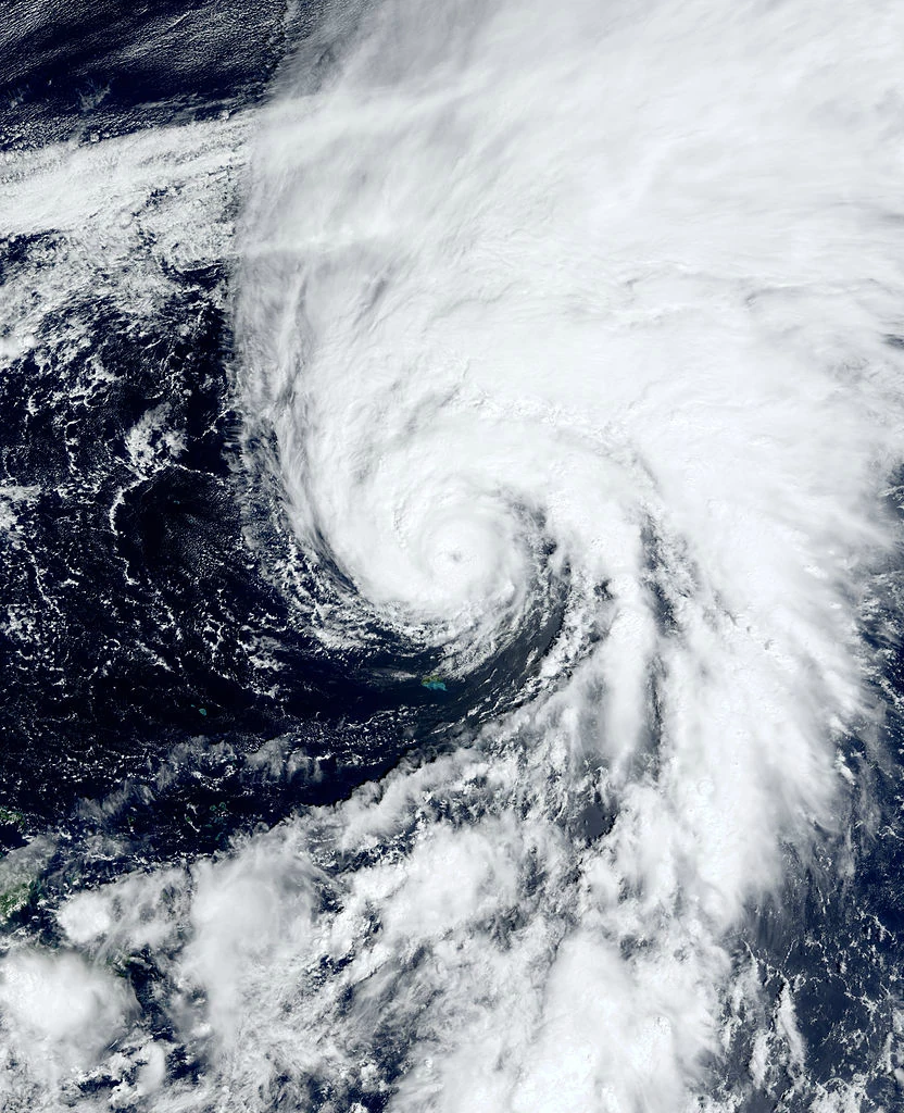
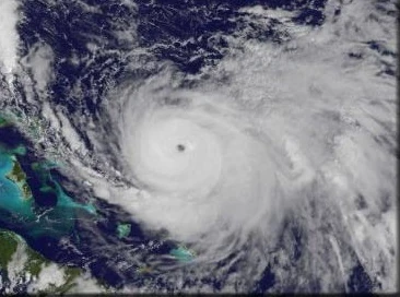
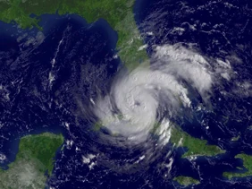
There were four category five hurricanes; Ethan, Jody, Renee, and Tara. Ethan overall had 165 mile per hour winds and a minimum pressure of 899 millibars; as it made landfall in Georgia at peak intensity. Jody had 195 mile per hour winds and a minimum pressure of 877 millibars, becoming the most intense hurricane ever to remain in the Atlantic basin as it had a similar track to Sandy and Irene combined, but making landfall on Washington D.C. directly. Renee was the third category 5 with winds of 175 miles per hour and a minimum pressure of 894 millibars as it remained out to sea, briefly brushing Bermuda with outer bands. Tara was the last category 5 and the second strongest, with winds of 185 miles per hour recorded in the center, and a minimum pressure of 884 millibars and made landfall directly at Louisiana and Mississippi, causing major damage.
It also features the longest lived hurricane on record; Hurricane Faye, peaking at category 1 intensity, lived for 34 days meandering over the Atlantic until it finally made landfall in Maine at peak intensity.
Season Summary[]
June[]
The season started off with five depressions forming in June, with Allen forming first on June 2.
Allen would peak at 70 miles per hour near the Azores before making landfall there and causing only $3.3 million dollars in damage. Bailey then formed the day after Allen did, peaking as a category 2 hurricane with 110 mile per hour winds, the first of the season. Bailey stayed out to sea the entire time but briefly affected Bermuda with the outer wind bands, causing less than $5,000 in damages. Carlos then formed on June 7, affecting the Bahamas and Florida as a mid-end tropical storm, and was the first name to be retired of the season. Then, on June 10, Hurricane Delilah formed, as the first major hurricane of the season, peaking with 150 miles per hour as it stayed out to sea for its entire lifetime, and was the first Cape-Verde type hurricane of the season, as it caused $3 billion in damages due to Oasis of the Seas going in.
Activity rapidly ceased after Delilah dissipated on June 19, and no tropical activity was monitored until June 27, where a wave rapidly developed into Hurricane Ethan, a low end category 5 hurricane, the second major hurricane of the season as it made landfall in southern Georgia at peak intensity, causing massive damages.
July[]
Five more storms formed in July. Activity once again ceased due to Ethan being active, until July 4.
Faye formed on July 4, and becoming the longest lasting hurricane in the world, as it lasted throughout several other storms, from Alissa to Jody. Alissa was one of the other two typhoons to cross over (The other one was Mabel) and peaked as a category 4 before making landfall in Louisiana. Gary then formed on July 11 and peaked as a category 3 major hurricane as it made landfall in Bermuda.
Once again, activity rapidly ceased until July 23, where Tropical Storm Hope formed, causing minor damages in the Bahamas. Ivan formed from a small thunderstorm line from Hope, peaking as a weak tropical storm as it made landfall in the Dominican Republic/Turks and Caicos, causing minor damages. Then, July ended with no other storms forming.
August[]
There were six storms that formed in August.
The season started off with Jody, the strongest storm of the season, a powerful category 5 hurricane that made landfall in Washington D.C. directly, causing catastrophic damages as it caused over 10,000 fatalities and over 300 billion in damage. Then, Tropical Depression Twelve formed and made landfall in North Carolina, causing minor damages. Tropical Depression Thirteen then formed, causing slightly more damage than Twelve. Then, twin hurricanes Kenneth and Layla forming, Kenneth being the stronger one. Kenneth looked more like an extratropical storm as it made landfall in the Gulf, causing nearly 700 million dollars and damage, while Layla stayed out to sea and made landfall in the Gulf of St. Lawrence at peak intensity. Then, Martin formed on August 24 and dissipated on August 29, remaining as a mid-end tropical storm, as it made landfall in Texas and brought much needed rain to California, which ended the storms in August.
September[]
There were four storms that formed in September.
Nora would stay from September 1 to September 7, peaking as a weak tropical storm, remaining out to sea. After Nora dissipated, activity once again rapidly ceased until September 19, where Hurricane Owen, a category 1 at peak intensity, formed, and went through the Gulf of Mexico but never made landfall, except briefly in Cuba. Meanwhile, Philippe formed, being the northernmost major hurricane on record in the Atlantic. Quentin formed and was an extremely small storm that made it at major hurricane intensity, making landfall at NYC at peak intensity. No other storms formed in September.
October[]
There were eight storms that formed in October.
Hurricane Renee formed and peaked as a mid end category 5, not affecting any land mass except for Bermuda with outer rain bands; it also caused two fujiwharas, one with an extratropical cyclone and one with the future Hurricane Sam later in the month. Tropical Depression Twenty Two formed and formed unusually south, missing Cape Verde and areas around the Gulf of Guinea with outer bands. Tropical Depression Twenty Three formed
Post Season Forecasts[]
On January 17, the NHC sent in that there would be around 20-30 depressions, 19-20 tropical storms, 15-16 hurricanes and 10 major hurricanes. Overall, they were pretty close, with the amount going to 40 depressions, 31 tropical storms, 19 hurricanes (2 typhoons) and 13 major hurricanes. Due to the El Nino rapidly weakening at around mid-April, warm waters were back in the Atlantic by mid-May, as waters soared above regular temperatures, hinting hypercanes were possible but luckily none happened. Meanwhile, the KMC broadcasted 35-40 depressions, 28-30 storms, 15-16 hurricanes and 10 major hurricanes; and they were even closer than the NHC, with 40 depressions forming, 31 storms, 19 hurricanes and two typhoons, and 13 major hurricanes.
The criteria for retirement this year was either getting over 500 deaths or over $1 billion dollars in damage.
Timeline[]

Storms[]
Tropical Storm Allen[]
| Tropical storm (SSHWS) | |
 | |
| Duration | June 2 – June 6 |
|---|---|
| Peak intensity | 70 mph (110 km/h) (1-min) 990 mbar (hPa) |
On May 30, the NHC noted that an extratropical cyclone about 200 miles north of Hispaniola might be possible for possible subtropical or tropical cyclogenesis. On May 31, the structure then began to rapidly reform, signaling a possible depression as it began to slowly organize, going north. On June 1, the depression was nearly declared as wind speeds of 20 miles per hour were recorded near the center after a recon flight at around 11:45PM; it was officially declared Subtropical Depression One at 5AM on June 2, as it began moving northeast, going over warm waters near the Azores, rapidly strengthening to Subtropical Storm Allen with 60 mile per hour winds by late June 2. On June 3, it began to move north, making landfall with 65 mile per hour winds, and up to 80 mile per hour wind gusts, causing power outages and moderate damage to the islands. On June 4, it began to move southeast, leaving the Azores as it strengthened to its peak of 70 mile per hour winds and 990 millibars as the structure remained extremely organized, as scientists thought it would peak as a category 1 briefly before rapidly weakening. On June 5, it made landfall in Bermuda surprisingly, rapidly disorganizing and causing heavy damage to the island. On June 6, it became an extratropical cyclone, causing minor damage to the UK later in the week. Allen did overall $3.3 million in damages, it wasn't retired however due to no fatalities reported and the minor impact.
Hurricane Bailey[]
| Category 2 hurricane (SSHWS) | |
 | |
| Duration | June 3 – June 9 |
|---|---|
| Peak intensity | 110 mph (175 km/h) (1-min) 973 mbar (hPa) |
On June 2, a tropical wave developed to the north of Cape Verde, remaining undeveloped until mid-day in June 3, when it became Tropical Depression Two as the organization and circulation continued developing, going towards a westernly track as it strengthened over time, until late that night it was up to 70 miles per hour, becoming Tropical Storm Bailey, with a minimum pressure of 993 millibars as it began to rapidly intensify, by 7AM EST on June 4, it became Hurricane Bailey, packing 85 miles per hour in the center and a minimum pressure of 981 millibars as it began to move faster, nearing the warm waters. On June 5, it intensified to peak intensity of 110 miles per hour, with a minimum pressure of 973 millibars as it neared the Bahamas. On June 6, it remained at peak intensity as it began to rapidly go up north. On June 7, encountering cold waters, it began to weaken as the system now had 90 mile per hour winds, weakening down to a category 1 hurricane as it brushed Bermuda with light rain showers; no damage was reported except for a heavy wind gust that blew down a few shingles on a roof; costing a mere $1000 in damage. On June 8, it became a tropical storm as the structure began to rapidly detrioriate; nearing Nova Scotia. On June 9, it dissipated about 300 miles before reaching Nova Scotia, not becoming an extratropical cyclone. Bailey only caused $1000 in damages and did not make landfall anywhere; however, one fatality was reported near Bermuda, but Bailey wasn't retired.
Tropical Storm Carlos[]
| Tropical storm (SSHWS) | |
 | |
| Duration | June 7 – June 12 |
|---|---|
| Peak intensity | 55 mph (90 km/h) (1-min) 998 mbar (hPa) |
On June 7, the NHC decided to monitor a strong tropical wave in the middle of the Atlantic. Of course, later that night, it began to get organized, declaring it Tropical Depression Three as it began to move west, as the storm began to get more organized. Tropical Storm Carlos is known due to it's unusually large eye and small size. On June 8, the storm became Subtropical Storm Carlos with 45 miles per hour winds, as it neared the warm waters of the Caribbean, turning tropical and gaining winds of up to 50 miles per hour as it started to show an extremely large eye as it neared the Bahamas and Florida. On June 9, it slammed into the Bahamas, using Brown Ocean Effect to remain organized and strengthening to its peak of 55 miles per hour as it then made landfall in Florida, still using Brown Ocean Effect to stay. On June 10, it had 50 miles per hour winds as the structure remained extremely organized, as it meandered in the Gulf, it slowly got disorganized, losing the eye by early June 11, the outer bands by mid-day June 11, and it finally degenerated into a remnant low early morning of June 12. Carlos overall caused $8.5 million damages, $3.2 million in the Bahamas and $5.3 million in Florida. Carlos also caused four fatalities. Due to this, and because of the effects it had in Florida (The State of Florida requested to retire the name) Carlos was retired and replaced with Cameron.
Hurricane Delilah[]
| Category 4 hurricane (SSHWS) | |
 | |
| Duration | June 10 – June 19 |
|---|---|
| Peak intensity | 150 mph (240 km/h) (1-min) 926 mbar (hPa) |
On June 9, the NHC decided to monitor a tropical wave south of Cape Verde, traveling northeast. Late June 10, it became Tropical Depression Four, packing 35 miles per hour in the center of the storm as convection increased in the center, becoming Tropical Storm Delilah by mid-day June 11. It began to move up north towards the Canary Islands and Spain; rapidly strengthening to Hurricane Delilah with 85 mile per hour winds by June 12, before entering warm waters near Spain and rapidly intensifying to a category 3 hurricane by early June 13; with winds now at 125 miles per hour as it neared landfall in Spain and Portugal. On June 14, it strengthened to category 4 with 150 miles per hour winds as it made landfall in Portugal; once again using Brown Ocean Effect to strengthen over land; a peak of 155 miles per hour was estimated but was never recorded, as it went out again into the Atlantic, rapidly weakening on June 15 to a category 2 with 100 miles per hour winds as it meandered then in the Atlantic; not making landfall however it encountered Oasis of the Seas on the journey; nearly capsizing it as it strengthened once more to 115 miles per hour, becoming a category 3 on June 16 as Oasis of the Seas was nearly sunk; however the winds just tipped it heavily; damage from it costed at an extremely high rate of $2 billion due to the expensive ship. On June 17, it stalled as a bunch of troughs kept it from entering warm waters, slowly weakening to a category 2 by mid-day on June 17, and by June 18 it was only a category 1. It then started to move very slowly once more, the structure rapidly deteoriorting before dissipating sometime around June 19. Delilah caused fourteen fatalities and caused $2.7 billion in damages. Therefore, Delilah was retired and replaced with Dora.
Hurricane Ethan[]
| Category 5 hurricane (SSHWS) | |
 | |
| Duration | June 27 – July 11 |
|---|---|
| Peak intensity | 165 mph (270 km/h) (1-min) 899 mbar (hPa) |
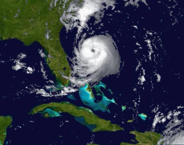
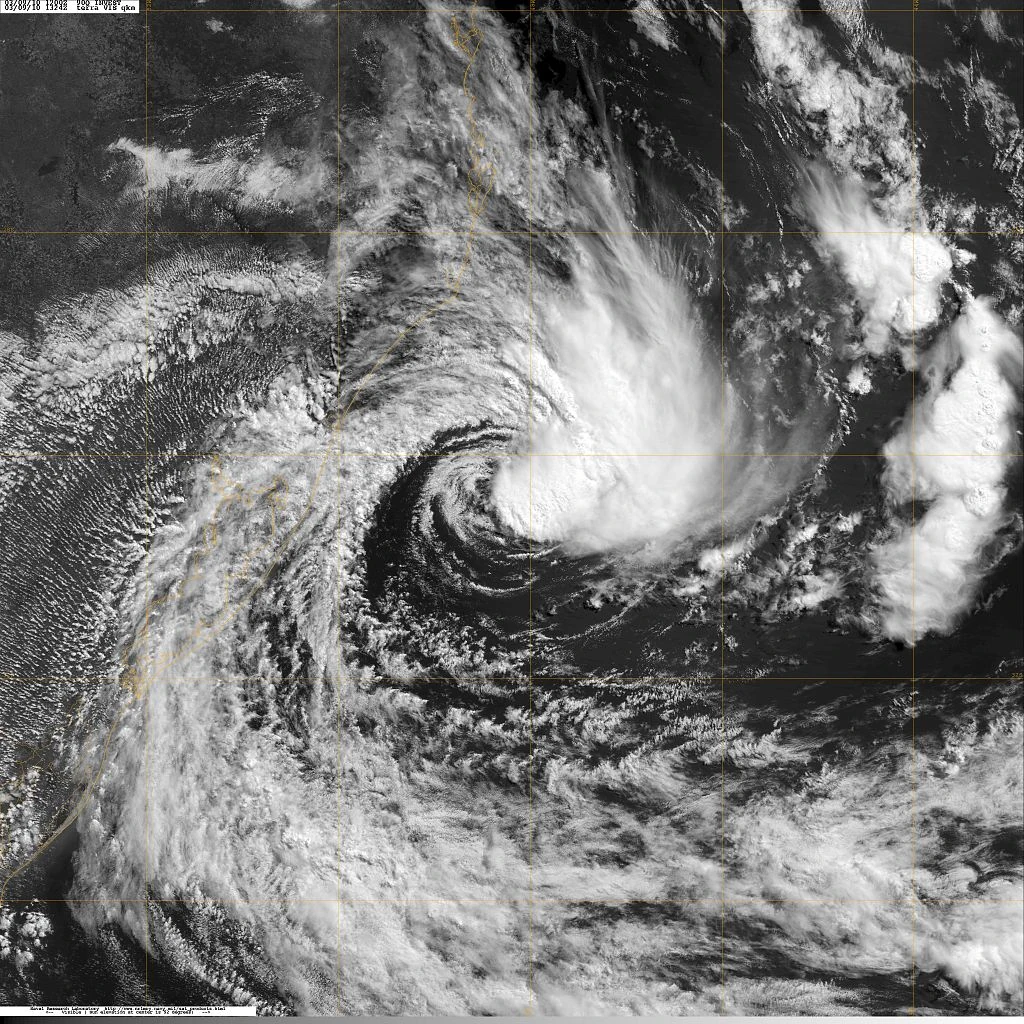
On June 27, the NHC noted an area of interest near Bermuda as it began to show convection near the center. It then passed by Bermuda, bringing strong winds and light showers as it began to rapidly strengthen; becoming Tropical Depression Five as it moved out of Bermuda, quickly strengthening to Tropical Storm Ethan with 40 mile per hour winds as it began to move southwards towards Georgia slowly. On June 28, it strengthened once more to 70 miles per hour, becoming a strong tropical storm as it began to go entirely south; causing a ship called the RMS Ocean Star to go in, as the ship was battled with 75 mile per hour gusts according to them; becoming Hurricane Ethan late June 28 as it began to rapidly strengthen up to 100 miles per hour, becoming a category 2 as RMS Ocean Star once again managed to get out with heavy damage; Ocean Star was immediately brought back to the port of Havana to go under extensive repairs. On June 29, it weakened down to a category 1 once more as it entered cold waters, before entering warm waters once again and strengthening to a category 3 hurricane with 115 mile per hour winds, briefly nearing the Dominican Republic before turning northwest towards Georgia. On June 30, it then began to stall, rapidly growing in size to a category 4 with 150 mile per hour winds. On July 1, it weakened down to a category 3 again as it began to slowly move towards Georgia. On July 2, it then began to stall as it weakened to a category 2. On July 3, it then strengthened back to a category 4 hurricane with 155 mile per hour winds as it began to move once more towards Georgia. On July 4, it neared landfall as it became a category 5 with 165 mile per hour winds, the first of the season. On July 5, it made landfall at peak intensity, causing major damages and heavy floods and rapidly weakening to a category 4. On July 6, it then went out to sea and weakened to a category 2. On July 7, it strengthened again to a category 3. On July 7, it strengthened to a category 4 with a secondary peak of 155 miles per hour as it made landfall near the South Carolina border, before rapidly weakening. On July 8, it became Hurricane Ethan again with 80 mile per hour winds, before rapidly weakening. On July 9, it stayed inland. On July 10, using Brown Ocean Effect, it strengthened to a category 2 near Sugar Hill, Georgia. On July 10, it rapidly weakened as it stalled over Sugar Hill. On July 11, it finally dissipated. Ethan caused $3 billion in damages and twenty fatalities; therefore Ethan was retired and replaced with Elmer.
Hurricane Faye[]
| Category 1 hurricane (SSHWS) | |
 | |
| Duration | July 4 – August 7 |
|---|---|
| Peak intensity | 95 mph (155 km/h) (1-min) 949 mbar (hPa) |
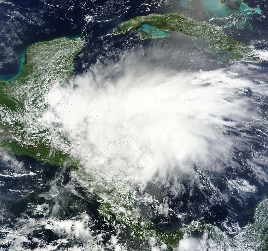
On July 3, the NHC noted that a tropical wave exiting from Cape Verde would possibly become a major hurricane. On July 4, it became Tropical Depression Six, with 35 mile per hour winds as it exited Cape Verde, intended to strengthen to a mid-end category 5 status. On July 5, it strengthened to Tropical Storm Faye with 60 mile per hour winds before rapidly strengthening to 80 miles per hour, becoming Hurricane Faye as it began moving towards the US, the pressure rapidly dropping from 989 millibars to 975 millibars as it intensified to 90 miles per hour, moving slowly towards the U.S. On July 6, it then stalled in the Atlantic, growing in size, as it eerily resembled Hurricane Floyd of 1999. On July 7, it still stalled as winds went up to 95 miles per hour as an eye began to show. On July 8, it remained at intensity as it neared landfall; however it actually never did and went through the passage between the Bahamas and Florida, as outer bands affected the Bahamas and Florida. On July 9, it moved out and moved towards the ocean. Nothing much happened from July 9 to August 1, except for the fact that the pressure rapidly deepened to a pressure of 949 millibars, more characteristic of a category 3 or 4 hurricane than a category 1 hurricane, and the fact that it only moved east, until August 1, where it began to loop and move towards the west. On August 2, it finally began to show signs of weakening as the structure began to rapidly deteriorate. On August 3, it weakened to 80 miles per hour as the eye began to become clouded. On August 4, it began to move towards America again. On August 5, it weakened down to 75 miles per hour and remained at this intensity, until making landfall on August 6 in New Jersey, causing moderate damages before rapidly weakening and dissipating on August 7. Faye only caused $323 million in damage and three fatalities; therefore Faye was not retired.
Hurricane/Typhoon Alissa[]
| Category 4 hurricane (SSHWS) | |
 | |
| Duration | July 6 (entered) – July 16 |
|---|---|
| Peak intensity | 140 mph (220 km/h) (1-min) 939 mbar (hPa) |
Not much was documented on this hurricane. On July 6, the weak remnants of Typhoon Alissa entered the Atlantic, before reorganizing itself later that day and becoming Tropical Storm Alissa with 50 mile per hour winds as it exited the Mexican Coast. On July 7, it strengthened to 70 miles per hour as it unexpectedly turned subtropical, becoming Subtropical Storm Alissa before quickly becoming tropical once entering the warm waters near Cuba, intensifying to 75 miles per hour, becoming Hurricane Alissa as it went and made landfall in Cuba, rapidly weakening on July 8. On July 9, it went up from Cuba, strengthening to category 2 intensity with 100 mile per hour winds as it neared Bermuda. On July 10, it intensified rapidly to 125 miles per hour as it brushed Bermuda with outer rain bands. On July 11, it began to loop and go south; before rapidly accelerating barely below Florida. On July 12, it neared landfall in Louisiana as it grew to an extremely large size. On July 13, it made landfall at peak intensity of 140 miles per hour as it rapidly weakened over land. On July 14, it still remained as a high end category 1 hurricane. On July 15, it rapidly accelerated to the northeast. On July 16, it rapidly weakened and dissipated as a depression over Missouri. Alissa caused surprisingly minor damage despite the landfall; and one fatality, therefore Alissa wasn't retired.
Hurricane Gary[]
| Category 3 hurricane (SSHWS) | |
 | |
| Duration | July 11 – July 19 |
|---|---|
| Peak intensity | 115 mph (185 km/h) (1-min) 954 mbar (hPa) |
On July 11, an area about 300 miles to the northeast of Alissa was declared a tropical disturbance at 3PM, and remained a tropical disturbance until about seven hours later at 10PM, becoming Tropical Depression Eight (Alissa was the seventh depression) and strengthening to 35 miles per hour. On July 12, it strengthened to Tropical Storm Gary with 55 mile per hour before rapidly strengthening once more with 75 miles per hour in the center, becoming Hurricane Gary at category 1 intensity early on July 13, going near a track towards Bermuda, strengthening to 90 miles per hour by late July 13. On July 14, it rapidly strengthened to 110 miles per hour as a large greek naval ship, the SS Helios, went into the storm, as people onboard the ship reported gusting winds and heavy rainfall as it strengthened to 115 miles per hour, becoming a category 3 hurricane on the scale, peaking at 115 miles per hour before rapidly weakening on July 15, before managing to pulling itself together and reaching a secondary peak of 105 miles per hour as it made landfall in Bermuda, causing major power outages, heavy wind gusts and lots of rain, causing major flooding on the island as the structure began to slowly get disorganized; going down to 95 miles per hour by only three hours later as it stalled over Bermuda until July 16, where it weakened to 80 miles per hour as it began to slowly move southeast, towards Puerto Rico. On July 17, it weakened down to 60 miles per hour, becoming Tropical Storm Gary once more, before strengthening to 90 miles per hour once more. On July 18, it reached a third intensity of 95 miles per hour as it then became rapidly disorganized; becoming a weak tropical storm until July 19, where it became 50 miles per hour before rapidly weakening and dissipating at mid-day on July 19. Gary was the worst hurricane to hit Bermuda since Arlene; Gary was retired and replaced with Gerald. Gary caused $873 million in damages and an estimate of 587 fatalities on the island.
Tropical Storm Hope[]
| Tropical storm (SSHWS) | |
 | |
| Duration | July 23 – July 31 |
|---|---|
| Peak intensity | 70 mph (110 km/h) (1-min) 991 mbar (hPa) |
On July 23, Hurricane Gary's remnants went into the Gulf of Mexico, where convection developed near the center, as it began to bring 20 to 25 mile per hour winds as the structure improved. Later that day on July 23, the low was upgraded to Tropical Depression Nine; and began to move out of the Gulf of Mexico, remaining as a strong tropical depression before briefly making landfall on the Yucatan peninsula; rapidly weakening down to 15 miles per hour as it nearly dissipated; however it entered warm waters again on July 24, and strengthened to Tropical Storm Hope with 40 mile per hour winds as it weakened down to Tropical Depression Nine again. On July 25, it reintensified with a new peak of 50 miles per hour as it became Tropical Storm Hope again, as it went through the Glass Window Bridge without any problems, only causing minor storm surge but extremely large wind gusts. On July 26, they decided to go into a recon flight into Hope, and found wind speeds of approximately 70.4 miles per hour in the center, upgrading it to a strong tropical storm as it went out into the Atlantic. On July 27, it weakened down to 65 miles per hour as the structure began to slowly deteoriate; going up northeast. On July 28, it remained as a weak tropical storm nearing Nova Scotia and Newfoundland. On July 29, the storm weakened to a depression. On July 30, after one last time as a tropical storm of 45 miles per hour, it made landfall around the area of the Gulf of St. Lawrence as a weak tropical storm, bringing minor damages. On July 31, it finally dissipated near the edge of the gulf. Hope caused $10 million in damage and no deaths, therefore Hope wasn't retired.
Tropical Storm Ivan[]
| Tropical storm (SSHWS) | |
 | |
| Duration | July 29 – August 3 |
|---|---|
| Peak intensity | 40 mph (65 km/h) (1-min) 998 mbar (hPa) |
On July 27, a weak line of thunderstorms broke off of Hope, going to the southeast, before starting to get organized on July 28, as convection and winds in the center increased, as it was classified as a disturbance and an invest. On July 29, it strengthened to Tropical Depression Ten as it began to get more organized as it posed no threat to any landmass. By July 30, it strengthened to Tropical Storm Ivan with 40 mile per hour winds, where it would stay at peak intensity. By July 31, it then began to move southwest, as it slowly neared the Dominican Republic. On August 1, it weakened down to a tropical depression, but regained tropical storm status later in the day, because of warm waters, as it made landfall in the Dominican Republic/Turks and Caicos, but no impacts were caused except for isolated power outages and large wind gusts, with heavy rain being reported as much as six inches; it was responsible for partially collapsing the Beaches Turks and Caicos, specifically the Italian Village. On August 2, it rapidly weakened as it stalled over the landmass, and began to go west. On August 3, it finally dissipated after the high altitude mountains of the Dominican Republic teared it up. Ivan caused $27 million and one fatality, therefore Ivan wasn't retired.
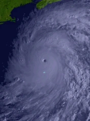
Hurricane Jody[]
| Category 5 hurricane (SSHWS) | |
 | |
| Duration | August 5 – August 24 |
|---|---|
| Peak intensity | 195 mph (315 km/h) (1-min) 877 mbar (hPa) |
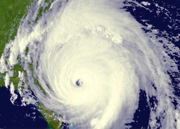
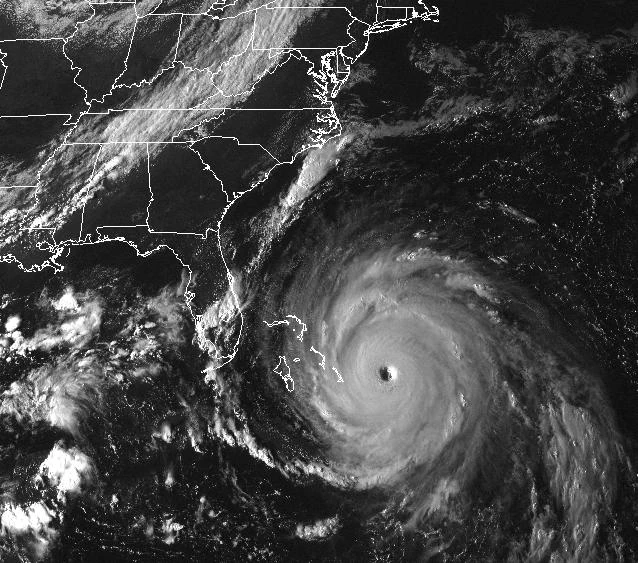
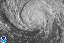
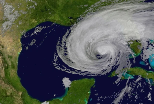
On August 5, the remnants of Tropical Storm Ivan began to get organized in nearly the same exact spot that Irene of 2011 spawned. It then became Tropical Depression Eleven, and began to move to the east. On August 6, it became Tropical Storm Jody, as it nearly made landfall in the Lesser Antilles. However, it gained 65 mile per hour winds as it began to strengthen where Sandy once formed. Jody would then strengthen to a category 1 hurricane on August 7 as it began to follow the same exact track Sandy and Irene would follow along the coast. On August 8, it began to follow the track as it strengthened to a category 2 as it exited near Cuba. On August 9, it moved out, where strong troughs began to push it in place, prohibiting it to move; however, it did grow in size to about 1,200 miles, with winds increasing from 70 miles per hour to 155 miles per hour by August 13, however it strangely never showed an eye. On August 14, it increased wind speeds to 159.5 miles per hour according to a recon flight. On August 15, it intensified to the second category 5 of the season, and attained winds of 170 miles per hour as the pressure went down to 894 millibars. On August 16, it began to follow the track of Sandy, briefly making landfall in the Bahamas and accelerating up at about 12 miles per hour. On August 17, after showing landfall at peak intensity, President Obama forced mandatory evacuations from Washington D.C. and any surrounding landmass to avoid getting hit by Hurricane Jody. On August 17, it neared the Bay of Chesapeake, but several models forecast it making landfall in New Jersey, some in Washington D.C. It gained winds of 185 miles per hour and the pressure deepened down to 889 millibars as it began to enter the Bay of Chesapeake, briefly making landfall in Virginia at 180 miles per hour and Maryland/Delaware at 185 miles per hour, however it neared Washington D.C. On August 18, it reached peak intensity of 195 miles per hour and 877 millibars it began to cross over lands, causing catastrophic damage to Washington D.C, with 210 mile per hour gusts recorded as a large EF4 tornado touched down, causing more catastrophic damage as remaining Washington D.C. residents were killed or injured critically by the hurricane or tornado. On August 18, it stalled over Washington D.C, still bringing gusts of 195 miles per hour and wind speeds of 175 miles per hour. On August 19, it deintensified and moved across land, becoming a category 3 as it briefly made landfall in New York City, bringing similar affects of Sandy and Irene combined, before moving out to sea. On August 20, as it entered cooler waters, it became a tropical storm with 60 mile per hour winds as it began to follow a similar track to Faith now. On August 21, it began to move over the UK as a minor wind storm, with gusts being recorded at 80 miles per hour at peak intensity. On August 22, it neared Norway as it was reclassified as a category 1 hurricane, becoming the northernmost hurricane and being intensified at the farthest north latitude. On August 23, it avoided Norway and moved up, where it was then in contact with a large ice mass. On August 24, it finally deintensified rapidly and dissipated. Jody caused $346 billion, being the most costliest hurricane, and caused over 15,000 fatalities all around America, therefore Jody was retired and was never to be used again.
Tropical Depression Twelve[]
| Tropical depression (SSHWS) | |
 | |
| Duration | August 10 – August 12 |
|---|---|
| Peak intensity | 25 mph (35 km/h) (1-min) 1002 mbar (hPa) |
On August 10, a low near the Bahamas began to show some convection as the system began to get more organized. The system began to go over the Bahamas, bringing light rain showers and gusts of 30 to 40 miles per hour as no damage was caused, as it moved over and reached peak winds of 25 miles per hour as the outer bands barely hit Florida, as the disturbance was then identified as Tropical Depression Twelve with 25 mile per hour winds as it struggled to strengthen beyond Tropical Depression status, with the depression reaching the peak of 1002 millibars. On August 11, it remained as a tropical depression as it moved northwest, weakening down to 20 miles per hour briefly before reaching another peak of 25 miles per hour and 1003 millibars as it made landfall in North Carolina as a weak depression, causing less than $10,000 in damage as it battered North Carolina with only heavy rain, with local flooding occurring mainly on the coast of North Carolina. On August 12, the depression rapidly weakened over land and managed to move over the rugged mountains of North Carolina, before being teared up and dissipating near Asheville. Twelve caused an estimate of $3,000 in damage and two fatalities due to flooding.
Tropical Depression Thirteen[]
| Tropical depression (SSHWS) | |
 | |
| Duration | August 14 – August 19 |
|---|---|
| Peak intensity | 30 mph (45 km/h) (1-min) 1001 mbar (hPa) |
On August 14, the weak remnants of Tropical Depression Twelve moved out into the Atlantic, and began to get reorganized as it entered warm waters near Jamaica, becoming Tropical Depression Thirteen late that day as it began to get more organized and show more convection near the center as it began to move towards the Lesser Antilles near South America, as known as the ABC Islands. It neared landfall but unexpectedly looped extremely slowly. On August 15, it stalled near there, growing about 10 miles in size. On August 16, it started to move towards the Yucatan Peninsula as it reached a peak of 30 miles per hour and a minimum pressure of 1001 millibars as it began to increase in size slowly as it moved towards the Yucatan Peninsula. On August 17, it weakened to 1002 millibars before it briefly made landfall in Jamaica, causing heavy rain but practically no wind at all, and a few trees collapsed due to flooding. On August 18, it moved towards the Yucatan, making landfall on the tip as it brought heavy rain and around $50,000 in damages. On August 19, it rapidly weakened as it went inland and dissipated. Thirteen caused $50,000 in damages and two fatalities.
Hurricane Kenneth[]
| Category 2 hurricane (SSHWS) | |
 | |
| Duration | August 18 – August 22 |
|---|---|
| Peak intensity | 100 mph (155 km/h) (1-min) 980 mbar (hPa) |
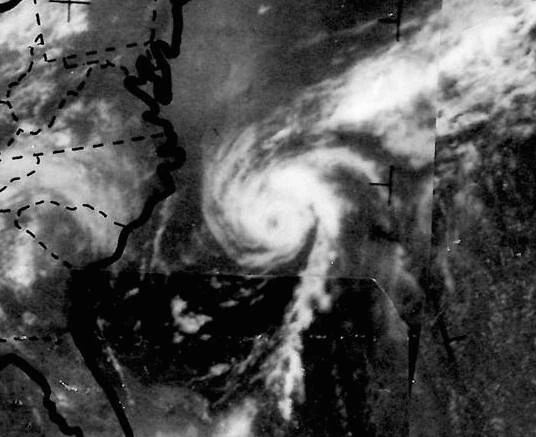
On August 18, a low began to get organized and show frontal features as it exited off the coast of Mexico, and early on August 19, it was declared Tropical Depression Fourteen as it began to move up northwest slowly towards the Gulf of Mexico. On August 20, it was found with 70 mile per hour winds in the core, strengthening it to Tropical Storm Kenneth as it entered the warm waters of the Gulf of Mexico, strengthening to Hurricane Kenneth late August 20, as it began to show signs of intensifying, including showing an extremely large eye, however it had an extremely similar structure to a storm that was extratropical as it neared Louisiana on August 21, where it reached peak intensity of 100 miles per hour and a pressure of 980 millibars as it began to turn northeast, missing Cuba by barely but affecting it with heavy rain, high wind gusts and isolated power outages, and causing $200 million in damages as it began to turn northwest towards Louisiana, as it began to show signs of turning extratropical including a deintensifying structure and the eye becoming clouded. On August 22, it began to turn tropical again with winds of 80 miles per hour as it made landfall at Louisiana at the secondary peak intensity, causing $493 million in damages as it caused heavy flooding and managed to break two levees in New Orleans, causing minor flooding. Overall, Kenneth caused $693 million and 25 fatalities, and Kenneth was retired and replaced with Keith.
Hurricane Layla[]
| Category 1 hurricane (SSHWS) | |
 | |
| Duration | August 18 – August 22 |
|---|---|
| Peak intensity | 95 mph (155 km/h) (1-min) 984 mbar (hPa) |
On August 18, only hours after Kenneth formed, a depression rapidly formed off the coast of Florida as it began to get organized rapidly, becoming Tropical Storm Layla by August 19, with 50 mile per hour winds as it began to turn eastwards off the coast, brushing Bermuda with bands of rain as it caused heavy flooding of island as a 8 foot storm surge flooded about 15% of the island, causing Kings Wharf and several other towns to be under Flash Flood Warnings as it brought wind gusts of up to 70 miles per hour on the island. Late on August 19, they sent in a recon flight and they came out with results of 83.4 mile per hour winds in the core, causing Layla to be upgraded to a hurricane as the pressure deepened down to 990 millibars. On August 20, it began to move up the coast still, nearing Newfoundland as a strong category 1 hurricane. Another recon flight on August 20 in the middle of the day upgraded it to a strong category 1 hurricane, with 89.9 mile per hour winds in the center, as it became an extremely strong category 1 hurricane as the pressure deepened down to 986 millibars, near peak intensity. On August 21, Hurricane Warnings were in place for the Newfoundland Area, while Hurricane Watches were placed near Nova Scotia and areas near Newfoundland, and Tropical Storm Warnings for areas more inland. On August 22, it reached peak intensity of 95 miles per hour and a pressure of 984 millibars as it made landfall in Nova Scotia at peak intensity, causing moderate damage, before going inland but growing in size, causing heavy flooding everywhere, killing 498 people surprisingly due to the fact that they were unprepared. Late August 22, it rapidly weakened and as it was nearly 12AM on August 23, it dissipated finally. Layla caused $400 million and damage and 498 fatalities, therefore Layla was retired and replaced with Lara.
Tropical Storm Martin[]
| Tropical storm (SSHWS) | |
 | |
| Duration | August 24 – August 29 |
|---|---|
| Peak intensity | 65 mph (100 km/h) (1-min) 989 mbar (hPa) |
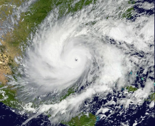
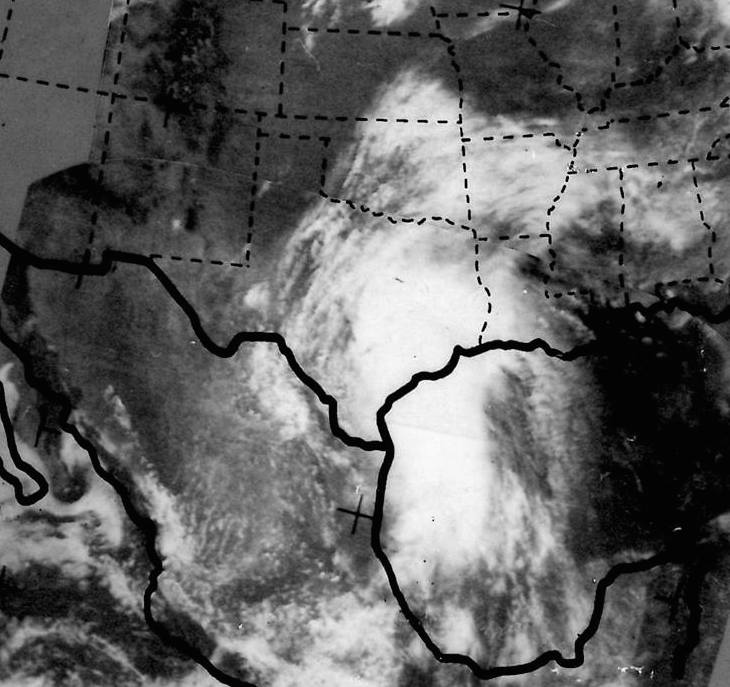
On August 23, an extremely weak tropical wave exited Cape Verde and entered the Gulf of Mexico, where the weak remnants of Layla moved down to the Gulf of Mexico, combining and showing some convection as the disturbance became Tropical Depression Sixteen on August 24, as it began to move towards Texas, with 35 mile per hour winds as it moved towards Texas still. On August 25, it strengthened to Tropical Storm Martin with 45 mile per hour winds as it began to move faster towards Texas, growing in size but still not showing an eye. It bursted in convection again, briefly touching the Yucatan Peninsula as a weak tropical storm, with rain and heavy winds as the only ones, before going towards Texas once more, as the convection brought it up to 60 miles per hour as it still increased in size, eventually becoming the same exact size as Tropical Storm Candy in 1968. On August 26, it decreased in convection, still with the same size but weakening down to 50 miles per hour before reaching a new peak of 65 miles per hour and a pressure of 989 millibars, making landfall in Texas at peak intensity. On August 27, it still remained over land as a weak depression, as it traveled across, bringing high winds and heavy rain, with local flooding being reported in at least several states in the southwest. On August 28, the depression hit California, being one of the only depressions to ever hit, which caused the most damage, bringing much needed rain and and drowning the drought that affected it by 68%, bringing the drought down to a weak drought. On August 29, it weakened over California and dissipated, before regenerating later that day to a depression, before dissipating at around 11PM on August 29, bringing the drought down to a total of 13%. Martin caused $978 million in damage and twenty seven fatalities, therefore Martin was retired and replaced with Mason.
Tropical Storm Nora[]
| Tropical storm (SSHWS) | |
 | |
| Duration | September 1 – September 7 |
|---|---|
| Peak intensity | 45 mph (75 km/h) (1-min) 994 mbar (hPa) |
On September 1, a tropical wave exited near Cape Verde, intended to become a major hurricane, but instead became Tropical Depression Seventeen later that day, as it began to follow a track similar to Cape Verde hurricanes. On September 2, it remained as a tropical depression as it briefly overturned a small rowboat full of survivors, killing one of them, out of the three people there on the rowboat, as it began to accelerate faster, at a rate of 10 miles per hour, as it began to turn up north, strengthening to Tropical Storm Nora by September 3, with 40 mile per hour winds before weakening to a depression again, before regaining tropical storm status by early September 5, and reaching a new peak of 45 miles per hour and a minimum pressure of 994 before accelerating up and causing a near capsize of a small cruise liner, the RMS Starlight, before overflowing it with water, not sinking it but causing heavy damage. On September 6, it weakened down to a depression as it began to grow in size, before having a burst in convection, before rapidly weakening and turning extratropical, later affecting the UK as a minor windstorm. Nora caused $200 million in damages and one fatality, therefore Nora was not retired.
Hurricane Owen[]
| Category 1 hurricane (SSHWS) | |
 | |
| Duration | September 19 – September 27 |
|---|---|
| Peak intensity | 75 mph (120 km/h) (1-min) 971 mbar (hPa) |
On September 19, nearly two weeks after Nora dissipated, a tropical wave exited the coast and followed a classic Cape-Verde track, strengthening to Tropical Depression Eighteen as it began to travel straight across, similar to Georges in 1998, except slightly more north. On September 20, it became Tropical Storm Owen with 40 mile per hour winds, before weakening down to a depression on September 20, as it began to enter warm waters near the Caribbean, tradewinds began to push Owen to the tiny passage between Florida and Cuba on September 21, strengthening to Tropical Storm Owen with 55 mile per hour winds, later strengthening to 70 miles per hour as it went through the passage. On September 22, it began to loop and circle around Cuba as it hit a peak intensity of 75 miles per hour and a pressure of 974 millibars before weakening to a storm again. On September 23, it remained as a storm as it passed through another passage, briefly making landfall at the tip of Cuba, causing downed trees, power outages and minor flooding. On September 24, it actually reached peak intensity, but wind shear as it began to exit the coast began to get to Owen, weakening it down to a strong tropical storm before exiting the Caribbean and going out into the Atlantic. On September 25, it strengthened to a category 1 hurricane again briefly, but wind shear from the rapidly intensifying Hurricane Philippe prohibited any further development after that. On September 26, it weakened down to a mid-end tropical storm, and then a low end tropical storm by late September 26. On September 27, it weakened down to a depression, before briefly peaking with 40mph before rapidly weakening and turning extratropical. Owen caused $134 million in damage and two fatalities, therefore Owen was not retired.
Hurricane Philippe[]
| Category 4 hurricane (SSHWS) | |
 | |
| Duration | September 24 – October 2 |
|---|---|
| Peak intensity | 155 mph (250 km/h) (1-min) 923 mbar (hPa) |
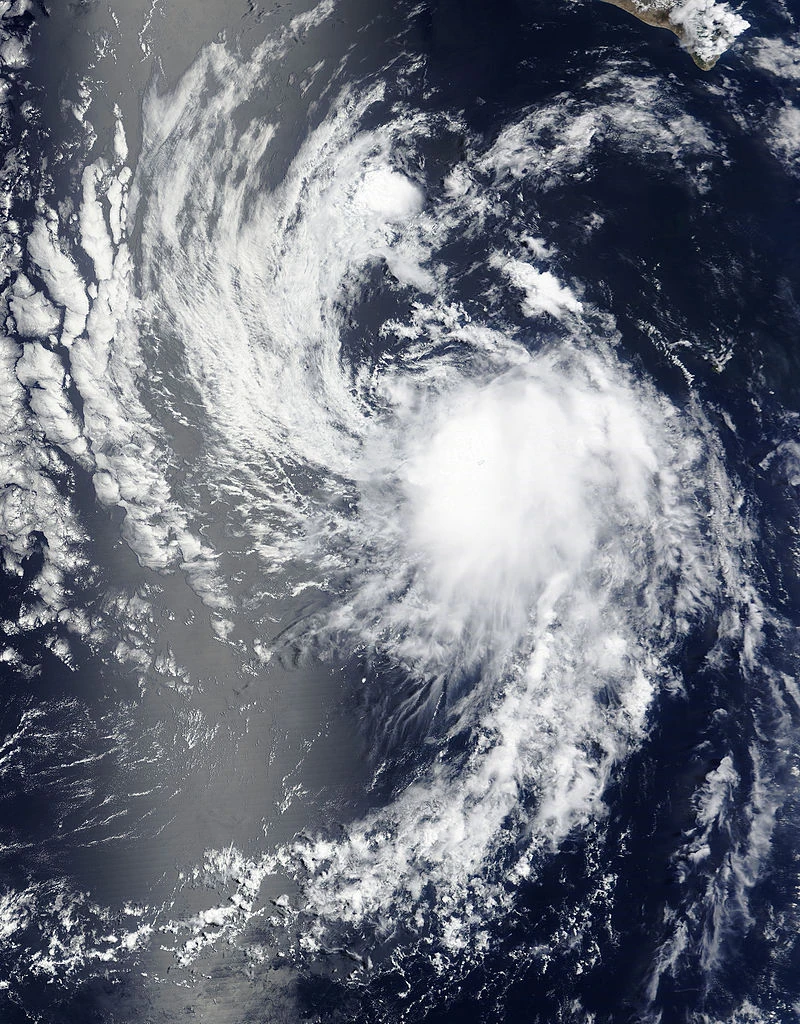
On September 24, an invest formed about 100 miles northeast of Owen, as wind shear surrounded the system, causing Owen to weaken to a tropical storm as the invest rapidly became Hurricane Philippe within nine hours of formation, with 75 mile per hour winds in the system as it began to go up northeast, forming near the southwest corner of Bermuda. It went over Bermuda as a category 1 hurricane, causing minor damages to the island as the island was still finishing up building from Hurricane Gary earlier in the season. On September 25, it passed over the island and went northwest, before turning up north north west, intensifying to a category 2 on September 26, about the same distance where Ellen was in 1973, before becoming a major hurricane at 48.6 degrees latitude, and weakening to a category 2 about three hours later. On September 27, it strengthened to a high end category 3 again at 51 degrees latitude, before strengthening to a high end category 4 on September 28. It began to accelerate at a rate of 36 miles per hour, becoming nearly the easternmost storm, before rapidly weakening took place on September 29 and dissipated nearly, before turning around as an extratropical cyclone, by now it was still classified as a tropical depression, but turned around and was classified as Tropical Storm Philippe once more, before turning subtropical and becoming Subtropical Philippe with 70 mile per hour winds. On September 30, it remained a subtropical storm, with winds estimated to be at 69.2 miles per hour. On October 1, it briefly became a category 1 hurricane for several hours before rapidly weakening once again took place. Philippe then weakened and dissipated on October 2. Philippe caused a minor $69 million in damages and caused one fatlity, therefore Philippe was not retired.
Hurricane Quentin[]
| Category 3 hurricane (SSHWS) | |
 | |
| Duration | September 26 – October 6 |
|---|---|
| Peak intensity | 125 mph (205 km/h) (1-min) 954 mbar (hPa) |
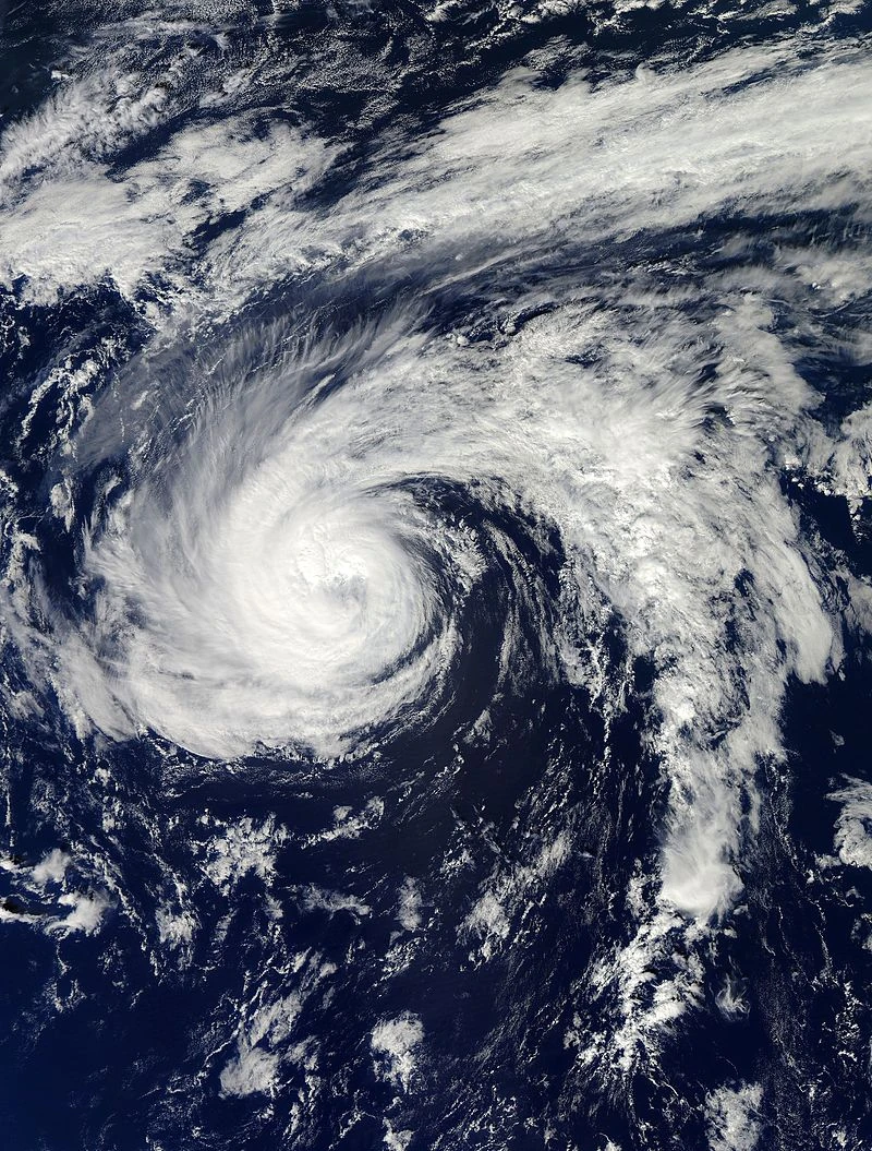
On September 26, a line of thunderstorms broke off of Philippe and began to move southwest, organizing and becoming Tropical Depression Twenty later that day because of showing a closed circulation, as it began to go near the Gulf of Mexico. On September 27, it became Tropical Storm Quentin with 60 mile per hour winds, going near Bermuda, as it briefly made landfall as the extremely small Tropical Storm Quentin, having an eerie resemblance to Hurricane Karl of 1980 as it began to move up northwest towards New England. On September 28, it briefly reached hurricane status of 80 miles per hour before weakening due to cold waters. It began to fluctuate in intensity on September 29 and 30, causing impacts in New England ranging from rain showers to thunderstorms with hail, with these impacts being extremely unknown, causing meteorologists being unable to predict whether a regular storm or an extremely bad rainstorm would come. On October 1, it finally reached hurricane intensity, as it began to rapidly intensify, going from a 85 mile per hour hurricane with 982 millibars to a category 2 with 110 mile per hour winds and a pressure of 969 millibars in approximately 7 hours. On October 2, it weakened down to a high end category 1 hurricane, before intensifying to a high end category 2 hurricane later that day as it went northwest near New York City. On October 3, it reached a secondary peak of 120 miles per hour and a minimum pressure of 958 millibars, before weakening down to a low end category 3. On October 4, it reached peak intensity just as it made landfall directly in Staten Island, New York City, causing catastrophic damages, and even a documented EF1 tornado that formed in Quentin. Despite the small size, it made big impacts on the city. Skyscrapers were blown clean of windows as damages were similar to Sandy, but worse. Quentin also caused two cranes to collapse, killing seven people overall as the system became a major cold core system, bringing heavy snow and blizzard like conditions to the southern part of the city, while snow showers on the eastern and northern part of the city. On October 5, it weakened to a category 1 hurricane as it made landfall in Connecticut, bringing downed trees, power outages and more, with a small EF0 being documented in the forest and one small waterspout. On October 6, it rapidly went inland and turned extratropical, bringing minor damages to New England and southern Quebec. Quentin caused $5.8 billion in damages and fourteen fatalities, therefore Quentin was retired.
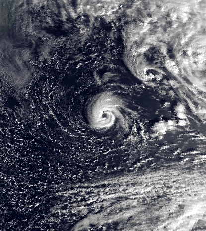
Hurricane Renee[]
| Category 5 hurricane (SSHWS) | |
 | |
| Duration | October 2 – October 19 |
|---|---|
| Peak intensity | 175 mph (280 km/h) (1-min) 894 mbar (hPa) |
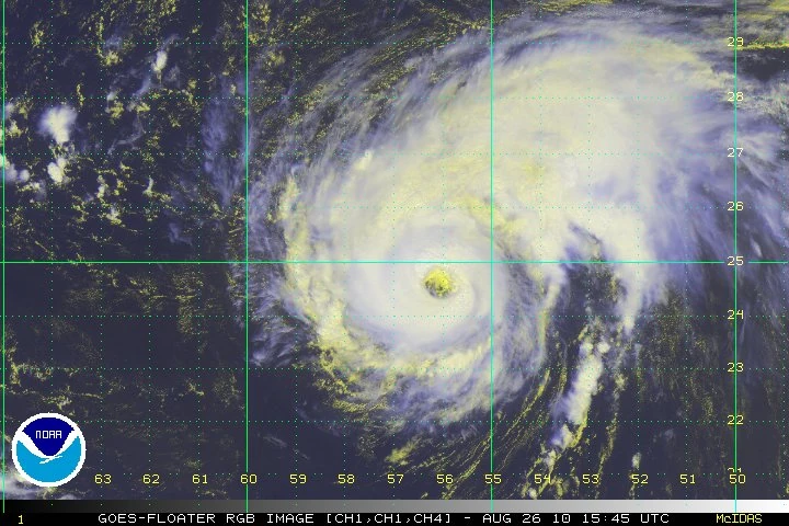
On September 30, a tropical wave exited the coast of the Canary Islands, as it began to show some convection as it began to resemble a structure similar to an extratropical cyclone by October 1, before resumably rapidly weakening and turning into an anticyclone, but on October 2 that was declared Tropical Depression Twenty One as it began to strengthen and the anticyclonic structure began to weaken as it began to turn southwest, remaining as a weak depression moving southwest, before strengthening briefly to Tropical Storm Renee. It began to fluctuate in intensity between weak tropical storm status and high end tropical depression status until October 5, where it remained as Tropical Storm Renee with 60 mile per hour winds and a minimum pressure of 990 millibars. Renee also caused Tropical Depression Twenty By now, scientists expected this to be a strong tropical storm and rapidly weaken, but that wasn't the case. On October 6, it reached 70 miles per hour and 981 millibars, before strengthening to Hurricane Renee with 80 mile per hour winds. On October 7, as it began to strengthen, it encountered an extratropical cyclone, beginning a fujiwhara and weakening to a strong tropical storm on October 8, however the system absorbed a quarter of the extratropical cyclone, causing Renee to intensify to a category 2 hurricane by October 9. On October 10, it stopped its track southwest, and began to move north north west, following a typical Cape Verde track, as it neared high end category 2 hurricane status. It then strengthened to low end category 3 status, before weakening to a high end category 2 later that day. It then began to fluctuate in intensity until it began to turn near Bermuda, rapidly strengthening to a category 5 with 165 mile per hour winds and 900 millibars on October 14. On October 15, it rapidly intensified again, strengthening to a peak of 894 millibars and wind speeds of 175 miles per hour, as it neared Bermuda, but still turned, bringing heavy rain to the island, remaining in intensity until October 17, where it began a fujiwhara with Tropical Storm Sam, as Sam began to absorb small parts of the system, weakening to a category 3 as the fujiwhara ended on October 18. On October 19, presumably going over cold waters, the hurricane rapidly weakened and dissipated. Renee caused $1.7 million in damages and one fatality, therefore Renee was not retired.
Tropical Depression Twenty Two[]
| Tropical depression (SSHWS) | |
 | |
| Duration | October 4 – October 5 |
|---|---|
| Peak intensity | 20 mph (30 km/h) (1-min) 1009 mbar (hPa) |
On October 4, a depression formed unusually south near the Gulf of Guinea, being named Tropical Depression Twenty Two as it began to get more organized and show some convection within the system, bringing heavy rain within the system, if the system made landfall, it would've caused minor damages. However, it stayed out to sea as it began to move north west west, with outer bands being extremely minor, with only light rain showers and unusually high winds being reported in the area around the Gulf of Guinea. The depression then reached a secondary intensity of 20 miles per hour and a pressure of 1010 millibars, as it moved out of the Gulf, weakening to an invest before strengthening to a depression again as it entered warm waters near Cape Verde, strengthening to its actual peak of 20 miles per hour and a pressure of 1009 millibars, before presumably missing the Cape Verde with outer bands, causing slightly more heavy rain than near Guinea, but the winds were not blowing at all, despite this unusual phenomenon. The depression then exited the Cape Verde area and began to go up north, where it began to rapidly weaken down to an invest by early on October 5, going up north before entering even more cold waters, rapidly weakening again and turning into an extremely small extratropical cyclone, before dissipating on October 6. Twenty Two caused zero damages and zero fatalities.
Tropical Depression Twenty Three[]
| Tropical depression (SSHWS) | |
 | |
| Duration | October 6 – October 8 |
|---|---|
| Peak intensity | 15 mph (30 km/h) (1-min) 1004 mbar (hPa) |
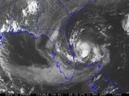
On October 5, a tropical wave exited the coast of the Lesser Antilles, going up north north east as convection began to show within the system, upgrading it to Tropical Depression Twenty Three on early October 6 as it began to move north west west, as it went near the Lesser Antilles but did not make landfall. At mid-day October 6, it went over the Bahamas as a minimal depression, causing virtually no damages, however several shingles were reported to have been blown off, which costed up to $1000 in damages after a reanalysis. The storm then reached up to its peak of 15 miles per hour as it began to get even more organized, going off the coast of Florida as it showed signs of strengthening but it never did strengthen past 15 miles per hour. On October 7, it made landfall in northern Florida near Jacksonville, causing minor damages and even an EF0 to form, causing more minor damage as it went inland. It began to go over Georgia, going northwest as it still remained despite the mountains near the northern part of Georgia. On October 8, after maintaining its intensity for two days, got teared up and split into two, which both dissipated on October 8. Twenty Three caused $1 million in damages and no fatalities.
Tropical Storm Sam[]
| Tropical storm (SSHWS) | |
 | |
| Duration | October 10 – October 14 |
|---|---|
| Peak intensity | 65 mph (100 km/h) (1-min) 994 mbar (hPa) |